

Florida map
Riviera Beach map
About 39,620 people live here (Census Bureau, 2024 estimate). The sheet's index lists 300 streets; West Blue Heron Boulevard, Dr Martin Luther King Jr Boulevard and North Military Trail cross the most grid squares. Things to do inside the boundary: Blue Water Boat Rentals.
Open the map (PDF, US Letter)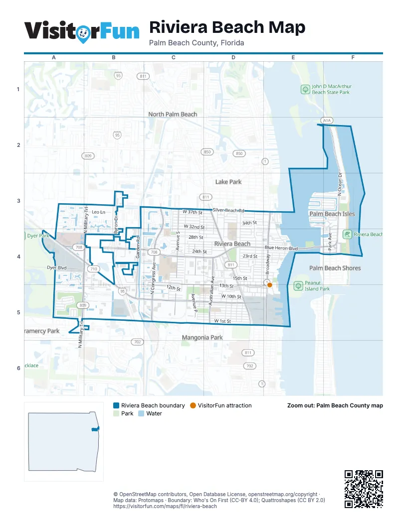
Street index of Riviera Beach
Each street on the sheet and the grid squares it crosses.
- West Blue Heron BoulevardA4, B4, C4, D4, E4
- BroadwayE3, E4, E5
- Bee Line HighwayA4, B4
- Avenue PC3, C4, C5
- Dr Martin Luther King Jr BoulevardB4, B5, C5, D5
- North Military TrailB3, A4, B4, A5
- President Barack Obama HighwayD3, D4, D5
- East Blue Heron BoulevardE4, F4
- Australian AvenueD4, D5
- North Ocean DriveF2, F3, F4
- Old Dixie HighwayD3
- Greenwood AvenueD5
- North Congress AvenueC4, C5
- West 13th StreetC4, C5, D5, E5
- Congress AvenueC3, C4, C5
- Garden RoadB4, B5
- Avenue SC3, C4, C5
- West 12th StreetC5, D5, E5
- Silver Beach RoadC3, D3, E3
- Dyer BoulevardA4, B4
- Park AvenueF3, F4
- Haverhill RoadA4
- Lake DriveF3, F4
- Beach RoadF4
- Ocean AvenueF4
- Beach CourtF4
- 10th StreetD3
- Plaza CircleF4
- Va Medical CenterA4, B4
- West 28th StreetB4, C4, D4, E4
- Avenue ED3, E3, D4, D5
- West 15th StreetC4, D4, E4
- West 10th StreetC5, D5, E5
- Wedgewood Plaza DriveC4
- West 37th StreetC3, D3, E3
- West 34th StreetC3, D3, E3
- Avenue FD3, D4, D5
- West 26th CourtC4, D4
- West 23rd StreetB4, C4, D4, E4
- West 35th StreetC3, D3
- West 36th StreetC3, D3
- West 27th StreetC4, D4, E4
- West 9th StreetC5, D5
- Avenue OC3, C4, C5
- West 25th StreetC4, D4, E4
- Woodbine WayA3, B3, A4
- Avenue H WestD3, D4
- West 30th StreetC4, D4
- West 31st StreetC4, D4
- West 32nd StreetC3, D3, D4
- Avenue H EastD3, D4
- West 33rd StreetC3, D3
- Woodbine TrailA3, B3
- Woods Edge CircleB3, B4
- West 1st StreetC5, D5
- Avenue JD3, D4, D5
- West 2nd StreetC5, D5
- West 26th StreetC4, D4
- West 24th StreetC4, D4, E4
- West 3rd StreetC5, D5
- West 29th StreetC4, D4
- Sugar Sands BoulevardE3, F3
- West 6th StreetC5, D5
- Indian Trace CircleA4
- Holiday BoulevardA5, B5
- West 17th StreetC4, D4, E4
- West 7th StreetC5, D5
- Avenue ID3, D4, D5
- Center Stone LaneC3, C4
- R J Hendley AveC3, C4
- Avenue RC4, C5
- Avenue GD4, D5
- West 4th StreetD5
- West 14th StreetC4, D4, E4
- West 20th StreetC4, D4, E4
- Canopy LaneC3
- Avenue HD4, D5
- West 11th StreetC5, D5, E5
- West 22nd StreetC4, D4, E4
- Central Industrial DriveB4
- Avenue CE4, E5
- Avenue LD4, D5
- Morse BoulevardE3, F3
- West 19th StreetC4, D4, E4
- Avenue TC3, C4, C5
- Elpine WayA3
- Seabird WayC4
- Lake Shore DriveE3, E4
- Port West BoulevardA5, B5
- Singer DriveE3, F3
- Laurel Ridge CircleC3, C4
- Marsh Harbour DriveB4, C4
- Via JardinA3, A4
- Bimini LaneE3, F3
- Avenue UC4, C5
- West 18th StreetC4, D4
- West 21st StreetC4, D4, E4
- Casa Rio CourtA3
- West 16th StreetC4, D4, E4
- Old Beacon WayA4, A5
- Westroads DriveA5, B5
- Fairview LaneE3, F3
- Coral WayE3, F3
- Canterbury Drive SouthA5
- West 5th StreetD5
- Big Torch StreetA4, A5
- Canterbury Drive NorthA5
- Byron DriveB4
- West 13th CourtD5
- Bonisle CircleA3
- Seminole Gardens CircleA3, A4
- Gulfstream WayE3, F3
- Pine Point RoadE3, F3
- Leo LaneB3
- Avenue ND3, D4, D5
- Canterbury Drive WestA5
- Aspri WayA3, B3
- Avenue MD3, D4
- Little Torch StreetA5
- Cheney WayB5, C5
- Rose Gate BoulevardC3, B4
- East 25th StreetE4
- Fiscal CourtB3
- Maniki DriveA5
- East Melaleuca LaneB5
- Avenue KD3, D5
- Oakmont DriveC3
- East 24th StreetE4
- North Sugar Sandy BoulevardF3
- Via HaciendaA3
- 49th Terrace NorthA4
- Westchester DriveA5
- Haverhill Business PkwyA4
- Doral WayA5
- East 27th StreetE4
- Avenue AE4
- East 23rd StreetE4
- East Holly LaneB5
- East 22nd CourtE4
- Interpace RoadA4
- Dorado DriveA3
- Commercial StreetD4, D5
- East 13th StreetE5
- Powell DriveE3, F3
- East Port RoadE5
- East Cypress LaneB5
- Access RoadE5
- Galleon CoveA3
- Lucaya DriveB4, B5
- Interstate Park Road NorthB4
- West 16th WayD4
- East 28th StreetE4
- Surf RoadF4
- West Middle RoadD5, E5
- Lochmore RoadA5
- North Harbor DriveF4
- Wilma CircleE4
- South Harbor DriveF4
- Interstate Park Road WestB4
- Napoli Lake DriveB3
- Carvelle DriveC3, C4
- Cabana RoadF4
- Interstate Park WayB4
- Seahawk CircleC4
- Manor DriveF3
- Industrial Drive SouthB4
- Dolphin RoadE3, F3
- Emerald LaneE3, F3
- Island RoadF4
- Avenue BE4
- Hawks Nest TerraceA4
- Big Pine WayA4
- Avenue ZC4
- Abaco LaneC4, C5
- East Industrial WayB4
- White DriveB4, B5
- Pine Ridge DriveD4, E4
- Avenue QC4
- West 32nd CourtD4, E4
- Island DriveF3, B4, C4
- Mobile StreetD3, D4, E4
- Park StreetD4, E4
- Crossing Rocks CourtA4
- Bandol StreetD3, E3
- Oakhurst WayC3
- Ocean StreetD3, E3
- Tide StreetD3, E3
- West 12th CourtC5
- Grand Bahama LaneE3
- East 22nd StreetE4
- Sonoma DriveC3
- East 29th CourtE4
- West 37th CourtC3, D3
- Freeport DriveB5, C5
- West 16th CourtB4, C4
- Shore DriveE3
- Z TerraceB4
- West Park DriveD4, D5
- Interstate Park Road SouthB4
- East 21st StreetE4
- Genove PlaceB3, B4
- Barbour RoadA4
- West 31st CourtD4
- Chateau CircleE4
- Oleander TerraceC3
- East 20th StreetE4
- West 22nd CourtD4
- Enterprise DriveB4
- Inisbrook RoadA5
- Alamanda WayC3
- Palm DriveE3
- Essex LaneC4
- Sandy LaneF3
- Sunset LaneE3
- Nassau DriveB5, C5
- Dakota PlaceA3
- Helen CourtE4
- Dennis StreetE4
- 42nd Terrace NorthB4, B5
- Yacht Harbor DriveF4
- Contego LaneA3
- Southwest 17th StreetC4
- 4th StreetD3
- Champions RunA5
- Timber Run EastA5
- Mirella DriveC3
- Lily Bank CourtA4
- Scarletta DriveC3
- Timber Run WestA5
- East 11th StreetE5
- 5th StreetD3
- Devons RoadB4
- Up The Grove LaneA5
- Sandy Bank TerraceA4
- South 25th CourtC4
- Flamingo PlaceC5
- 7th StreetD3
- Harbor Point DriveF3
- East 30th StreetE4
- Rocks Point PlaceA4, A5
- East 17th StreetE4
- Laurel Oak DriveB3, B4
- East Palm LaneB5
- Oysterwood LaneB4
- East 16th StreetE4
- North 25th CourtC4
- Delmora CourtA3
- East 34th StreetE3
- Hibiscus LaneC3
- Riviera DriveE3
- Sugar Maple DriveB4
- Cook StreetE4
- East 15th StreetE4
- Wright StreetD5
- East 12th StreetE5
- Brooks CircleC4
- Kapok LaneB3
- Pine Tree WayB4
- Timber Run NorthA5
- West 24th CourtC4
- East 14th StreetE4
- Butternut LaneB3, B4
- Edenwood RoadA3
- Bernardo LaneA4, A5
- Gardenia CourtC3
- Lewis DriveD3
- Sage Wood CourtC3
- Edenwood LaneA3
- Sonrisa DriveC4
- Willow PlaceB3
- Ardmore WayF3
- Avenue F CourtD5
- Terracotta DriveC3
- White Oak TerraceB3
- Sweet Briar LaneB3
- King Palm WayB3, B4
- Hop Tree WayB4
- Sycamore CoveB3
- Dexter WayC5
- West WayF4
- Park Manor DriveD3
- Alicante CourtB4, C4
- Douglas RoadD4, E4
- Hawksbill PlaceB4
- Maule WayC5
- Old Slip RoadE4
- Sweet Gum TraceB4
- Tortuga LaneC5
- South 24th CourtC4
- Bradbury CourtB3
- Forest LaneC4
- Jake LaneC4
- East WayF4
- North 24th CourtC4
- Tamarind DriveB4
- Booker DriveC4, C5
- Hemlock DriveB3
- Sequoia PlaceB3
- Coco Plum PlaceB3
- Tieburon StreetC3
Things to do on the Riviera Beach map
Places on the map
- 84 Lumber
- AutoZone
- Beyel Brothers Crane & Rigging
- Big Surf
- Big Thunder
- Chevron
- City of Riviera Beach Barracuda Bay Aquatic Complex
- Dan Calloway Rec Complex
- Denny's
- Doctor Mary McLeod Bethune Elementary School
- El Car Wash
- Inlet Grove High School
- InTown Suites Extended Stay West Palm Beach FL
- John F Kennedy Middle School
- KFC
- Lincoln Elementary School
- Loggerhead Marina Riviera Beach
- Long Pine Country Club
- Marriott Oceana Palms 1
- Marriott Oceana Palms 2
- Mullins Lumber
- Nick's Creative Marine
- Ocean Lane Apartments Motel
- Ocean Reef Park
- Olympie Auto Body
- Palm Beach Aluminium
- Palm Beach Marriott Singer Island Beach Resort & Spa
- Phil Foster Park
- Publix
- Rapids Lazy River
- Rapids Water Park
- Rivera Beach Bicentennial Park
- Rivera Beach Fire Rescue Station 88
- Riviera Beach Marina
- Riviera Beach Post Office
- Riviera Beach Public Library
- Splish Splash Lagoon
- Suncoast Community High School
- Vacation Inn Resort
- Wells Recreational Center
Next to Riviera Beach
- Gramercy Park
- Lake Park
- Mangonia Park
- North Palm Beach map
- Palm Beach Shores
© OpenStreetMap contributors, Open Database License, openstreetmap.org/copyright · Map data: Protomaps · Boundary: Who's On First (CC-BY 4.0); Quattroshapes (CC BY 2.0)















