

Florida map
Wellington map
About 63,258 people live here (Census Bureau, 2024 estimate). The sheet's index lists 300 streets; Wellington Trace, Forest Hill Boulevard and South Shore Boulevard cross the most grid squares. Things to do inside the boundary: The Mall at Wellington Green.
Open the map (PDF, US Letter)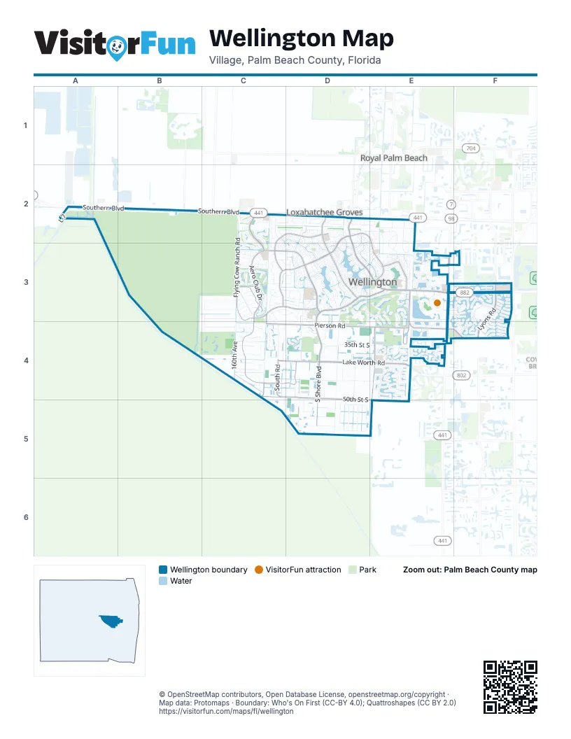
Street index of Wellington
Each street on the sheet and the grid squares it crosses.
- Southern BoulevardA2, B2, C2
- State Road 7E3, E4
- Forest Hill BoulevardD2, D3, E3, F3
- South Shore BoulevardD3, E3, D4, D5
- Wellington TraceD2, E2, C3, D3, E3
- Greenview Shores BoulevardC3, D3
- Palm Beach Point BoulevardC3, C4, D4
- 50th Street SouthC4, D4, D5, E5
- Greenbriar BoulevardC3, D3
- Pierson RoadC4, D4, E4
- Stribling WayE3, E4, F4
- Lake Worth RoadD4, E4
- Lyons RoadF3, F4
- Big Blue TraceD2, D3
- 40th Street SouthC4, D4, E4
- Paddock DriveC2, D2, C3
- Binks Forest DriveC2, C3
- Aero Club DriveC3
- 120th Avenue SouthE4, E5
- Birkdale DriveE3
- Fairlane Farms RoadE4
- South RoadC4
- 150th Avenue SouthC3, C4
- Lion Country Safari RoadB2
- Fatio BoulevardF3, F4
- Villagewalk CircleF3, F4
- Flying Cow Ranch RoadC2, C3, C4
- Appaloosa TrailC3, D3, D4
- Indian Mound RoadC4, D4, E4
- Polo Club RoadD3, E3
- Horseshoe TraceC2, D2, C3, D3
- Wellington Preserve BoulevardD5
- Versailles BoulevardE4
- South Club DriveC3
- 130th Avenue SouthD4, D5
- Drafthorse LaneC3, D3
- Meadow Wood DriveC3
- Isles Vista BoulevardE4
- Old Hammock WayE3
- Exotica LaneD2, D3
- 160th AvenueC4
- Stirrup LaneC2, D2
- Ring RoadE3
- Alexandra CircleF3
- Primrose LaneD3
- Old Country RoadD2, E2, D3, E3
- Equestrian WayC3, D3
- Equine LaneD4, E4
- Meadowbreeze DriveD3
- The 12th FairwayE3
- Wellington's Edge BoulevardE3
- Southfields RoadD4
- Grand Prix Farms RoadC4
- Siena CircleE3, E4
- Country Golf DriveC3
- La Mirada CircleD2
- Bent Creek RoadC2
- Gene Mische WayC4
- Old Hampton DriveC4
- Sunnydale DriveD3, E3
- Hurlingham DriveD3, D4
- Greentree TrailD2
- Wellington Green DriveE3
- South 125th AvenueD4, D5
- Greenview Cove DriveD3
- 35th Street SouthD4, E4
- Rainbow RoadD4, D5
- Acme RoadE2
- Hollow Tree LaneB3, C3
- Sunnyland LaneC4
- Cindy DriveE2, E3
- Trianon PlaceE4
- Gulf Pine CircleC2
- Shepard PlaceE3, F3
- Doubletree CircleD2
- Dupont PlaceF3
- Lake Breeze DriveD3
- Northumberland CircleD3
- 57th Place SouthD5
- Rustic RoadC3
- Norris RoadC4
- Deer Path LaneC3
- Squire DriveC2, C3
- Cypress Green CircleC2, C3
- Estancia LaneC4
- Belmont TraceC3, D3
- Pelham CircleD4
- Equestrian Club DriveD4
- Ishnala CircleD2
- 46th Lane SouthC4
- Shaughnessy DriveE3, F3, E4, F4
- Via Grande WestE3, F3
- Wiltshire Village DriveD3
- Rolling Rock TrailC3, D3
- Long Meadow DriveE3, E4
- Quercus LaneD2, E2
- Blue Cypress LaneD3, E3, D4
- Miramontes CircleE4
- Beacon CircleE3
- Aster AvenueD3
- West Rambling DriveE2, E3
- Rambling Drive CircleE2, E3
- Yarmouth DriveD3
- Wyndcliff DriveE3
- Laredo WayD5
- Rolling Meadows CircleC3
- Lasso WayD5
- Old Lighthouse CircleE4
- Shearson BoulevardF3
- East Rambling DriveE2, E3
- White Coral DriveD3
- Corsica DriveC3
- L-7A2
- Moon Bay CircleE4
- Via EleganteE3, F3
- Folkstone CircleD3
- Columbine AvenueD2, D3
- Pine Valley DriveE3
- Polo Lake East DriveE3
- Wellington Shores DriveE4
- Clydesdale AvenueC3
- Staimford DriveD3
- Cypress Park DriveC2, C3
- Santa Barbara DriveD4
- Olive DriveE3
- Lake Wellington DriveD2, D3
- Saint Andrews PlaceE3
- Hutton BoulevardE3, F3
- Vinings CircleD3
- Forest Club Drive WestD2, D3
- Wightman DriveE3
- Bahia Isle CircleE4
- 55th Street SouthD5
- Hollyhock RoadD3
- Barberry DriveD3
- Headwater CircleD3
- Island Reef DriveE4
- Osprey Pointe CircleE4
- Doubletree TrailD2
- Waterway Cove DriveE3
- Summerwood CircleE3
- Phipps LaneF4
- Oak Berry CircleE3
- Emerald Forest DriveD3
- Stonegate DriveD3
- Amesbury CircleD3
- Winding Oak LaneE3, E4
- 140th Avenue SouthD3, D4
- Lake Isles DriveE4
- Callington DriveD3
- Lynton CircleD3
- Geranium PlaceD3
- Quarter Horse TrailD4
- Cedar Bluff PlaceC3
- Payson WayF3, F4
- Windward Cove LaneE4
- Halter RoadC3, D3
- Natures Point LaneC4
- Polo Gardens DriveD3
- Cindy Circle LaneE2, E3
- 52nd Place SouthD5
- Azure AvenueD2, D3
- Imperial Point LaneC4
- Canyon WayE3
- Wranglewood DriveD2, E2, E3
- Hamblin WayF4
- Take Off PlaceC3
- Grantham DriveD3
- Maidstone DriveE3
- Sheltingham DriveE3, E4
- Service Road 6E3
- Laurel TrailC3, D3
- Via ChristinaD4
- Westhampton CircleD3
- Galleria StreetE3
- Pelican DriveE3
- Areaca DriveD2, E2
- Wellington Parc DriveE4
- Sunderland AvenueD3
- Via Grande EastF3
- Sawyer TerraceE3, F3
- Donahue WayF4
- Florence StreetE3, E4
- Solaro BoulevardE3
- Skipiks WayC3, C4
- Players CourtD3, E3
- Wimbledon CircleE3
- Sage AvenueC3
- Barnstaple CircleD3
- Stables WayD4
- Raintree LaneD3
- Ocean Breeze LaneC4
- Pacer CircleC2, D2
- Pinto CircleD2, D3
- Garden Point TrailC4
- Sailboat CircleD3
- Stratford StreetD3, E3
- Treanor TerraceF3
- Shower Tree WayE3
- Longlea TerraceC3
- Cedar Grove LaneC3
- Oakmont Estates BoulevardE4
- Jonquil PlaceD3
- Oak Bend WayE3
- Isles BoulevardE4
- Olympia BoulevardF3
- Las Casitas DriveE3
- Larch WayE3
- Delemar CourtF3, F4
- Medical Park BoulevardE3
- Cypress Island WayD3
- Vanderbilt DriveE4
- Block Island RoadD3
- Woodworth CourtE3, F3
- Scribner LaneE3, F3
- Montauk DriveD3, E3
- Collonade DriveE4
- Greentree DriveD3
- Red Pine TrailE3
- Sawgrass CourtD2
- Pinetta CircleE3
- Paradise Cove LaneE4
- Farmington CircleD3
- Wellington RoadE2
- Chapparel WayE3
- Essex DriveD3
- Hickory TrailD3, E3
- White Pine DriveE3
- Shoreline DriveD3
- Oak Chase CourtC2
- Via BrillianteF3
- Golf Brook DriveE3
- Guilford CircleD3
- Whippoorwill WayF3
- Edgewater CircleE4
- Pineacre LaneD2
- Palma LaneC4
- 138th Trail SouthD4, D5
- Guilford WayD3
- Muir CircleE3
- Sugar Pine TrailD3, E3
- Forest Glen LaneC2, C3
- Meadow AvenueD3
- Trotter CourtD3
- South Rambling DriveE3
- Las Palmas RoadC4, C5
- Buckland StreetD3
- Blackberry DriveD2
- Suellen CircleE3
- Cooper WayF3
- Royal Fern BoulevardE3
- Stotesbury WayF3
- Mariners Cove DriveE4
- Wellington Lakes BoulevardD3
- Anhinga DriveE3
- Carriage Brooke DriveE3
- Bluff Harbor WayE4
- Rolling Rock PlaceC3
- Wingate BendD3, E3
- Whispering Willow DriveC2
- Fortune CircleE4
- Golden Point LaneC4
- Oleaster AvenueD2
- Balsan WayF3
- Hartridge TerraceF4
- Worswick CourtF3
- Danforth TerraceF3, F4
- Goldenrod RoadD3
- Water Bend CourtE4
- Ivanhoe LaneE4
- Bay View WayE3
- Hawthorne PlaceD3
- Seaford DriveD3
- Turf LaneD3
- Old Englishtown RoadD2, D3
- Pisa RoadE3, E4
- Wyeth CourtF3
- Staimford CircleD3
- Knightsbridge PlaceE4
- Verdmont LaneF4
- Ambassador DriveD4
- Quiet Woods RoadD3
- Turnstone DriveE3
- Mizner WayD3
- Xanthus LaneF4
- Twin Oaks WayE3, E4
- Chatsworth Village DriveD3
- Foresteria AvenueD2, D3
- Windsor Bay PlaceE4
- World Cup LaneD4
- Isles Way SouthE4
- 53rd Road SouthD5
- Mulberry PlaceD3
- Isles View DriveE4
- Bedford Mews DriveD3
- Quito PlaceF4
- Lime DriveE3
- Kingsway RoadD3
- 128th Terrace SouthD4
- Manatee Bay LaneE4
Things to do on the Wellington map
Places on the map
- 1st Championship Field
- 5/8 mile
- Bahia Bay
- Big Blue Preserve
- Binks Forest Golf Club
- Bluff Harbor
- Cell 1
- Cell 2
- Cell 3
- Cell 4N
- Cell 4S
- Cell 5
- Cell 6
- Cell 7
- Courtyard Shops at Wellington
- East Distribution Cell
- Equestrian Center
- Equestrian Trail
- Field 11
- K Farm
- Marina Bay Estates
- Mariners Cove
- Mocanda Property
- Palm Beach Equestrian Center
- Palm Beach Polo Golf & Country Club
- Regatta Bay Estates
- Shoppes at Chancellor
- Stonegate
- Stormwater Treatment Area 1 East
- The Estates
- The Mall at Wellington Green
- The Wanderers Club
- Wellington Marketplace
- Wellington Village Park
- West Distribution Cell
- Windsor Bay Estates
- Windward Cove
Next to Wellington
- Loxahatchee Groves
- Royal Palm Beach map
© OpenStreetMap contributors, Open Database License, openstreetmap.org/copyright · Map data: Protomaps · Boundary: Who's On First (CC-BY 4.0); Quattroshapes (CC BY 2.0)















