

Georgia map
Acworth map
About 22,624 people live here (Census Bureau, 2024 estimate). The sheet's index lists 300 streets; Lake Acworth Drive, Cobb Parkway and South Main Street cross the most grid squares. Also on it: Cobblestone Golf Course, Lake Acworth and Logan Farm Park.
Open the map (PDF, US Letter)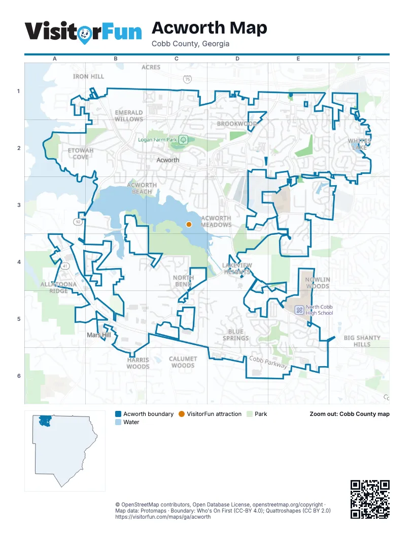
Street index of Acworth
Each street on the sheet and the grid squares it crosses.
- Cobb ParkwayA4, A5, B5, C5, D6, E6
- Lake Acworth DriveB1, C1, D1, E1, B2, A3, B3, A4
- Allatoona GtwyC1, C2
- Cherokee StreetC1, C2
- Allatoona GatewayC1
- Cherokee RoadE1
- Mars Hill RoadB5
- South Main StreetC2, D2, D3, D4
- Cowan RoadD1, E1, D2
- Old 41 HighwayD4, E4, E5, F5
- North Main StreetB1, B2, C2
- Baker RoadE1, F1, F2
- Cowan ConnectorD2
- Acworth Due West RoadC4, C5
- New McEver Road NorthwestD3, E3
- Mars Hill Road NorthwestB3, B4, B5
- Southside DriveC2, D2
- Baker Grove RoadE1, E2
- Nance RoadC4, D4, C5
- Blue Springs Road NorthwestE5, E6
- Hickory Grove Road NorthwestE2, E3, F3
- Kemp Ridge RoadA4, B4
- Acworth Industrial Drive NorthwestD2, D3
- Acworth Summit BoulevardC5
- Old Cowan RoadD2
- Priest RoadE1
- Mars Hill Church Road NorthwestB6
- Acworth Due West Road NorthwestC5
- Northside Drive NorthwestB1, B2, C2
- Lake Park LaneF1, F2, F3
- Lakewood DriveA2, B2
- Allatoona DriveA2
- Windcroft Circle NorthwestE2
- Ragsdale RoadA3, B3
- West Lakeshore DriveA2, B2
- McEver Park CircleE4
- Liberty Commons Drive NorthwestE5, E6
- Clubhouse Drive NorthwestD5, D6
- Walforde BoulevardE3, F3
- Baker Plantation DriveE1, E2, F2
- Liberty Square DriveB1, C1
- Cool Springs DriveD5
- Wayland CircleE1, D2, E2
- Quick Water Landing NorthwestD5, E5
- Old McEver RoadD3
- Lake Park TerraceF2
- McEver Park DriveE3, E4
- Worth StreetD3
- McLain CircleB2
- Terrace DriveC2, D2
- Ballenger RoadA4
- Spring Meadow Drive NorthwestD2
- School StreetC2
- Lemon StreetC2, C3
- Logan RoadC1, C2
- Dallas StreetB2, C2, B3
- Palm CircleD5, E5
- Brandy Ann Drive NorthwestC2
- Lake Park BendF2
- Stanton Place LaneE2
- Rivers Run TraceE1, E2
- Academy StreetB2, C2, B3
- Laurel Drive NorthwestC4, C5
- Creel Chase NorthwestC5, D5
- Butler Springs TraceD5, E6
- Golflinks DriveC4
- Creekside Village DriveD5, D6
- Mc Clure RoadC5, B6
- Cemetery RoadA2, B2
- Grove DriveE2
- Pine Hill CircleD2
- Toccoa DriveD2, D3
- Clover RoadE5
- Clear Lake WayB4
- Westside DriveC3, D3
- Julian WayE2, F2
- Albright Commons NorthwestE5
- Cyrus Crest CircleD6
- Maple DriveC2, C3
- Huddlestone Bridge ParkwayE3
- Summit Circle NorthwestD3
- East Spring Meadow Drive NorthwestD1, D2
- Grove Park TerraceE2
- Carnes StreetB2, C2
- Collins AvenueB2
- Lakeview Drive NorthwestD4
- Lee StreetD2
- Town Square Circle NorthwestD5
- Abernathy Farm WayA4
- Logan WayC1, D1
- Collins CircleB2, B3
- Mitchell Hill DriveC2
- Garden CircleC2, D2
- Rockdale DriveC3, D3
- Lake Park TrailF2
- Park Forest Drive NorthwestD5, D6
- Mc Phail DriveD4, D5
- Dustin Drive NorthwestD3
- Seminole DriveC2, C3
- Park StreetC2, C3
- Pepper CircleC1
- Elderberry DriveE3
- Winn StreetC2, C3
- Taso TrailF1
- Zephyrhills DriveE2
- Robinson StreetC2, C3
- South Lakeshore DriveC3
- Athena CourtF1
- Yukon TrailE2
- Industrial Center LaneE3
- Taylor StreetC2
- Delacorte DriveE3, F3
- Pinehurst CircleD1, E2
- Lake Park Ridge WestF2
- Martingale LaneB4, C4
- Haynes Mill CourtC5
- McPearson DriveE3, E4
- Pelham Drive NorthwestD2
- Grogan StreetD3
- Dewberry CircleA2
- Hillview DriveC2
- Freedom Landing NorthwestE6
- Blue Springs Walk NorthwestE6
- Maryland DriveD1
- Baker Plantation WayE1, E2
- Movis Point NorthwestE3
- Parke Brooke DriveE1, E2
- Cowan CircleD2
- Blue Springs Station NorthwestE5
- Lambeth DriveD1, D2
- Grove TrailE2
- Ross RoadC1
- Windcroft LaneE2
- Austin Farm TrailC5
- Glenwood DriveD2
- Kathryn Glen DriveE1
- Columbus CircleE3, F3
- Old Cherokee Street NorthwestC1, C2
- Gibson StreetC2, C3, D3
- Estuary DriveF2
- Ivey RoadA5, B5
- Washington Commons NorthwestE5
- Acworth Forrest DriveD6
- Willis StreetC2
- Wood StreetB2
- Bass Way NorthwestC5, D5
- Toonigh RoadE3, F3
- Justice Mill Court NorthwestE5
- Singletree WayB4, C4
- Spring StreetD2
- Amber Lake LaneC2
- East Lakeshore DriveC2, C3
- Beach StreetB3, C3
- Spring Leaf LaneD2
- Lakeview Way NorthwestD4
- Darter DriveC5
- Park Forest Way NorthwestD5, D6
- Ulreich Street NorthwestD4
- Clarkdale DriveD2, D3
- McDowell DriveE3, E4
- Noah Overlook WestF2
- Rayburn StreetC3, D3
- Aspen Springs NorthwestE4
- Cantrell Road NorthwestE3
- Edinburgh TerraceD1
- Archer PlaceB1, B2
- Fowler Street NorthwestB1
- Adams CircleB2, B3
- Juniper DriveD5
- Tanyard DriveC1
- Batiste LaneF1, F2
- Caddie DriveC4
- Lighthouse LaneF2
- Lombardy WayB2
- Four Iron Place NorthwestD5
- Little Harbor WayC1
- Mulligan Lane NorthwestC4
- Lake Park DriveF2
- Noah DriveF2
- Hillside DriveB2
- Lucille AvenueA1, B1
- Fred J Kienel DriveC1, C2
- Spearmint LaneE3
- Brandy Ann Court NorthwestC1, C2
- Highland DriveD2, E2
- Orr RoadB4
- Proctor Landing NorthwestA4
- Lighthouse PointeF1, F2
- Cove StreetA2, B2
- Chapel RoadD5, E5, E6
- Hunters Cove DriveA1
- Park BridgeD2
- Bridlecreek DriveB4, C4
- Northridge DriveE1
- Vail DriveD1
- Robin Court NorthwestD1, D2
- Darter Drive NorthwestC4, C5
- Acworth Landing Drive NorthwestD1
- Hillcrest RoadC3
- Tennis Court LaneD5
- Lauren WayC4, C5
- Spring Ridge DriveD5
- Grove Park WayE2
- Cottage Oaks DriveD1
- Liberty NorthwestC1
- Acworth Oaks Drive NorthwestE1
- Amysaye WalkB6
- Two Iron Trail NorthwestD5
- North Cyrus Crest DriveD6
- Clear Creek CrossingE5
- Dogwood LaneB5
- Pastry LaneE2
- North Field WayE5
- Cardinal WayC1
- Saddle Gate LaneB2
- Peartree DriveE2
- Estuary RidgeF2
- Lakeview StreetC3
- Souffle CourtE2
- Bowsprit PointB2
- Magnolia Cottage WayC1
- Griggs StreetB2
- Keystone RidgeD1
- Robinson Square DriveB1
- Fowler RoadD5, E5
- Crescent Hill LaneE2, F2
- Fowler Circle NorthwestB1
- Noah RidgeF2
- North Bend WayC4
- Darcy Court NorthwestD4
- Dixie AvenueB2, C2
- White Lake Drive NorthwestF2
- Lake Park Ridge EastF2
- Moon StreetC2
- Darter Run NorthwestC5, D5
- Albany DriveD2
- Acworth Enclave DriveB1
- Marina LaneF1
- Hudson DriveA2
- Fort Sumter LandingE3
- Spring Ridge CourtD5
- Ansbury PlaceB5
- Bass Pointe NorthwestD5
- Marina Trace DriveF1
- Balto WayE3, F3
- SaddleOaks DriveB2
- Carson Glen LaneE1
- High Battery BluffD3, E3
- Henry CourtD2
- Jenny DriveC2
- Wexford Downs WayC2
- Peach TerraceE2
- Cherry StreetC1
- Creel Court NorthwestC5
- Oakwood TerraceC4
- Hamstead LaneA1
- Woodvalley DriveA2
- Blue Springs Trace NorthwestE6
- Bass Chase NorthwestC5, D5
- Holborn WayA1
- Willow Street NorthwestB2
- EasterbrookeC4, C5
- Hill StreetA2
- Two Iron WayD5
- Silver PointeC1
- Franklin StreetD2
- Joseph DriveA5
- Deepwater CoveC1
- Town Square Drive NorthwestD5
- Snowshoe CourtD1
- Lake Acworth Village DriveC1
- Robinson RoadB1
- Creek CourtB2
- Overlook DriveC2
- Bish RoadB1
- Dawn DriveB2
- Spring Street ExtendedD2
- Thomasville DriveD2
- Vernon Commons NorthwestE5, E6
- Dogwood DriveA2
- Estuary CircleF2
- Ireland DriveD1
- Cinema DriveC5
- Loring RoadD6
- Lake City Industrial Court NorthwestD3, E3
- Terret Trace NorthwestC4
- Westridge DriveE1, E2
- Parfait PlaceE2, F2
- Cyrus Ridge WayD6
- McEver Village LaneD3
- Orange DriveE2
- Baker Ridge PlaceE1, E2
- Allantoona Springs LaneB4
- Tide Water CourtD3
- Windcroft CourtE2
- Lily Way NorthwestE5
- Kentland DriveE3
- Liberty Hill Way NorthwestE5, E6
- Tasos WayF1
- McGregor WayE4
Places on the map
- 1885 Grill
- 3 Minute Express Wash
- Acworth City Hall
- Acworth Intermediate School
- Acworth Park & Ride
- Acworth Police Department
- Acworth Post Office
- Acworth Presbyterian Church
- Acworth United Methodist Church
- Advance Auto Parts
- Albert Matthews Field
- ALDI
- Allatoona Drive
- AutoZone
- Awtrey Middle School
- Barber Middle School
- Beverage Mart
- Big Dan's Car Wash
- Bubolo Medical
- Burger King
- Cauble Park
- Chase
- Chevron
- Chili's
- Christian Brothers Automotive
- Coats and Clark Field
- Cobblestone Golf Course
- Dallas Landing Park
- Extra Space Storage
- Lake Acworth
- Liberty Hill Cemetery
- Logan Farm Park
- McCall Primary School
- North Cobb High School
- The UPS Store
- Walmart Supercenter
- Whites Lake
Next to Acworth
- Allatoona Ridge
- Allatoona Shores
- Big Shanty Hills
- Calumet Woods
- Countryside Estates
- Davenport Trace
- Edgewood Estates
- Harris Woods
- Homestead Acres
- Iron Hill
- Kennesaw Acres
- Lake Manor
- Lakeview Heights
- Mars Hill
- Mars Hill Acres
- Mars Hill Downs
- Nowlin Woods
- Owens Meadows
- Whites Lake
- Whitney Station
© OpenStreetMap contributors, Open Database License, openstreetmap.org/copyright · Map data: Protomaps · Boundary: Who's On First (CC-BY 4.0); Quattroshapes (CC BY 2.0)















