

Georgia map
Cobb County map
About 787,538 people live here (Census Bureau, 2024 estimate). The sheet's index lists 158 streets; Northwest Corridor Express Lanes, Larry McDonald Memorial Highway and Cobb Parkway cross the most grid squares. Things to do inside the boundary: Kennesaw Mountain National Battlefield Park, Marietta and Six Flags Over Georgia.
Open the map (PDF, US Letter)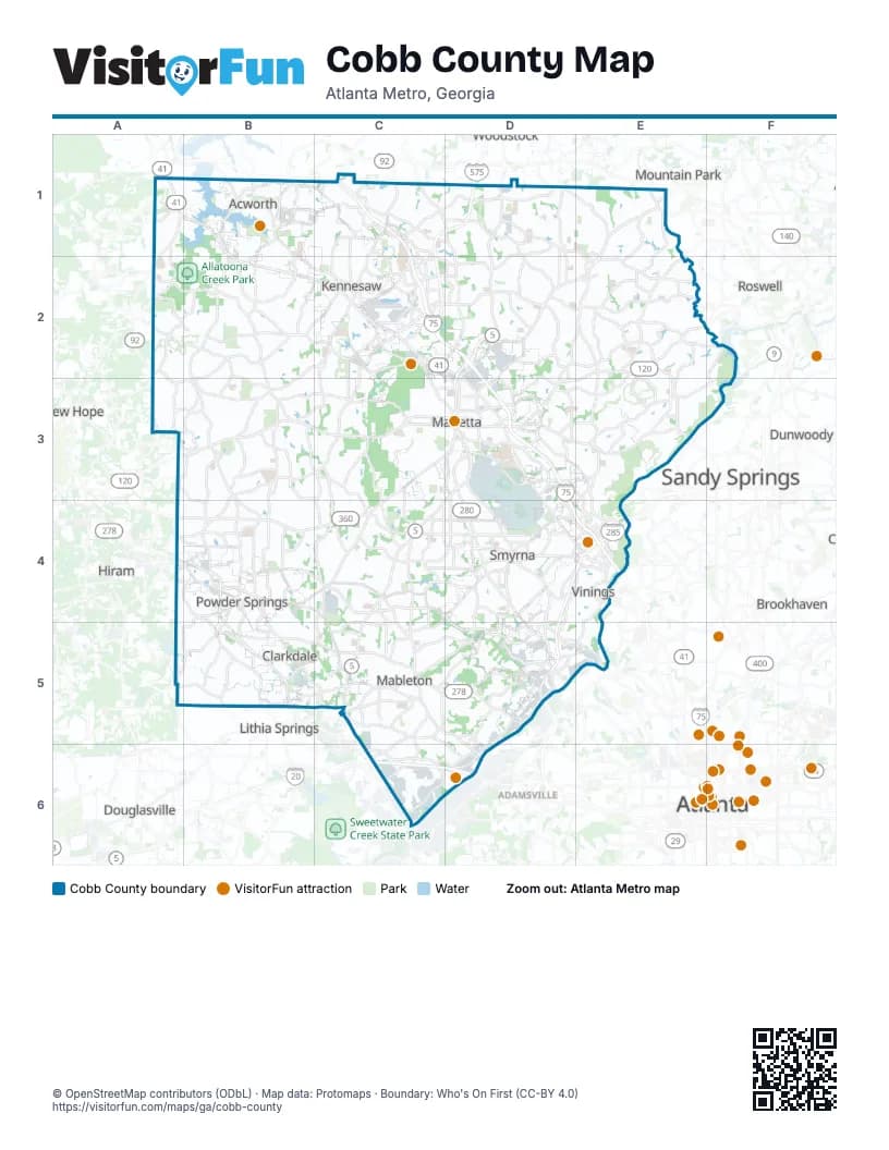
Street index of Cobb County
Each street on the sheet and the grid squares it crosses.
- Awtrey Church RoadA1
- Cedarcrest RoadA1
- Cobb ParkwayA1, B1, B2, C2
- Dallas Acworth Highway NorthwestA1, A2
- Allatoona GatewayB1
- Allatoona GtwyB1
- Baker RoadB1, C1
- Cherokee RoadB1
- Cherokee StreetB1
- Cowan RoadB1
- Lake Acworth DriveB1
- Mars Hill RoadB1, B2, B3
- North Main StreetB1, C2
- Old 41 HighwayB1, B2, C2
- South Main StreetB1, C2
- Bells Ferry Road NorthwestC1, D1, C2, D2
- Cherokee Street NorthwestC1, C2
- Frey Road NorthwestC1, C2
- George Busbee Parkway NorthwestC1, C2
- Larry McDonald Memorial HighwayC1, C2, D2, D3, D4, E4
- Northwest Corridor Express LanesC1, D1, C2, D2, D3, D4, E4
- Phillip Landrum Memorial HighwayC1, D1, C2, D2
- Wade Green RoadC1
- Blackwell Road NortheastD1, D2
- Canton RoadD1, D2
- Canton Road NortheastD1, D2
- Main StreetD1
- Shallowford Road NortheastD1, E1, E2
- Highway 92E1
- Sandy Plains Road NortheastE1, D2, E2
- Woodstock RoadE1
- Dallas Acworth HighwayA2
- Stilesboro RoadB2, C2
- Barrett Lakes Boulevard NorthwestC2
- Barrett ParkwayC2, D2, C3, C4
- Chastain RoadC2
- Chastain Road NorthwestC2, D2
- Church Street Extension NorthwestC2, D2, D3
- Cobb Parkway NorthC2, D2, D3
- Cobb Parkway NorthwestC2
- Ernest West Barrett ParkwayC2, C3
- McCollum Parkway NorthwestC2
- South Main Street NorthwestC2
- Watts DriveC2
- Allgood Road NortheastD2, D3
- Bells Ferry RoadD2
- Bells Ferry Road NortheastD2
- Blackwell RoadD2
- Canton Road ConnectorD2, D3
- East Piedmont Road NortheastD2, D3
- New Chastain RoadD2
- Piedmont RoadD2
- Piedmont Road NortheastD2
- Post Oak Tritt Road NortheastD2, E2
- Scufflegrit Road NortheastD2
- Johnson Ferry Road NortheastE2, E3
- Old Canton Road NortheastE2, E3
- Roswell RoadE2, D3, E3
- Sandy Plains RoadE2
- Hiram Acworth HighwayA3
- Burnt Hickory Road NorthwestB3, C3
- Corner RoadB3, B4
- Dallas HighwayB3, C3
- Due West Road NorthwestB3
- Due West Road SouthwestB3
- Lost Mountain RoadB3, B4
- Old Lost Mountain RoadB3, B4
- Villa Rica Road SouthwestB3, C3, B4
- Powder Springs Road SouthwestC3, B4, C4
- Powder Springs Street SouthwestC3, D3
- Villa Rica Road Southwest;West Sandtown Road SouthwestC3
- Whitlock Avenue NorthwestC3
- Whitlock Avenue SouthwestC3, D3
- Atlanta Road SoutheastD3, D4, D5
- Atlanta Street SoutheastD3
- Austell Road SoutheastD3
- Austell Road SouthwestD3, C4, D4
- Cherokee Street NortheastD3
- Church Street NorthwestD3
- Cobb Parkway SouthD3, D4, E4
- Cobb Parkway SoutheastD3, D4
- Delk Road SoutheastD3, E3
- Fairground Street SoutheastD3
- Gresham Road NortheastD3
- North Fairground Street NortheastD3
- North Marietta ParkwayD3
- Powers Ferry Road SoutheastD3, E3, E4
- Roswell Street SoutheastD3
- Sewell Mill Road NortheastD3
- South Cobb DriveD3, D4, D5
- South Fairground Street SoutheastD3
- South Marietta ParkwayD3
- South Marietta Parkway SoutheastD3
- South Marietta Parkway SouthwestD3
- South Park Square NortheastD3
- South Park Square SoutheastD3
- Wallace Road NortheastD3
- Johnson Ferry Road SoutheastE3
- Lower Roswell Road SoutheastE3
- Terrell Mill Road SoutheastE3, D4, E4
- Macland RoadA4
- Macland Road SouthwestA4, B4, C4
- Moon RoadA4, B4
- Austell Powder Springs RoadB4, B5, C5
- Brownsville RoadB4, A5, B5
- C H James ParkwayB4, B5
- Florence RoadB4
- Hopkins RoadB4
- Macedonia RoadB4, C4
- Marietta StreetB4
- Marietta Street SouthwestB4
- New Macland RoadB4
- Powder Springs Dallas RoadB4
- Powder Springs RoadB4
- Richard D Sailors ParkwayB4
- Austell RoadC4, C5
- East-West ConnectorC4, D4, D5
- Floyd Road SouthwestC4, C5
- Windy Hill Road SouthwestC4, D4
- Atlanta Bypass / The PerimeterD4, E4, D5
- Concord RoadD4
- Concord Road SoutheastD4
- Cumberland Boulevard SoutheastD4, E4
- Cumberland Parkway SoutheastD4, E4, D5
- Paces Ferry Road SoutheastD4, E4
- South Atlanta RoadD4, D5
- Spring Road SoutheastD4, E4
- Windy Hill Road SoutheastD4, E4
- Akers Mill Road SoutheastE4
- Circle 75 Parkway SoutheastE4
- Horace E Tate FreewayE4
- Interstate North Parkway West SoutheastE4
- Powers Ferry RoadE4
- Powers Ferry Road NorthwestE4
- Windy Ridge Parkway SoutheastE4
- Doctor Luke Glenn Garrett Junior Memorial HighwayB5
- Hiram Lithia Springs RoadB5
- North Sweetwater RoadB5
- Thornton RoadB5
- Fontaine RoadC5, D5
- Fontaine Road SouthwestC5
- Mableton ParkwayC5, D5, D6
- Maxham RoadC5
- Veterans Memorial Highway SouthwestC5, D5
- Veterans Memorial Parkway SouthwestC5
- Discovery BoulevardD5, D6
- Fontaine Road SoutheastD5
- Highlands Parkway SoutheastD5
- Oakdale Road SoutheastD5
- South Atlanta Road SoutheastD5, E5
- Veterans Memorial Highway SoutheastD5
- Marietta Boulevard NorthwestE5
- Cityview DriveC6, D6
- Lower River Road SouthwestC6
- Riverside ParkwayC6
- Tom Murphy FreewayC6, D6
- Lee Industrial BoulevardD6
- Six Flags ParkwayD6
Things to do on the Cobb County map
Places on the map
- A L Burruss Nature Park
- Accent Marietta
- Acworth
- Air Force Plant 6
- Airport Industrial Park
- Akers Mill Square
- Al Bishop Softball Complex
- Allatoona Creek Park
- Allatoona High School
- Arbor Bridge
- ARIUM Cumberland
- Arthurs Vinyard
- Atlanta Country Club
- Atlanta Country Club Golf Course
- Austell
- Avana Cityview
- Avana Cumberland
- Avendir At Winset
- Avenue East Cobb
- Avonlea Riverside
- Avonlea Square Apartments
- Avonshire
- Baldwin Paving - Plant #7
- Barrett Heights
- Barrett Pavilion
- Barrett Walk Apartments
- Baywater
- Beacon Hill
- Becketts Walk
- Bell Kennesaw Mountain
- Bellingham Apartment Homes
- Belmont Place Apartments
- Bentley Ridge Condominiums
- Big Shanty Park
- Bishop Lake
- Blackwell Park
- Blakeford
- Brandon Ridge
- Branson Walk
Next to Cobb County
- Adamsville
- Atlanta map
- Brookhaven
- Douglasville
- Dunwoody
- Hiram
- Lithia Springs
- Mountain Park
- New Hope
- Roswell
- Sandy Springs
- Woodstock
© OpenStreetMap contributors (ODbL) · Map data: Protomaps · Boundary: Who's On First (CC-BY 4.0)