

Georgia map
Catoosa County map
About 68,940 people live here (Census Bureau, 2024 estimate). The sheet's index lists 300 streets; Old Alabama Road, Nashville Street and Chattanooga Road cross the most grid squares. Things to do inside the boundary: Chickamauga and Chattanooga National Military Park.
Open the map (PDF, US Letter)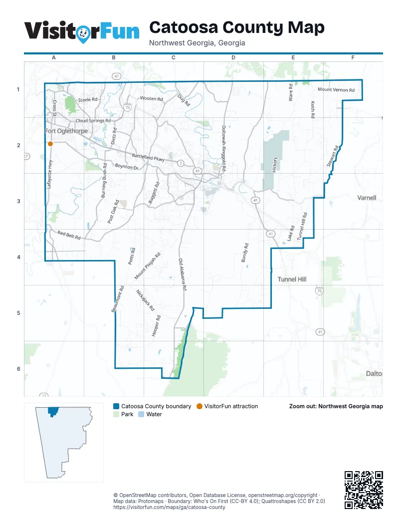
Street index of Catoosa County
Each street on the sheet and the grid squares it crosses.
- Battlefield ParkwayA2, B2, C2
- Nashville StreetC1, C2, C3, D3
- Lafayette HighwayA2, A3, A4
- Chattanooga RoadF1, D3, E3, E4
- Lafayette RoadA1, A2, A3
- Ringgold RoadB1
- Rock Springs CreekA1
- Old Alabama RoadF1, C3, C4, C5, C6
- Cloud Springs RoadA1, B1, A2, B2
- Three Notch RoadC2, B3, C3, B4
- Boynton DriveB2, C2, C3
- Ooltewah-Ringgold RoadD1, D2, D3
- Lakeview DriveA1, B1, B2
- Alabama HighwayC3
- Catoosa ParkwayD3, E3
- Lafayette StreetC3, D3
- Tennessee StreetD2, D3
- Page RoadA1
- High StreetD2, D3
- Post RoadA2
- Ooltewah-Ringold RoadD1
- Cherokee Valley RoadD1, E1, D2, D3
- Poplar Springs RoadB3, C3
- Burning Bush RoadB2, B3, B4
- Pine Grove RoadB1, B2
- Reeds Bridge RoadA2, B2
- Holcomb RoadC3
- Red Belt RoadA3, A4, B4
- Dietz RoadB2
- Baggett RoadC2, C3
- Mack Smith RoadB1, B2
- Graysville RoadC1, C2
- Swanson RoadC1, D1
- Twin Cedars RoadA4, B4
- Cross StreetA1, A2
- Old Mill RoadB2, C2
- Wooten RoadB1, C1
- Swanson Hollow RoadC1, D1
- Steele RoadA1, B1
- Front RoadC1
- East Nickajack RoadC5
- Tom Hunt RoadA4
- Pollard RoadC2, C3
- Dailey Hill RoadB2
- New Scruggs RoadB1
- Scruggs RoadB1
- Farming Rock RoadA4
- Candy LaneC3
- State Line RoadA1
- Fant DriveA2
- Mineral AvenueB2
- South Cedar LaneA2
- Forttown RoadB2
- Greens Lake RoadA1
- Pine Hill DriveA1, A2
- West State Line RoadA1
- Lee Clarkson RoadA4
- Oak RoadA1
- Morris LaneB2
- Quarles RoadF1
- Greene's Lake RoadA1
- Parkwood DriveB2
- West Cloud Springs RoadA1
- County Line RoadC6
- Beaver AvenueA1
- West Schmitt RoadA1
- Scmitt RoadA1
- Salem Valley RoadE1, D2, E2, D3
- Keith RoadE1, E2, E3
- Bandy RoadD3, D4, D5
- Houston Valley RoadD4, C5, D5
- Stewart RoadF1, F2, F3
- Alexander Bridge RoadA2, A3, B3
- Mount Pisgah RoadB4, C4
- Dogwood Valley RoadD4, D5
- Post Oak RoadB2, B3, B4
- West Nickajack RoadB4, B5, C5
- Temperance Hall RoadC5, B6, C6
- Davis Ridge RoadB3, B4
- Colbert Hollow RoadB6, C6
- HickoryE2, E3
- Tunnel Hill RoadE3, E4
- Potts RoadB4
- Yates Spring RoadB4, C5
- Mount Vernon RoadE1, F1
- Keith Salem RoadE2
- Lake RoadE3, E4
- Saunders RoadC1, D1, C2, D2
- Mag Williams RoadA3, B3, A4
- Vinyard-Alexander RoadA3, B3
- Roach Hollow RoadC2, D2
- Clearview DriveD2, D3
- Old Three Notch RoadB4
- Brotherton RoadA2, A3
- Industrial BoulevardC3, D3
- Headrick RoadE2, F2
- Bowman RoadC4
- Smith Chapel RoadE2, F2
- East Teems RoadB5, B6
- Spring Meadows DriveB5, C5
- Brock CircleC3, C4
- Dedmon RoadC3
- Martin Ward RoadE2, E3
- Hamill Hollow RoadB4, C4
- Chapman RoadC2
- Jays WayC5
- Shope Ridge RoadC3
- Held Mountain LaneD1, E1
- Ware RoadE1
- Hackett Mill RoadD3
- Ross Hollow RoadC1, C2
- Nellie Head RoadE3
- Wood Yates RoadB5, C5
- Westbrook RoadB4, C4, B5, C5
- Edgeman RoadE1, F1, E2, F2
- Beaumont RoadB4, B5
- Lovingood RoadD2
- West Addis RoadD5
- Hooper RoadC5
- Campbell RoadD4, E4
- Spivey RoadE2
- Glenn-Kelly RoadA2
- Colony CircleA1, A2
- Cannon DriveA2, B2, B3
- Greenwood RoadD3
- Debbie LaneB2, B3
- Long Hollow RoadB4
- Windstone DriveD1
- Dogwood RoadD3, D4
- Bandy LaneD3, E3
- Harris LaneB1, D2, C3
- Jays Mill RoadA2, B2, A3
- Mel McDaniel RoadB4
- Rifle Range RoadE2
- Dug RoadC1
- Hullander RoadC5
- Waters DriveB5, C5
- Indian Springs RoadC1, C2
- Pleasant View DriveD1
- Brownwood CircleB2
- Haggard RoadC1
- Gordy CircleE3, E4
- Castleview DriveC1
- Jones RoadC4, C5
- Hedekin CircleA2
- Pebblestone DriveC3
- Forrest RoadA2
- Carpenter RoadD2
- Robinson DriveE3
- Patterson AvenueA2
- Talley CircleA2, B3
- Misty Meadows LaneC3, C4
- Cardinal RoadD1
- Smitherman RoadC2
- Pin Oak RoadB2, B3
- Pineywood DriveB5
- Lee DriveB3
- Parton LaneC4
- Live Oak RoadC2, C3
- North AvenueB1
- Edgewood CircleA1
- Clark RoadD4, E4
- Peavine RoadB4
- Battle LaneA2
- Thompson Hill RoadD5
- Meadowview LaneC2, D2
- Hickory Ridge TrailC2
- Stuart RoadA2
- Keys RoadE3, E4
- Popular Springs RoadB3
- Oak Tree RoadC3
- Rollins Industrial BoulevardC3, D3
- West Watts RoadB5
- Walker RoadB1, B2
- Smith Liner RoadA4
- Woods RoadE3
- Julian RoadC1
- Kittle RoadC4, D4
- Dyer Bridge RoadB2
- Misty Ridge LaneC3
- Catlett RoadC6
- Gracie AvenueA2, B2
- Smoke Tree CircleC3
- Townsend DriveB2, C2
- Barnhart CircleA2
- Sabre CircleB3
- Peachtree CircleC3
- Bates LaneC5, D5
- Guyler StreetD2, D3
- Donna LaneC4
- Meadow Green DriveC1
- Cherokee Lake DriveD2
- Cooper RoadE3, F3
- Carrol DriveB1
- Pinewood CircleA1
- Cindy CircleA2, B2
- Kailors Cove CircleC3
- Stapp DriveC3
- Rhyne LaneE2
- Indian Mound RoadC1
- Smith Williams RoadC4
- Foster RoadC1, C2
- Condra RoadE2
- Prater RoadB1
- Bookout RoadC2, C3
- Dodd RoadC3
- Will Potts RoadB4
- Sweet Birch DriveA1, B1
- Flagstone DriveA1, B1
- Akins RoadC2
- Larry DriveB1
- Campfire LaneD1
- Hoover RoadC2
- Hudson StreetA1
- Linda LaneA1, A2, B2
- Karen DriveB1
- Rogers DriveD3
- Foster DriveB1, C1
- Lakeshore CircleA2, B2
- Valley Breeze DriveB3
- Harbuck RoadF1, F2
- Friendship RoadD1, E1, E2
- Worley RoadE3
- Eagle View DriveC1
- Cobb ParkwayB1
- Howard Leonard RoadB4, C4
- Hill StreetC1, A2, C3
- Random TerraceC2
- Appaloosa DriveE3
- Majestic HeightsD3
- Anderson RoadC2
- Alexander DriveC2
- Depot StreetD3
- Stanley LaneB1
- B S RoadD3
- Howard DriveA2
- Bluffview DriveD2
- Heritage DriveC4
- Lovella DriveB1
- Old Tunnel Hill RoadF1, F2
- Patty RoadC3, C4
- Cathy LaneB3
- Park Lake RoadA2
- Elaine CircleA2
- Quartz DriveA4
- Kenny LaneC5
- Mine RoadE3
- Wilbanks RoadE3, E4
- Hillcrest CircleC2
- Trace LaneB1
- Woodgate RoadC2
- Old Hickory DriveA3, B3
- Beaver RoadB2
- Classic TrailB3, B4
- Smith LaneA1, A2
- Hullander Hollow RoadC5
- Correll RoadF1
- Rolling Hills DriveB3
- Century DriveB2
- Inman StreetD2, D3
- Applebrook DriveB1
- Tuscany Village DriveC1
- Van Cleve StreetA2
- Cherry Mill LaneE2
- Mason DriveB2
- Fowler RoadC2
- Gentry RoadC1
- Coffee LaneF1
- Jacobs RoadC2
- Stovall StreetA2
- Magnolia PlaceB3
- Wisley WayD1
- Red Bud AvenueB2
- Shields RoadE3
- Country LaneB3
- Pierce DriveB2
- Blue Jay ParkwayD1
- Greens Lake CircleA1
- Crum RoadF1
- Walker LaneC4
- Hickory CircleC2
- Carson RoadF1
- Lakeshore DriveA2, B2
- Autumn TrailD1
- Morning Glory DriveC2, D2
- Westside Country DriveB2
- Franklin DriveA1
- Old Mill LaneB2, C2
- Henry DriveB4, B5
- Magill LaneD4
- Water Mill TraceB2
- Pine Grove Access RoadB1
- Pine Lakes DriveB2
- Rocky Ford RoadA2
- Hickory StreetA1, C2
- Meadowdew LaneA1
- Champagne CircleB2
- Crest DriveB2
- Glade RoadA1, A2
- Mc Donald RoadC2
Things to do on the Catoosa County map
Places on the map
- Anderson Cemetery
- Battlefield Golf Club and Estates
- Beaumont Mountain
- Belmont Mountain
- Bermuda Hill
- Blue Spring Lake
- Boynton Ridge
- Cannon Ball
- Cannon Station
- Catoosa Springs Stolport
- CHI Memorial Hospital
- Chickamauga and Chattanooga National Military Park
- Chief Richard Taylor Nature Trail
- Costco
- Dailey Hill
- Dogwood Valley Cemetery
- Elsie A. Holmes Nature Park
- Flying G Ranch Airport
- Fort Oglethorpe
- Gilbert-Stephenson Park
- Happy Top
- Hills Backyard Buildings
- Holiday Travel Park of Chattanooga
- I-75 Flea Market
- Indian Springs
- Indian Springs Campgrounds
- Lake Winnepesaukah
- Lakeview
- Lakewood Memory Gardens
- Moriah Baptist Church
- Poplar Springs Park
- Region 1 Weigh Station - I 75 northbound
- Region 1 Weigh Station - I 75 southbound
- Ringgold
- Ringgold Creek Walk
- Ringgold Elementary School
- Ringgold Recreational Complex
- Sand Mountain
- Sentry Station
- Volunteer Training Site - Catoosa
Next to Catoosa County
- Dalton
- Tunnel Hill
- Varnell
© OpenStreetMap contributors, Open Database License, openstreetmap.org/copyright · Map data: Protomaps · Boundary: Who's On First (CC-BY 4.0); Quattroshapes (CC BY 2.0)