

Georgia map
Dalton map
About 34,970 people live here (Census Bureau, 2024 estimate). The sheet's index lists 300 streets; West Walnut Avenue, Abutment Road and North Bypass cross the most grid squares. Things to do inside the boundary: Cafe Ostro, Cherokee Brewing + Pizza Company and Creative Arts Guild.
Open the map (PDF, US Letter)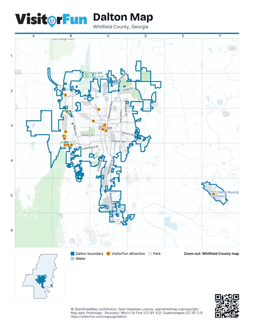
Street index of Dalton
Each street on the sheet and the grid squares it crosses.
- East Walnut AvenueC3, D3
- West Walnut AvenueB3, C3, B4, C4
- Chattanooga RoadB2
- North BypassB2, C2, D2
- North Glenwood AvenueC2, C3
- South BypassC6
- South Dixie RoadC3, C4
- South Glenwood AvenueC3
- Cleveland HighwayC2
- Abutment RoadC3, C4, C5, C6
- North Thornton AvenueB2, C2, C3
- East Morris StreetC3, D3
- South Thornton AvenueC3
- Airport RoadD3, F5
- West Morris StreetC3
- South Hamilton StreetC3, C4, C5
- Airport Road SoutheastF5
- Martin Luther King Jr BoulevardC3, D3
- North Tibbs RoadB2, B3
- Underwood StreetD2, C3, D3
- West Waugh StreetB3, C3
- College DriveB3
- Fields AvenueC2, C3
- North Hamilton StreetC2, C3
- Dug Gap Mountain RoadB3, A4, B4
- Emery StreetB3, C3
- West Crawford StreetB3, C3
- Shugart RoadB2, B3
- Dug Gap RoadB4
- North Selvidge StreetC2, C3
- West Tyler StreetB3, C3
- Riverbend RoadC3, C4, D4
- Legion DriveC2, D2
- South Tibbs RoadB3, B4
- Fleming StreetC2
- Pleasant Grove Drive NortheastD1, D2
- Hawthorne StreetC3
- 5th AvenueC3, C4
- Brickyard RoadC5
- West Hamilton AlleyC3
- Haigmill Lake RoadB1, B2
- West King StreetC3
- Willowdale Road NorthwestB2
- West Gordon StreetC3
- Willowdale RoadB2
- Haig Mill Road NorthwestB2
- East Tyler StreetC3
- West Emory StreetB3, C3
- Waring Road NorthwestC2
- North Pentz StreetC3
- South Selvidge StreetC3
- East Emory StreetC3
- Roberts StreetC3
- Foster RoadB5
- Walnut AvenueB3
- Mill Creek RoadA3
- Chattanooga AvenueC2, C3
- Callahan Road SoutheastC5
- Coronet DriveC2
- Rio Vista DriveB4
- Lakemont DriveB4, C4
- Threadmill RoadB4, C4
- Woods Point RoadA3
- Rocky Face CircleB2
- Broadrick DriveB2, B3
- Cuyler StreetB3, C3
- Botany Woods DriveB3
- Castle RoadB3
- Crow Valley RoadB1, B2
- Goose Hill RoadA3
- Jones StreetC3
- Vista DriveC2, D2
- Battlefield Park DriveA3, A4, B4
- South Green StreetC3, C4
- V D Parrott Jr ParkwayC3, C4
- Frazier DriveC2, C3
- Ella LaneB3
- Trammell StreetC2, C3
- Conway StreetC4
- South Goose Hill RoadA3
- Chatham DriveB1, B2
- Vernon AvenueB3, C3
- Mount Sinai StreetA3, B3
- Wood Valley DriveB3
- Industrial BoulevardC4
- Valley DriveC3
- Reed RoadC2
- George Rice DriveB3
- Sandy DunesC2, D2
- Manly StreetB3
- North Spencer StreetC3
- Clark StreetB3, C3
- Huntington RoadB3
- West Hawthorne StreetC3
- West Lakeshore Drive WestB4, C4
- Heather WayD1
- Central AvenueC4
- Underwood Road NortheastD2
- Brady DriveB2
- East Lakeshore DriveC4
- Riverbend DriveC4, D4
- Ryman Ridge RoadB4
- Brookhaven CircleB4, B5
- South Spencer StreetC3
- Mountain View StreetC2, C3
- Mitchell StreetC3
- North Summit DriveC1, C2
- Sheridan AvenueD3, D4
- Howell DriveC6
- Davidson DriveB3
- Morningside DriveC2
- Lisa LaneB3
- Suitcase Simpson DrB3
- Harris StreetC3
- Ridge StreetC3
- Nelson StreetC3, D3
- Kimberly Park DriveB2
- Greenwood PlaceC3, C4
- Cascade DriveB3, C3
- Burleyson RoadB2
- Beverly DriveB3
- Brooker DriveD2
- Brookhollow Road SoutheastC5, C6
- School StreetC3
- Ridgeleigh CircleB4
- West Franklin StreetC3
- Desota DriveB4, C4
- Professional BoulevardB2, C2
- Focus DriveC5, C6
- J and J DriveD2, D3
- Foster StreetC3, D3
- North Dogwood DriveD3
- Straight StreetC3
- Valencia DriveB4
- Marthas Bridge RoadB4
- Elaine WayB4
- Pinehill DriveD3
- Red Hill DriveC4
- East Franklin StreetC3
- Hair StreetC3, D3
- Hardwick CircleC3, C4
- Dawnville Road NortheastD1
- Railroad StreetC3
- May StreetC3, D3
- North Oaks DriveC2
- Elkwood DriveB2, B3
- 4th AvenueC3
- Briarcliff CircleB4
- McAfee StreetC3
- Mineral Springs RoadB4
- Belmont DriveB4
- Lewell StreetB3
- Virgil DriveC4
- Roan StreetC3, D3
- 3rd AvenueC3
- Lesley DriveC5
- South Pentz StreetC3
- North Park DriveC2
- Ridgefield WayB1, B2
- South Wildberry RoadA3
- Beechland CircleD3
- Brown StreetC3, C4
- South Grimes StreetC3, D3
- Autumn CourtC1
- Whitener DriveD3
- Harvard DriveB3
- Keen DriveC4
- Burchfield AvenueD3
- North Henderson StreetC3
- Southmont DriveB4
- Applewood DriveB2, B3
- Cedar StreetC4
- East Dug Gap Mt RoadB4
- Calhoun StreetC3
- Rainsong RoadB3
- Lester AvenueD3
- Canterbury Drive NorthwestB2
- North Elm StreetC3
- Robinwood DriveD3
- 11th AvenueD3
- Covie DriveB2, B3
- Fredrick StreetC3
- Linden DriveB4
- Meadowbrook Circle NorthwestB2
- North Grimes StreetC3
- North Grade DriveD3
- Fairfield DriveB4
- Martha Sue DriveD3
- Frances StreetC4
- Smith Industrial BoulevardC2
- Walston StreetB2, B3
- Dozier StreetC3, D3
- East Cuyler StreetC3
- Stacy DriveD3
- West Matilda StreetC3
- West Millstone CircleA3
- Cleo WayB2, C2
- Westerly DriveB3
- Lavert DriveC4
- Brighton WayC2
- Vann CircleD3
- Fairway DriveC2
- Atkinson DriveB3
- Ridgeview DriveB4
- Keith StreetD3
- McFalls StreetC2
- Moice DriveB2
- Woodland CircleC3
- David DriveB4, B5
- McGhee DriveD3
- Benton StreetC3
- New South Harris StreetC4
- Miller StreetC3
- Barbara StreetD3
- South Grade DriveD3
- Tiffany LaneB3
- Crescent StreetC4
- Bryant AvenueC4
- Northgate DriveC2
- Oxford StreetC3
- A Connector RoadD2
- Sherwood DriveB4
- JamesC3, D3
- Shields RoadB4
- Habersham WayB4
- Memorial DriveB2, C2
- Cappes StreetC3
- Willow Oaks DriveC2
- Northview DriveC3
- Needham DriveC4
- Altamont AvenueC4
- Fernwood AvenueC3
- Southview DriveB5
- Tibbs TerraceB3
- Mountain View DriveD3
- Tinsley StreetC2, C3
- Dee StreetC4
- Phillip DriveB2
- Brandywine WayB4
- Goodwill DriveD3
- Helton StreetC2, C3
- Stillwood DriveC3
- Rockdale DriveB4
- Wilding LaneB2
- Industrial South RoadC5
- Emmons DriveB3
- Gaston StreetC3, C4
- Learning WayC4
- West Boundry StreetC3
- Stoneleigh RoadC3, C4
- Coventry DriveB2
- Fairview DriveC3
- Edgewood AvenueC3
- Spruce StreetC4
- Maiden LaneC3
- Heritage CircleD2, D3
- Peek Road SoutheastC5
- New East Morris StreetC3, D3
- Avenue FC2, C3
- Loveman LaneB3
- Pinehill RoadD3
- E AvenueC2, C3
- Avenue CC2, C3
- Royal DriveC2
- West Environs LaneB2
- Juniper AvenueC3
- Summit House DriveC2
- Club DriveB2
- Byron StreetD3
- New Doris StreetC4, D4
- Springdale RoadC2
- Bear Creek RoadC5
- Civic DriveC2, C3
- St Charles StreetC4
- Croy StreetC3
- Red Clay AvenueC3
- Ross DriveB2
- Anthony AvenueB2
- Park Canyon DriveB3
- Terry LaneB3
- Bedford Drive NorthwestB1, B2
- Holly TerraceB2
- C.E. Whitener DrC3
- Delaware DriveC3
- Park StreetC2, C3
- Mosedale DriveD3
- Tarver StreetC3
- Georgian PlaceB3
- Tuftco DriveC4
- Calloway DriveC2
- Virginia AvenueC3
- Colorado DriveC2
- Connecticut DriveC3
- Oakmont DriveB4
- South DriveD3
- Red Wine StreetC3
- West Woodland DriveC3
- Dogwood LaneB3, C3
- Middle Summit DriveC1, C2
- Rocky LaneB2
Things to do on the Dalton map
Places on the map
- Academy Sports + Outdoors
- Adam's Tires
- Advance Auto Parts
- Al Rollings Park
- ALDI
- All Seasons Self Storage
- AMC CLASSIC Walnut Square 12
- America Carpet Wholesalers
- America's Best Contacts & Eyeglasses
- Applebee's
- Atlantic Capital Bank
- Baymont
- Big Lots
- Broaddus-Durkan Soccer Complex
- Christian Heritage School
- Civitan Park
- Dalton City Hall
- Dalton Civic Park
- Dalton Golf and Country Club
- Dalton High School
- Dalton Middle School
- Dalton Municipal Airport
- Dalton Post Office
- Fort Hill
- Hamilton Medical Center
- Heritage Point Park
- Lake Shore Park
- Lakeshores Lake
- Mount Rachel
- Northside
- Northwest GA Fairgrounds
- Park Creek Elementary
- Raisin Textiles
- Raisin Woods Mountain Bike Park
- Walking Path
- Wallnut Square Mall
- Walmart Supercenter
- West Hill Cemetery
- Whitfield Memorial Gardens
© OpenStreetMap contributors, Open Database License, openstreetmap.org/copyright · Map data: Protomaps · Boundary: Who's On First (CC-BY 4.0); Quattroshapes (CC BY 2.0)















