

Georgia map
Whitfield County map
About 105,070 people live here (Census Bureau, 2024 estimate). The sheet's index lists 300 streets; Chattanooga Road, Cleveland Highway and South Dixie Road cross the most grid squares. Things to do inside the boundary: Cafe Ostro, Cherokee Brewing + Pizza Company and Creative Arts Guild.
Open the map (PDF, US Letter)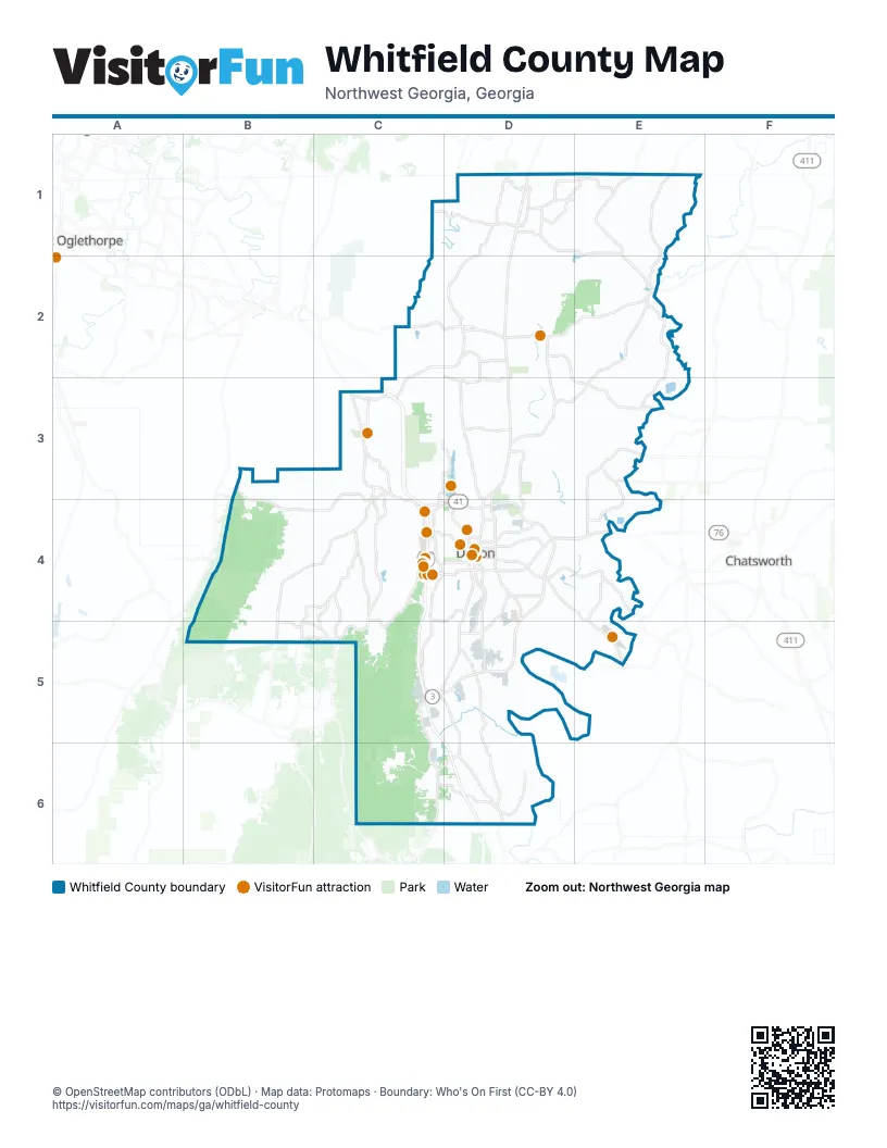
Maps inside Whitfield County
1 map inside, from the street map of Whitfield County down.
Street index of Whitfield County
Each street on the sheet and the grid squares it crosses.
- Chattanooga RoadC1, D1, C3, C4, D4
- Admiral Mack Gaston ParkwayD4, D5
- Cleveland HighwayD1, D2, D3, D4
- South Dixie RoadD4, C5, D5, D6
- South BypassC5, D5
- Cleveland RoadD1, D2, D3
- East Walnut AvenueD4
- Chatsworth Road SoutheastD4, E4
- South Dixie HighwayD6
- North BypassC4, D4
- West Walnut AvenueC4, D4
- North Glenwood AvenueD4
- South Dalton BypassC5, D5
- Fleming StreetD3, D4
- South Glenwood AvenueD4
- Dawnville Road NortheastD3, E3, E4
- Lafayette RoadC3, B4, C4, B5
- Prater Mill Road NortheastD2, E2
- Abutment RoadD4, D5
- Varnell RoadC2, D2, C3
- Tunnel Hill Varnell Road NorthwestC2, D2
- North Thornton AvenueD4
- East Morris StreetD4
- Airport RoadD4, E5
- Tunnel Hill Varnell RoadC2, C3
- North Varnell RoadC3
- Main StreetD2, C3, D4
- South Thornton AvenueD4
- South Spring StreetD2
- Tunnel Hill Church StreetC3
- West Morris StreetD4
- Georgia HighwayD2
- Hospital Access RoadD4
- Beaverdale Road NortheastE2, D3, E3
- Riverbend RoadD4, D5, E5
- Mill Creek RoadC3, C4, B5, C5
- Beaverdale Cohutta RoadD1, E1, E2
- Houston Valley RoadB3, C3, B4, C4
- Utility RoadB4, C4, B5
- Old Dixie Highway SoutheastD5, D6
- Dug Gap RoadC4, C5
- Waring Road NorthwestD3, D4
- River Road NortheastE2, E3
- Airport Road SoutheastD4, E4, E5
- Cohutta Varnell RoadD1, D2
- Hopewell RoadD1, E1
- South Hamilton StreetD4, D5
- Carbondale Road SouthwestC6, D6
- Hurricane RoadC4, C5
- Pleasant Grove Drive NortheastD3, D4
- Mitchell Bridge Road NortheastE3, E4
- Rauschenberg Road NorthwestC2, D2, D3
- Dug Gap Mountain RoadC4, C5
- Tibbs Bridge Road SoutheastE4
- Dug Gap Road SouthwestC5, C6
- Boyles Mill Road NortheastE3
- Martin Luther King Jr BoulevardD4
- Landfill RoadC4
- Lake Frances Road NortheastD2, D3
- Keith Valley RoadE1
- Hopewell LoopD1, E1
- Mount Pleasant Road NortheastE1, E2
- Old Chattanooga RoadC3
- Underwood StreetD4
- East Nance Spring Road SoutheastD6
- Mount Pleasant RoadE1
- Red Clay RoadD1
- Good Hope Road NortheastD2, D3, E3
- North Tibbs RoadC4
- Antioch RoadD4, D5
- Sam Love RoadC3, C4
- Haig Mill Road NorthwestC3, D3, C4
- Keith Mill Road SoutheastE4, E5
- Old Morris RoadC4, C5
- Williams Road NorthwestD3
- Seaton LoopD1
- West Waugh StreetC4, D4
- Old Dalton Cleveland HighwayD1
- West Nance Spring Road SouthwestC6, D6
- Emerson RoadE1
- Foster RoadC4, D4, C5, D5
- College DriveC4
- Wolfe StreetD1
- Fields AvenueD4
- Keith Valley Road NortheastE1
- North Hamilton StreetD4
- Tibbs Bridge RoadD4, E4
- Lyndsey Memorial RoadB5, C5
- Davis RoadC4, C5
- Emery StreetC4, D4
- Five Springs RoadD5
- West Crawford StreetD4
- Maple Grove Road NorthwestD3
- Shugart RoadC4
- Frontier Trail NorthwestD2
- Putnam RoadD1
- Wilson Caldwell RoadD1
- North Selvidge StreetD4
- Lowery LaneB5
- Haigmill Lake RoadC3, D3
- Brickyard RoadD5
- West Tyler StreetD4
- Legion DriveD4
- West Nance Spring RoadD6
- South Tibbs RoadC4
- Eastbrook Drive SoutheastD4
- Old Lafayette RoadC3
- North NEW Varnell RoadC3
- Hawthorne StreetD4
- 5th AvenueD4
- Witherow Bridge RoadE3
- Gazaway Road SoutheastD6
- Bradberry Hill RoadC4
- Willowdale Road NorthwestC4
- Oak StreetC3, D4
- Wagner DriveD4
- Willowdale RoadC4
- West Hamilton AlleyD4
- Kinnamon DriveD2
- West King StreetD4
- Stancil RoadD1
- West Gordon StreetD4
- Jordan StreetC3
- Trailblazer LaneD2, D3
- River Road CutoffE2
- East Tyler StreetD4
- West Emory StreetD4
- Antioch DriveD4
- Hardee RoadD6
- North Pentz StreetD4
- South Selvidge StreetD4
- Lower Mill Creek RoadC5
- Connector 3 SouthwestC5
- East Emory StreetD4
- Roberts StreetD4
- East Nickajack RoadB3
- Clement RoadB5
- Walnut AvenueC4
- Hill City Road NorthwestC6
- Dogwood StreetC3
- Hughes Lake Road SoutheastE1
- Reed RoadC2, D2, D3, D4
- Crow Valley RoadC2, C3, C4
- Old Ringgold RoadB3, B4
- Lake Katherine RoadC3
- Mount Vernon RoadC3, C4
- Prospect RoadE1, E2
- Nance Springs DriveD5, D6
- Ridge RoadD4, D5, E5
- Dawnville Beaverdale Road NortheastE3
- Renfroe Road NortheastD3, E3
- Sane Road SoutheastE4, D5, E5
- Bryant RoadD1
- New Hope Church RoadC2, D2, C3
- Old Grade RoadD4
- Apison Road NorthwestD1
- Redwine Cove Road SouthwestC6
- Mc Gaughey-Chapel Road NortheastD2
- Crow Road NortheastD2
- Lower Gordon Springs RoadB4, B5
- East Emerson RoadE1
- Wilson RoadD1, D2, D4
- Bowers Road NortheastE3
- Old Prater Mill Road NortheastD2
- Lee Bryant Road NortheastD2, E2
- Ledford RoadE1
- Cavender Road SoutheastD5
- Brown Road NortheastE2, E3
- Richardson Road NortheastE3, D4, E4
- Dunnagan RoadB4, C4
- Underwood Road NortheastD3, D4
- Lake Kathy RoadC2
- Lower Kings Bridge Road NortheastE3
- Callahan Road SoutheastD5
- Quarles RoadC4, C5
- Capehart RoadB3, B4
- Village DriveD2
- Riverdale Road NortheastE2
- Broadacre Road NorthwestD3
- Old Tunnel Hill RoadC1, D1
- Tate RoadB4
- Reed Pond Road NorthwestC3, D3
- Cedar Ridge Road SoutheastE4
- Hill RoadD4
- Parker Road SoutheastE4, C5, E5
- Cooper RoadE1
- Little Prospect RoadD2, E2
- Mountain View DriveC3, D4
- Dogwood Valley RoadB3, C3, B4
- Maddox Mill Road SoutheastE4
- Chattanooga AvenueD4
- Deep Springs Road NortheastE2
- Wheeler Dam RoadD1, D2
- Hickory Flat RoadD5
- Country WayD2
- East Haig Mill RoadD3
- Gordon Springs RoadB4
- Lower Dug Gap RoadC5, D5
- Miller Drive NortheastE4
- Dunn Road NortheastE2
- Standing RoadC2
- Bethel Church Road NortheastD4
- Trickum RoadB4
- Old Field Road SouthwestC5, D5
- Threadmill RoadD4
- Headrick Circle SoutheastD4
- Lowe RoadC2, D2
- Mc Camish Road NortheastD3, E3
- Old Tilton Road SoutheastD5
- Earnest RoadE1
- Old Cotton Mill RoadC3
- Mark Brown Road NortheastE3, E4
- Golf View DriveD2
- Strain RoadD2
- Cherokee Trail NorthwestD3
- Fennell Drive SouthwestD6
- Cline RoadD6
- Upper Varnell RoadD2
- Walt Maddron RoadE1
- Brock Road SoutheastD4, E4
- Brooker Road NortheastD3, D4
- Old Babb RoadC4
- Harris DriveC4
- Freeport Road NorthwestD3
- Tilton Road SoutheastD5, D6
- Vista DriveD4
- Cherokee Estate RoadD3, E3
- Maddox Chapel Road NortheastD4
- Brooker DriveD4
- Railroad StreetD2, D4
- Miller Road SoutheastD4, E4, D5, E5
- McGaughey Chapel RoadD1, E1, D2
- Poplar Springs Road NorthwestC3, D3
- Upper Ridge RoadD4, D5
- Peden Loop NortheastD2, E2
- Oscar Nance RoadC2, C3
- Lakemont DriveC4, D4
- Franklin Hill RoadC5
- Coronet DriveD4
- North Dug Gap RoadswC5
- Broadrick DriveD4
- Presley Road NortheastE3
- Boyd Road NortheastD2, E2
- Rio Vista DriveD4
- Ninety Seven Springs Road NortheastD3, E3
- Westbrook RoadD3
- Quinton RoadB4
- Old Tilton RoadD5
- Sourwood DriveC4, C5
- Sagamore DriveC2
- Cherokee Estate Road NortheastD3
- East Broadacre RoadD3
- Bryant CircleE2
- Old Rome RoadD5
- Crawford RoadB4
- Woods Point RoadC4
- Forester RoadC2, D2
- Blair RoadD1
- Hidden Lake RoadD3
- Scott RoadC1, C2
- Richardson DriveD4
- Rocky Face CircleC4
- LoganRoadB4
- Barnard RoadD2
- Cuyler StreetD4
- Collins Road SoutheastD4, D5
- Pleasant DriveD4
- Cottonwood Mill RoadC3
- Freeman Springs RoadB4, C4
- Botany Woods DriveC4
- Forest Hill Road SouthwestC5, D5
- West Jimmy DriveB4, B5
- Downing StreetD4
- Standifer RoadD1, D2
- Loftwood DriveD2
- Owen Road SouthwestC6
- Greeson DriveC4
- Highland Pointe DriveD2
- Mount Zion Road NortheastE3
- Baldwin RoadD1, E1
- Marla DriveD2
- Castle RoadC4
- Howell DriveD5
- Dover Street NorthwestD3
- Goose Hill RoadC4
- Jones StreetD4
- Peek Road SoutheastD5
- Wheat DriveD2
- Parrott RoadD1
- Wendell StreetD4
- Dantzler CircleD3
- Lakeview Drive SoutheastE4
- Battlefield Park DriveC4
- South Green StreetD4
- Wimpy RoadB3, B4
- Buckner RoadB3
- Pickens RoadB5
- Wilson LoopE1
- Crabtree DriveC2
- V D Parrott Jr ParkwayD4
Things to do on the Whitfield County map
Places on the map
- Al Rollings Park
- Barn Mountain
- Barrett Lake
- Barrett Lakes
- Blue Mountain
- Broaddus-Durkan Soccer Complex
- Chestnut Mountain
- Christian Heritage School
- Civitan Park
- Coahulla Creek High School
- Cobblestone Lake
- Cohutta
- Cohutta Elementary School
- Cohutta Park Walking Track
- Collins Lake
- Crown Mill Lake
- Dalton
- Dalton Golf and Country Club
- Dalton High School
- Dalton Municipal Airport
- Dalton Quarry
- Edwards Park
- Haig Mill Lake
- Haig Mill Lake Park
- Hamilton Medical Center
- Heritage Point Park
- Hiawassee Land Company Lake
- Hurricane Valley Estates Lake
- Lake Kathy
- Lakeshores Lake
- Leisure Lake
- Northwest GA Fairgrounds
- Pinhoti Horse Alternative
- Ridley Lake
- Rocky Face Ridge Park
- Tunnel Hill
- Tunnel Hill Golf Club
- Varnell
- Walking Path
- West Hill Cemetery
Next to Whitfield County
- Chatsworth
- Fort Oglethorpe
© OpenStreetMap contributors, Open Database License, openstreetmap.org/copyright · Map data: Protomaps · Boundary: Who's On First (CC-BY 4.0); Quattroshapes (CC BY 2.0)















