

Georgia map
Gwinnett County map
About 1,003,869 people live here (Census Bureau, 2024 estimate). The sheet's index lists 125 streets; Peachtree Industrial Boulevard, Buford Highway and University Parkway cross the most grid squares. Things to do inside the boundary: Explore Gwinnett.
Open the map (PDF, US Letter)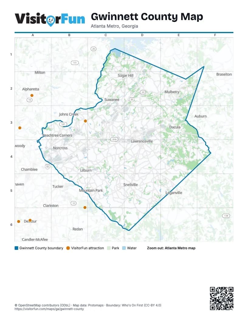
Street index of Gwinnett County
Each street on the sheet and the grid squares it crosses.
- Cumming HighwayC1, C2, D2
- Riverside RoadC1
- Suwanee Dam RoadC1, C2
- Buford Highway North EastD1, D2
- Buford Highway NortheastD1, D2
- Lanier ParkwayD1, D2
- Peachtree Industrial BoulevardD1, C2, D2, B3, C3, A4, B4
- Robert Bell ParkwayD1
- Buford HighwayC2, D2, B3, C3, A4, B4
- Buford Highway NorthwestC2
- Lawrenceville Suwanee Road NorthwestC2, C3, D3
- McGinnis Ferry RoadC2, C3
- McGinnis Ferry Road NorthwestC2
- Satellite Boulevard NorthwestC2, D2, C3, B4
- Suwanee Buford Dam RoadC2
- Suwanee Dam Road NorthwestC2
- Braselton HighwayD2, E2, D3
- Buford DriveD2, D3, D4
- Gainesville HighwayD2
- Gravel Springs RoadD2, E2
- Hamilton Mill RoadD2, E2
- I-85 Express Lanes ExtensionD2, E2
- Mall of Georgia BoulevardD2
- Nelson Brogdon BoulevardD2
- South Lee StreetD2
- Auburn RoadE2, E3
- Holcomb Bridge RoadA3, A4, B4
- Spalding DriveA3, B3
- Abbotts Bridge RoadB3
- Duluth HighwayB3, C3, D3
- Main StreetB3, D5
- Medlock Bridge RoadB3
- Medlock Bridge Road NorthwestB3, B4
- Old Norcross RoadB3, C3, B4, C4, D4
- Peachtree ParkwayB3
- Peachtree Parkway NorthwestB3, B4
- Pleasant Hill RoadB3, C3, C4
- Steve Reynolds BoulevardB3, B4, C4
- West Lawrenceville StreetB3
- I-85 Express LaneC3, C4
- Lawrenceville Suwanee RoadC3, D3, D4
- Old Peachtree RoadC3
- Old Peachtree Road NorthwestC3
- Satellite BoulevardC3, B4, C4
- Sugarloaf ParkwayC3, E3, C4, D4, E4
- University ParkwayC3, D3, E3, F3, C4, D4
- East Crogan StreetD3, D4
- Riverside ParkwayD3, D4
- Sweet Gum Road SoutheastD3
- Sweetgum RoadD3, D4
- West Pike StreetD3, D4
- Winder HighwayD3, E3
- Dacula RoadE3
- Harbins RoadE3, E4, F4
- Jimmy Carter BoulevardA4, B4, B5
- Winters Chapel RoadA4
- Beaver Ruin RoadB4, C4
- Indian Trail Lilburn RoadB4
- Indian Trail Lilburn Road NorthwestB4
- Indian Trail RoadB4
- Interstate Highway 85B4
- Killian Hill Road NorthwestB4, C4
- Langford Road NorthwestB4
- Lawrenceville HighwayB4, C4, D4, B5, E5
- Northeast ExpresswayB4
- Rockbridge RoadB4, B5, C5
- Singleton RoadB4
- South Norcross Tucker RoadB4
- Steve Reynolds Boulevard NorthwestB4, C4
- Tucker Norcross RoadB4
- Arcado RoadC4, C5
- Arcado Road NorthwestC4
- Arcado Road SouthwestC4
- Five Forks Trickum RoadC4, D4, C5
- Killian Hill RoadC4, C5
- Old Norcross Road NorthwestC4
- Ronald Reagan ParkwayC4, D4, D5
- Webb Gin House RoadC4, D4
- East Pike StreetD4
- Grayson HighwayD4
- Grayson ParkwayD4, D5
- Jackson StreetD4
- Lawrenceville-Suwanee RoadD4
- Loganville HighwayD4, D5, E5
- Martin's Chapel RoadD4, E4
- North Clayton StreetD4
- North Perry StreetD4
- North RoadD4
- Rosebud Road SouthwestD4, D5, D6
- Scenic HighwayD4, D5
- South Clayton StreetD4
- South Perry StreetD4
- Stone Mountain StreetD4
- West Crogan StreetD4
- Bold Springs RoadE4, F4
- Brooks RoadE4
- Brooks Road SoutheastE4
- Martins Chapel RoadE4
- Lilburn Stone Mountain RoadB5, C5
- Lilburn-Stone Mountain RoadB5
- Mountain Industrial BoulevardB5
- Rockbridge Road SouthwestB5, C5
- Annistown RoadC5, C6
- Bethany Church RoadC5
- Bethesda Church Road SouthwestC5
- Centerville HighwayC5, D5, C6
- East Park Place BoulevardC5
- Killian Hill Road SouthwestC5
- Main Street WestC5, D5
- Stone Mountain FreewayC5
- Stone Mountain HighwayC5
- West Park Place BoulevardC5
- Athens HighwayD5, E5
- Carpenter WayD5
- Civic Drive SouthwestD5
- East Main StreetD5
- Henry Clower BoulevardD5
- Henry Clower Boulevard SouthwestD5
- Knollwood Drive SouthwestD5
- Lenora Church RoadD5, D6
- Lenora Church Road SouthwestD5
- Main Street EastD5
- Scenic Highway SouthD5
- Atlanta HighwayE5
- Lawrenceville RoadE5
Things to do on the Gwinnett County map
Places on the map
- Alcovy Trace
- Alcovy Village
- Alexander Park
- Allen Lake
- Almont Farms
- Amber Hills
- Amberleaf
- Amelia Grove
- Ancroft Circle
- Ansley Brook
- Apalachee Hills
- Appalachee River Club
- Arbor Brook
- Archer High School
- Arlington Point
- Arnold Lake
- Ashland Park
- Ashley Trace
- Ashmore Lake
- Ashton Place
- Avington Glen: The Arbors
- Avington Glen: The Enclave
- Bailey Fence - Taylor Morrison
- Bear's Best Atlanta
- Beckett Ranch
- Bennett Farm
- Berkeley Hills Country Club
- Berkeley Lake
- Berkmar High School
- Berry Lake
- Bethesda Cove
- Bethesda Heights
- Bethesda Park
- Blue Linx
- Bogan Park
- Bowman Meadows
- Bowmans Island
- Brandon Square
- Brandywine on the River
- Brays Mill
Next to Gwinnett County
- Alpharetta
- Auburn
- Braselton
- Candler-McAfee
- Chamblee
- Clarkston
- Decatur
- Doraville
- Dunwoody
- Johns Creek
- Loganville
- Milton
- Redan
- Tucker
© OpenStreetMap contributors (ODbL) · Map data: Protomaps · Boundary: Who's On First (CC-BY 4.0)