

Georgia map
Hall County map
About 221,745 people live here (Census Bureau, 2024 estimate). The sheet's index lists 76 streets; Lanier Parkway, Lula Road and Mount Vernon Road cross the most grid squares. Also on it: Agile Cold Storage, Alta Vista Cemetery and Associated Asphalt.
Open the map (PDF, US Letter)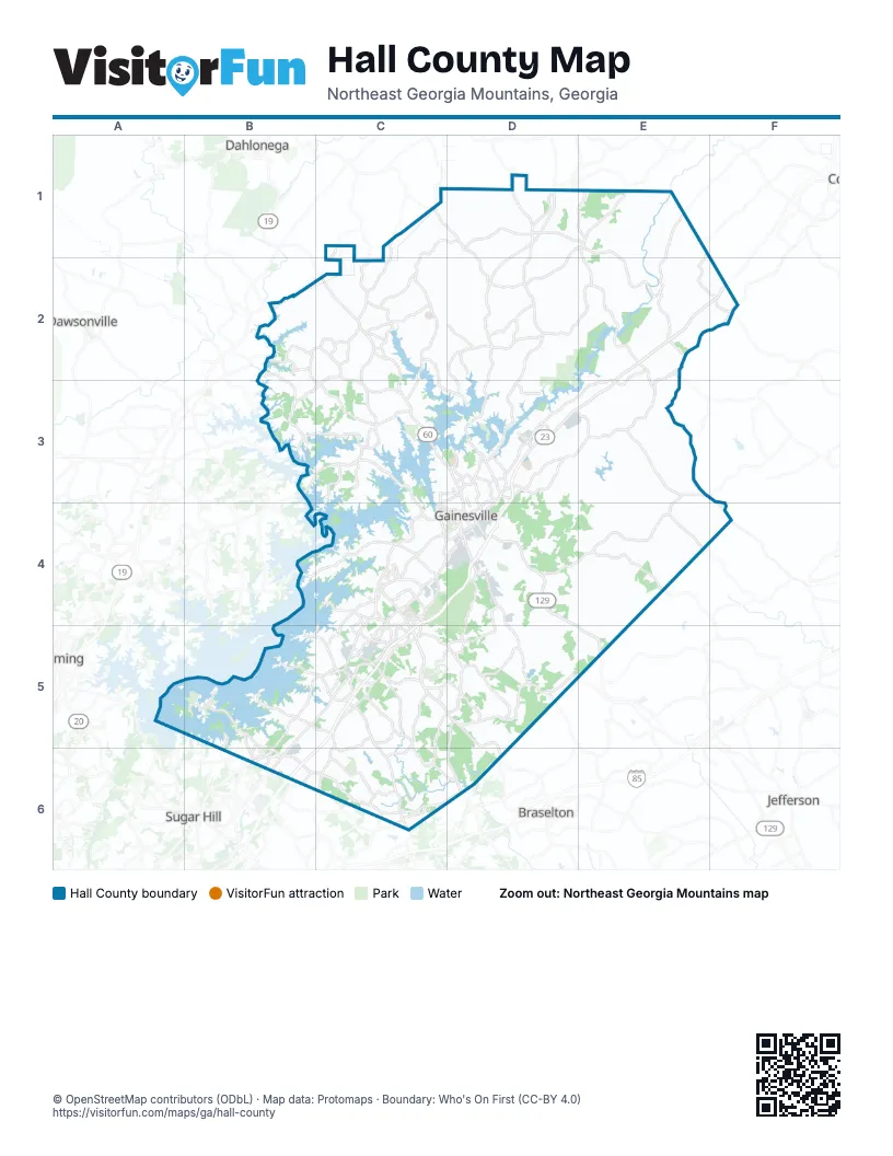
Street index of Hall County
Each street on the sheet and the grid squares it crosses.
- Dahlonega HighwayC1, D1, D2
- Mount Vernon RoadC1, D1, C2, C3
- Clarks Bridge RoadD1, D2, D3
- Clermont HighwayD1
- Cleveland HighwayD1, D2, D3
- Dean StreetD1
- Highway 284D1
- Holly Springs RoadD1, E1, E4
- King StreetD1
- Lula RoadD1, E1, D2, E2, E3
- Main StreetD1, E2, E3
- Old Cleveland RoadD1
- Shoal Creek RoadD1
- Price RoadB2, C2, C3
- Old Dahlonega HighwayC2
- Thompson Bridge RoadC2, C3, D3
- Brookton Lula RoadD2
- Athens StreetE2
- Cornelia HighwayE2, F2, D3, E3
- Homer RoadE2
- Moon DriveE2
- Old Cornelia HighwayE2, F2, D3, E3
- Gainesville HighwayF2, B5, C5, B6
- Dawsonville HighwayB3, C3, C4
- Ledan RoadC3
- Lynncliff DriveC3
- Sardis RoadC3
- Branch StreetD3, D4
- Chiplan RoadD3
- Downey BoulevardD3, D4
- Green Street NortheastD3, D4
- Jesse Jewell ParkwayD3, D4
- Jesse Jewell Parkway NortheastD3
- Jesse Jewell Parkway SoutheastD3, D4
- Lanier ParkwayD3, C4, D4, C5, B6, C6
- Limestone ParkwayD3
- Morningside DriveD3
- Park Hill DriveD3
- Ramsey RoadD3
- Riverside DriveD3
- South Enota Drive NortheastD3
- Gillsville HighwayE3, D4, E4
- Browns Bridge RoadB4, C4, D4
- Atlanta HighwayC4, C5
- Atlanta RoadC4, D4
- John W Morrow ParkwayC4, D4
- McEver ExtendedC4
- McEver RoadC4, B5, C5, B6
- Millside ParkwayC4
- Mundy Mill RoadC4, C5
- Pearl Nix ParkwayC4, D4
- Thurmon Tanner ParkwayC4, C5
- Tumbling Creek RoadC4
- Athens HighwayD4, E5
- E. E. Butler ParkwayD4
- Jesse Jewell Parkway SouthwestD4
- Martin Luther King Jr BoulevardD4
- Myrtle Street WestD4
- Queen City ParkwayD4
- State Route 60D4, D5
- Falcon ParkwayC5
- Phil Neikro BoulevardC5
- Poplar Springs RoadC5, D5
- Spout Springs RoadC5, C6
- Thurmond Tanner RoadC5
- Winder HighwayC5, D5
- Old Winder HighwayD5, D6
- State Road 60D5
- Tanners Mill RoadD5
- Buford Highway North EastB6
- Buford Highway NortheastB6
- Friendship RoadB6, C6, D6
- Holiday RoadB6
- Peachtree Industrial BoulevardB6
- Thompson Mill RoadC6
- Friendship DriveD6
Places on the map
- Agile Cold Storage
- Alta Vista Cemetery
- Associated Asphalt
- Big Gaines Ferry Island
- Big Junction Island
- Bolding Mill Campground
- Bolding Mill Day Use Park
- Brannon Ridge
- Burton Mill Park
- Cargill
- Chattahoochee Golf Course
- Cherokee Bluffs Park
- Chestatee High School
- Chicopee Woods Golf Course
- Chicopee Woods Nature Preserve
- Clermont
- Concord Circle
- Cottrell Trailers
- Coyote Loop
- Dockside Shoals
- Don Carter State Park
- Ducket Mill
- Eskimo Cold Storage
- Fieldale Farms
- Flat Creek Island
- Flowery Branch
- Friendship Quarry
- Gainesville
- Gainesville Middle School
- Gainesville Quarry
- Gainesville Quarry Lake
- Gillsville
- Hall County
- Hall County Landill
- Hall County Quarry
- Holiday On Lake Lanier
- Lake Lanier Sailing Club
- Lake Shore Circle
- Lanier Luxe
- Latham Island
Next to Hall County
- Braselton
- Buford
- Cumming
- Dahlonega
- Dawsonville
- Jefferson
- Sugar Hill
© OpenStreetMap contributors (ODbL) · Map data: Protomaps · Boundary: Who's On First (CC-BY 4.0)