

Georgia map
Northeast Georgia Mountains map
The sheet's index lists 33 highways; GA 15, GA 17 and US 23 cross the most grid squares. Things to do inside the boundary: Amicalola Falls State Park, Anna Ruby Falls and Babyland General Hospital. Also on it: Auburn, Braselton and Clayton.
Open the map (PDF, US Letter)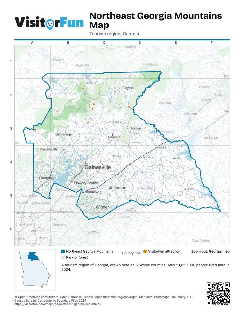
Highway index of Northeast Georgia Mountains
Each highway on the sheet and the grid squares it crosses.
- I-85B5, C4, C5, D4, E3, E4
- I-985B4, B5
- US 19A4, A5, B1, B2, B3, B4
- US 23B4, B5, C3, C4, D1, D2, D3
- US 29B5, C5, C6
- US 76A2, B1, B2, C1, C2, D2
- US 123D3
- US 129B1, B2, B3, B4, C4, C5, D5
- US 441C3, C4, D1, D2, D3, D4, D5
- GA 2A2, B1, B2, C1, C2, D2
- GA 8C5, C6
- GA 9B3
- GA 11B1, B2, B3, B4, C4, C5
- GA 15C3, C4, C5, D1, D2, D3, D4, D5
- GA 17B1, C1, C2, D3, D4, E4, E5, F5
- SR 17E5
- GA 20A5, B5
- GA 51E4
- GA 52B3
- GA 60B3, B4
- GA 72D5, E5, F5
- SC 72F5
- SR 72E5
- GA 75C1, C2
- GA 105C3
- GA 141A5
- GA 164C4
- GA 180B2
- GA 184D3
- GA 316B5, C5, C6
- GA 365B4, C3, C4, D3
- GA 400A4, A5, B3, B4
- GA 515A2, B1, B2
Things to do on the Northeast Georgia Mountains map
- Amicalola Falls State Park
- Anna Ruby Falls
- Babyland General Hospital
- Black Rock Mountain State Park
- Brasstown Bald
- Crawford W. Long Museum
- Currahee Military Museum
- Dahlonega Gold Museum State Historic Site
- Loudermilk Boarding House Museum
- Screaming Eagle Ziplines
- Smithgall Woods Conservation Area
- Tallulah Gorge State Park
- Traveler's Rest State Historic Site
- Ty Cobb Museum
- Unicoi Zipline and Aerial Adventure Park
- Vogel State Park
Places on the map
- Auburn
- Braselton
- Clayton
- Cornelia
- Cumming
- Dahlonega
- Dawsonville
- Flowery Branch
- Gainesville
- Jefferson
- Lavonia
- Toccoa
- Winder
Next to Northeast Georgia Mountains
- Atlanta Metro map
- Classic South map
- Historic Heartland map
- Northwest Georgia map
- Smoky Mountains & Cherokee
- Lake Hartwell Country
- The Old 96 District
© OpenStreetMap contributors, Open Database License, openstreetmap.org/copyright · Map data: Protomaps · Boundary: U.S. Census Bureau, Cartographic Boundary Files 2024