

Georgia map
Woodstock map
About 39,381 people live here (Census Bureau, 2024 estimate). The sheet's index lists 300 streets; Highway 92, Main Street and Woodstock Parkway cross the most grid squares. Things to do inside the boundary: The Outlet Shoppes at Atlanta.
Open the map (PDF, US Letter)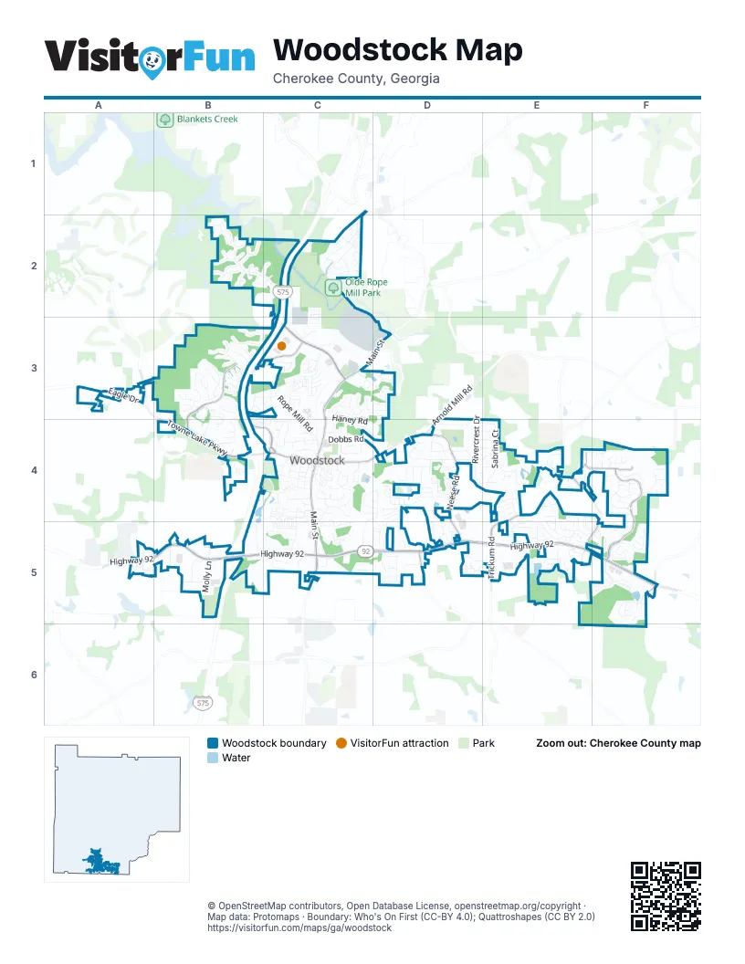
Street index of Woodstock
Each street on the sheet and the grid squares it crosses.
- Phillip Landrum Memorial HighwayB5
- Northwest Corridor Express LanesB5
- Highway 92A5, B5, C5, D5, E5, F5
- Main StreetC3, D3, C4, C5
- Towne Lake ParkwayA3, B4, C4
- Woodstock ParkwayB3, C3, B4, C4
- Ridgewalk ParkwayC3
- Arnold Mill RoadC4, D4
- Old Rope Mill RoadC2, C3
- Woodlands ParkwayF4, F5
- Running Deer ParkwayB3, B4
- Trickum RoadE4, E5
- Neese RoadD4, D5
- Ragsdale RoadE4, E5, F5
- Celadine PlaceE4, F4
- Wigley RoadF5, F6
- Persimmon TrailE4
- Eagle DriveA3
- Hames RoadD5
- Ford ParkwayC4
- West Wylie Bridge RoadF5
- Brooke BoulevardD3
- Rope Mill RoadC2, C3, C4
- Dream Catcher DriveB3
- Lakestone ParkwayE5
- Windsong WayC4
- Ashland ParkwayB2, C2
- Edinburgh LaneD4
- Chatley WayD4, D5
- Sabrina CourtD4, E4
- Rivercrest DriveD4, E4
- Springfield DriveC4, D4, C5
- Dunedin TrailE4
- Johnston Farm LaneC3, D3
- Ridge TrailC3
- Park AvenueD4
- Washington AvenueD4
- Willow Creek LaneD5, E5
- River Park BoulevardC2
- Weatherstone PlaceE5
- Stoneforest DriveB3, B4
- Haney RoadC3, C4, D4
- Dawson DriveC4, C5
- Molly LaneB5
- Ridge ValleyB3
- Bell Park DriveC2, C3
- Hunters RidgeB3
- Highlands LoopF5
- Balaban CircleF5
- Dupree RoadC4
- Weatherstone DriveE4, E5
- Reeves StreetC4, C5
- Towey TrailF4
- Parkway 575B4, B5
- Buckhead CrossingB3, B4
- Walnut Hall CircleB2
- Stone Bridge ParkwayB4
- Cornerstone CircleE4, F4, E5, F5
- Dobbs RoadC4
- Grand Oaks DriveD4
- Bentley ParkwayC4
- Sycamore LaneD5, E5
- Elena WayC3
- Georgia WayC2
- Churchcliff DriveF5
- Sandy CircleC4
- Moccasin TrailB3
- Commons AvenueB3, B4, C4
- Hubbard RoadC4
- Windfields LaneC3
- Avonlea PlaceB4
- Brighton BoulevardC4
- Lincoln StreetC3
- River Park Drive NorthC2
- Woodglen DriveC4, C5
- Towne Lake HeightsB3, B4
- Parks CircleC4
- Village TraceE5
- Radford CircleD4, D5
- Driftwood LaneD4, E4
- Acuba ViewE5
- Justin DriveD4, D5
- Santa Anita AvenueB2
- Franklin RoadD4
- Hiawassee DriveC2
- Mountain Brook ParkwayF5
- Fowler StreetC4
- Susobell PlaceF4
- Swanee LaneC2
- Winchester WayC4, D4
- Rokeby DriveD4
- Independence WayD4
- South Club DriveC4
- Nacotee TrailE4
- Weatherstone Pointe DriveE4, E5
- Sumac TrailF4
- Market StreetC4
- Creekstone RidgeC5
- Spotted Ridge CircleD3
- Abbey CircleE4, E5
- Brittania CircleD5
- Rusk StreetC4
- Big Rock WayC3
- Sherwood DriveC4
- Claremore DriveE5
- Lakeview ParkwayF5
- Lanier CircleA5
- Revillion WayF4
- Regent SquareE4
- Glens WayF5
- Londonderry DriveD5
- Brookview PlaceF5
- Laurelwood DriveC5
- Paces ParkwayB3, B4
- Bevington LaneE5
- Santa Anita DriveB2
- Hathaway RoadC4, D4
- Indian Valley DriveC5
- Magnolia Leaf DriveC3
- Bendleton DriveF4
- Piedmont LaneB3
- Woodstock Square AvenueB5
- Normandy DriveF5
- Melrose CircleD4
- Mill StreetC4
- Cousins RoadC4
- Regent PlaceE4
- Brandon StreetC3
- Long DriveB5
- Overhill DriveB3
- Cornerstone PlaceF5
- Hamilton StreetD4
- Chandler LaneC4, C5
- Tallapoosa TrailC2
- East Main StreetC4
- Robinhood DriveC4
- Stone Manor CourtE4, F4
- Mountain View LaneF5
- Professional ParkwayC5
- Smoke Hill LaneD5
- South Cherokee LaneE5
- Keeneland AvenueB2
- Barnsdale TerraceC4
- Morning Mist LaneC4
- Goshen LaneC4
- Watercress DriveF4
- Pinehill DriveC4
- Village TrailD5
- Dahoma TrailE4
- Brentwood LaneD4
- Harvest View TerraceC3, D3
- Brashy StreetC5
- Brendylynn TraceF4
- Oakbourne WayC3
- Kyle StreetC4
- Society CourtC3
- Serenade LaneC4, C5
- Melanie LaneC4
- Old Deerfield LaneB3
- Abercorn WayE5
- Burdock TraceE4, F4
- Village ViewD5
- Cardinal DriveB3, C3
- Cornerstone DriveF5
- Chambers StreetC4
- Yorkshire LaneD5
- Greenberry LaneC5
- Linton StreetC4
- Gunnin RoadE4, E5
- Cottonwood LaneC4, C5
- Grand Oaks LaneD4
- Atkins LaneB3, B4
- Hayden CircleA5
- Ravenwood DriveB3
- Briar Hollow LaneC3, D3
- Winthrope DriveC3
- Kigian TrailE4
- Stonecroft LaneC5
- Woodpark PlaceC5
- Jefferson DriveD4
- Rope Mill LaneB3, C3
- Downsby LaneA5
- Flintrock WayC3
- McAffee StreetC4
- Alcovy WayC2
- Hickory Ridge TrailD5
- Whitfield WayC3
- Skyridge DriveC5
- Victoria LaneB4
- Doris DriveD4, E4
- Parkstone LaneB3, B4
- Tyler DriveF5
- Finsbury LaneE4
- Lazarus DriveF4
- Brownlee RoadB3, C3
- Waveland DriveB2
- Paden StreetC4
- Ridge Crossing DriveB3
- Ashland DriveB2
- Meadow Mill RoadC3
- Meridian DriveC3
- Oconee PassC2
- Emma DriveB5
- Santa Anita TrailB2
- Ridge View CrossingC2
- Hickory StreetC4
- South On Main DriveC5
- Quinn DriveC3
- Horsehoe BendB3
- Carriage Glen LaneC2, C3
- Heritage WalkC5
- Bedford CourtC5, D5
- Grafton WalkD4
- Middleton PassD4
- Song Bird WayC4
- Nottingham DriveC4
- Bell ParkwayC3, D3
- Maple StreetC4
- Chatooga LaneC2
- Floral Valley RoadC3
- Arden CloseC3
- Parkstone DriveE4, E5, F5
- Aucilla LaneE4
- Hillside TrailF5
- Manley CourtC5, D5
- Lorraine ParkwayC3
- Chambers DriveC5
- Glens LoopF5
- Citronelle DriveE4
- Ivory TrailD4, D5
- Towne Ridge WayC3
- Dritton WayE4
- Mullen TraceF4
- Latimer StreetC4
- Glens DriveF5
- Lakestone OverlookE5
- Woodpark BoulevardC5
- Papillion TraceF4
- Village Centre EastE5
- Putnam Ford DriveA3
- Neese Farm DriveD4, E4
- Wickley WayF5
- Remington CourtC4, D4
- Londonderry CourtD5
- North Rope Mill RoadC2
- Creekwood DriveC4
- Mountain CrossingF5
- Dean StreetC3, C4
- Heritage RowD4
- Mountain DriveF5
- Lakestone LandingE5
- Village Square DriveE5
- Revere DriveD4
- Riverton WayB3, C3
- Alley CC2
- The Crossing LaneB3
- Dahlia DriveD5
- Gainesway ParkB2, C2
- Bear Cave TrailB3
- Gold Creek TrailE5
- Hidden CloseF5, F6
- Thaxton LaneC3
- Village Centre WestE5
- Churchill CourtD5
- Loraine ParkwayC3
- Cabin Creek CourtB3
- Falcon CourtC3
- Great Pine WayC2, C3
- Pearl StreetC4
- Pin Oak AvenueC2
- Freelon LaneC3
- Paces LaneB3, B4
- Keeneland TerraceB2
- New Echota WayB3
- Antebellum PlaceC3
- Commonwealth DriveD5
- Turnstone DriveE5
- Village Centre DriveE5
- Clay StreetC4
- Honey Springs DriveB3
- Parkridge DriveB4
- Tuggle CourtC3
- Parkbrooke CircleA3
- Ann CourtD4, E4
- Elkhorn PlaceB2
- Pinchot WayF4
- Cotton Gin DriveC3
- Cinema WayB4
- Highland DriveD3
- Norton CrossingC3
- Tippin TrailD4
- Travis CourtC3
- Cristy LaneE4
- Finch CourtB3, C3
- Mill Park ChaseC3
- Gainesway DriveC2
- Gainesway TrailB2
- Lakestone DriveE5
- Summer CourtE4
- Walnut Hall TrailB2
Things to do on the Woodstock map
Places on the map
- 8744 Main Street
- Advance Auto Parts
- ALDI
- All American Tool & Party Rental
- Allen Temple African Methodist Episcopal Church
- AMF Woodstock Lanes
- AutoZone
- Avalanche Trail (Intermediate)
- B & P Tire And Automotive Repair
- Bank of America
- Bank OZK
- Benton House
- BJ's Wholesale Club
- Bojangles'
- Bullock's Wine & Spirits
- Camping World
- Checkers
- Cherokee County Station 14 Woodstock Fire Station
- Cherokee Golf Center
- Chevron
- Chili's
- Circle K
- Circuit Woodstock
- Colony Land Development Lake
- Costco
- Creekstone Office Park
- Dupree Park
- Enon Cemetery
- First Baptist Church Woodstock
- Gordy Lake
- Ivy Village Professional Park
- Olde Rope Mill Park
- The Outlet Shoppes at Atlanta
- The UPS Store
- The Village at Trickum
- Walmart Supercenter
- Woodstock City Church
- Woodstock Crossing
- Woodstock Park & Ride
- Woofstock Park
© OpenStreetMap contributors, Open Database License, openstreetmap.org/copyright · Map data: Protomaps · Boundary: Who's On First (CC-BY 4.0); Quattroshapes (CC BY 2.0)















