

Georgia map
Cherokee County map
About 293,513 people live here (Census Bureau, 2024 estimate). The sheet's index lists 48 streets; Cumming Highway, Fincher Road and Ball Ground Highway cross the most grid squares. Things to do inside the boundary: The Outlet Shoppes at Atlanta.
Open the map (PDF, US Letter)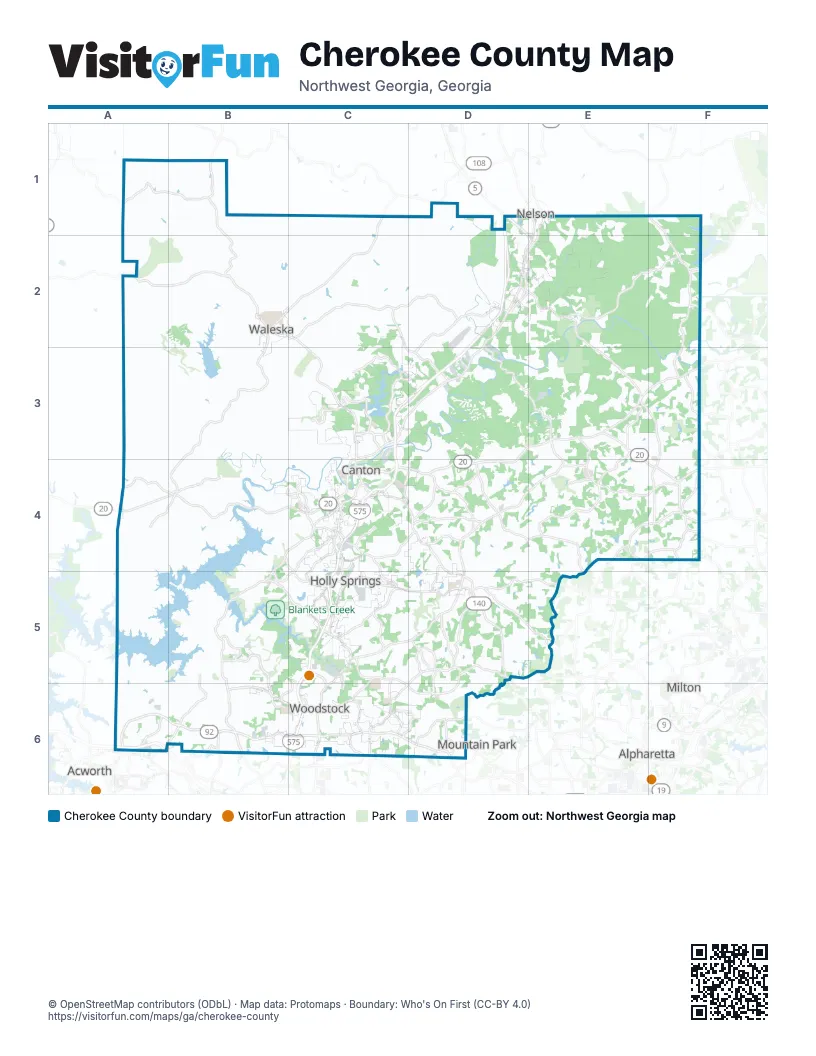
Street index of Cherokee County
Each street on the sheet and the grid squares it crosses.
- Fincher RoadC1, B2, C2, B3, B4
- A P D HighwayD1, D2, C3, D3
- Ball Ground HighwayE1, D2, E2, C3, D3
- Canton RoadE1
- Reinhardt College ParkwayA2, B2, C2, C3
- Waleska HighwayA2
- A. W. Roberts DriveD2
- Canton HighwayD2, A4, F4
- Gilmer Ferry RoadD2, E2
- Howell Bridge RoadD2
- Ball Ground RoadE2, E3, F3, F4
- Bluffs ParkwayC3
- Marietta HighwayC3, C4
- Phillip Landrum Memorial HighwayC3, D3, C4, C5, C6
- Riverstone BoulevardC3
- Riverstone ParkwayC3
- Waleska RoadC3
- Waleska StreetC3, C4
- Airport DriveD3
- Cumming HighwayD3, E3, C4, D4, E4, F4
- Hightower RoadE3, F3
- Matt HighwayF3
- Knox Bridge HighwayA4, B4, C4
- Bells Ferry RoadB4, C4, B5, B6
- East Main StreetC4
- Hickory Flat HighwayC4, D4, D5
- Hill StreetC4
- Holly Springs ParkwayC4, C5
- North StreetC4
- West Main StreetC4
- Birmingham HighwayE4
- Birmingham RoadE4, F4
- Freehome HighwayF4
- Towne Lake ParkwayB5, B6, C6
- Arnold Mill RoadC5, D5, C6, D6
- Hickory RoadC5, D5
- Main StreetC5, C6
- Northwest Corridor Express LanesC5, C6
- Old Rope Mill RoadC5
- Ridgewalk ParkwayC5, C6
- Sixes RoadC5
- Woodstock ParkwayC5, C6
- Alabama RoadA6, B6
- Cherokee RoadA6
- Larry McDonald Memorial HighwayA6
- Bells Ferry Road NorthwestB6
- Highway 92B6, C6, D6
- Wade Green RoadB6
Things to do on the Cherokee County map
Places on the map
- Allatoona Lake
- Almond Lake
- Ansley Golf Club - Settindown
- Ashley Hall
- Atlanta Gas Light Lake
- Atlanta National Golf Club
- Avalanche Trail (Intermediate)
- Badger Creek Park
- Ball Ground
- Ball Lake
- Ballground Quarry
- Black Horse Circle
- Blankets Creek
- Bloomfield Circle
- Bradshaw Lake
- Brayden Park
- BridgeMill Athletic Club
- Brookwood and Darby Road
- Cadence
- Cagle Lake
- Callahan Golf Links
- Canton
- Canton Golf Club
- Carmichael Circle
- Cherokee County
- Cherokee High School
- Cherokee LNG Plant
- Cherokee Quarry
- Cherokee Reserve Circle
- Cherokee Veterans Park
- Chickasaw Lake
- Claremore Manor
- Cline Lake
- Creekview High School
- Dean Lake
- Deer Run West
- Eagle Watch Golf Club
- Etowah River
- Etowah River Park
- Fairways of Canton
Next to Cherokee County
- Acworth
- Alpharetta
- Milton
- Mountain Park
- Nelson
© OpenStreetMap contributors (ODbL) · Map data: Protomaps · Boundary: Who's On First (CC-BY 4.0)