

Iowa map
Council Bluffs map
About 62,665 people live here (Census Bureau, 2024 estimate). The sheet's index lists 300 streets; East Kanesville Boulevard, South 35th Street and Valley View Drive cross the most grid squares. Things to do inside the boundary: Hoff Family Arts & Culture Center and Pottawattamie County Jail.
Open the map (PDF, US Letter)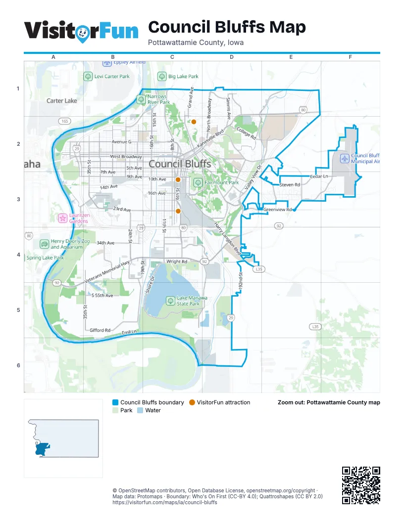
Street index of Council Bluffs
Each street on the sheet and the grid squares it crosses.
- East Kanesville BoulevardD1, E1, C2, D2
- West Veterans Memorial HighwayB4, C4, A5
- West BroadwayA2, B2, C2
- South ExpresswayC2, C3, C4
- North 16th StreetC1, C2
- State Highway 92D4
- Veterans Memorial HighwayA4, A5
- South 7th StreetC2, C3
- East Veterans Memorial HighwayC4, D4
- South 6th StreetC2, C3
- US Highway 6E1
- West Kanesville BoulevardC2
- East BroadwayC2, D2
- North 6th StreetC2
- North 7th StreetC2
- 23rd AvenueB3, C3
- South 35th StreetB2, B3, B4, B5
- Avenue GA2, B2, C2
- Valley View DriveD2, E2, D3, D4
- Harry Langdon BoulevardC3, D3, D4
- South 24th StreetB2, B3, B4
- 5th AvenueA2, B2, C2
- 9th AvenueA3, B3, C3
- McPherson AvenueD2, E2, F2
- College RoadE1, D2, E2
- Madison AvenueC2, D2, D3
- South 8th StreetC2, C3
- North 8th StreetC1, C2
- South 16th StreetC2, C3
- North BroadwayD1, D2
- Bennett AvenueD2, D3
- East Pierce StreetC2, D2
- Harrison StreetC1, C2
- Railroad HighwayD1, E1
- South Main StreetC2, C3
- South 3rd StreetC2, C3
- Woodbury AvenueD3
- Nebraska AvenueA3, B3
- Bluff StreetC2, C3
- South 1st StreetC2, D2
- Pearl StreetC2, C3
- Willow AvenueC2
- North 1st StreetC2
- Wabash AvenueD4
- West Pierce StreetC2
- North AvenueD2
- North Main StreetC2
- Gifford RoadB4, B5
- Avenue BA2, B2, C2
- 2nd AvenueA2, B2, C2, C4
- Avenue AA2, B2, C2
- Franklin AvenueC2, D2, D3, E3
- Eastern Hills DriveF2, E3, F3
- South 11th StreetC2, C3, C4
- South Shore DriveC5, D5
- 34th AvenueB4, C4
- East Manawa DriveC4, D4, D5
- Indian Hills RoadD1, D2
- 16th AvenueB3, C3
- Avenue LB2, C2
- West Shore DriveC4, C5
- South 19th StreetC2, C3, B4, C4
- 32nd AvenueB4, C4
- Twin City DriveB4
- South 21st StreetB2, B3, B4, C4
- Simms AvenueD1, D2
- River RoadA3, A4
- North 25th StreetB2
- Steven RoadE3
- Greenview RoadD3, E3
- 35th AvenueB4, C4
- Southbound Frontage RoadA2, A3
- 192nd StreetD4, D5
- Cedar LaneE3, F3
- Northbound Frontage RoadA2, A3
- South 55th AvenueB5
- Nash BoulevardB1, C1, B2
- South 32nd StreetB2, B3
- North 21st StreetB2
- Lincoln AvenueD2
- North 28th StreetB2
- Big Lake RoadC1
- Graham Avenue WestC3, D3
- Gleason AvenueD2
- Metro DriveC4, D4
- State Orchard RoadE3
- McKenzie AvenueD1
- North 32nd StreetB2
- South 4th StreetC2, C3
- 19th AvenueC3
- East South Omaha Bridge RoadD4
- Bonham StreetD2
- North 35th StreetB2
- Grand AvenueC1
- High StreetC3
- Navaho StreetC5, D5
- South 25th StreetB2, B3
- South 28th StreetB2, B3
- Spencer AvenueD1
- Longview DriveD3
- Joslin AvenueC1
- North 40th StreetA2
- Mall DriveD3
- West Washington AvenueC2
- Graham Avenue EastD2, D3
- West Graham AvenueD2, C3
- Marshal AvenueC1, C2
- Morgan StreetC1
- Mynster Springs RoadC1
- 40th StreetA2
- Avenue DA2, B2, C2
- Avenue CA2, B2, C2
- 14th AvenueB3, C3
- 6th AvenueA2, B2, C2
- 3rd AvenueA2, B2, C2, C4
- 7th AvenueA3, B3, C3
- 8th AvenueA3, B3, C3
- Avenue EA2, B2, C2
- 4th AvenueA2, B2, C2
- Avenue FA2, B2, C2
- South 9th StreetC2, C3, C4
- South 13th StreetC2, C3, C4
- 10th AvenueB3, C3
- South 10th StreetC2, C3
- South 12th StreetC2, C3
- Avenue IB2, C2
- Avenue HB2, C2
- South 17th StreetC2, C3
- Mid-America DriveB3
- Avenue JB2, C2
- North 15th StreetC1, C2
- Navajo StreetC4, C5, D5
- 24th AvenueB3, C3
- Marketplace DriveB4
- South 29th StreetB2, B3
- Yellow Pole RoadE1
- Parkwild DriveC1, C2
- North 25th ExtensionB1, C1, B2
- 29th AvenueC3, D3
- 15th AvenueC3
- South AvenueC3, D3
- Avenue KB2, C2
- South 15th StreetC2, C3
- North 17th StreetC2
- 28th AvenueC3
- Beacon LaneD5
- Council Pointe RoadB4, B5
- North 22nd StreetB2
- Iowa Western BoulevardE2
- 12th AvenueB3, C3
- South 34th StreetB2, B3
- South 18th StreetC2, C3
- North 10th StreetC2
- Iowa School for Deaf DriveD4
- 27th AvenueB3, C3
- Wendy Heights RoadD3
- Emil LaneB5
- North 29th StreetB2
- North 26th StreetB2
- 21st AvenueB3, C3
- River Edge Service RoadA2, A3
- 26th AvenueC3
- North 31st StreetB2
- 11th AvenueB3, C3
- 25th AvenueC3
- North 24th StreetB2
- Sherwood DriveD1, D2
- Skyline DriveD3
- Avenue NB2, C2
- North 30th StreetB2
- Benton StreetC2
- North 14th StreetC2
- Avenue MB2, C2
- Delong AvenueC1
- Wright RoadC4
- North 23rd StreetB2
- Arnold AvenueD2
- South 23rd StreetB2, B3
- Elliott StreetC1, D1
- South 20th StreetB2, B3, B4
- North Shore DriveC4
- Fairmount Park RoadC3, D3
- Oak Park RoadC2
- Lew Ross RoadC4
- North 13th StreetC2
- Washboard RoadE1
- Forest Glen DriveE3
- Frank StreetD2
- Grace StreetC2, D2
- Lakewood Villa StreetC5
- 1st AvenueB2, C2
- Elmwood DriveD2
- Wenwood CircleD2, D3
- North 20th StreetB2
- Forest DriveD2
- Park AvenueC2, C3
- Kenmore AvenueD2
- Harmony StreetC2
- Westlake VillageC4, C5
- Norwood DriveE3
- Middle Ferry RoadB5
- Rammelle DriveB4
- Bluffs RunB3
- South 27th StreetB2, B3
- South 31st StreetB2, B3
- Harrahs BoulevardA3
- 22nd AvenueC3
- Golden Oaks DriveE3
- 30th AvenueC4
- 20th AvenueC3
- North 19th StreetB2, C2
- North 34th StreetB2
- Creek TopC2
- South 36th StreetB2, B3
- Abercorn DriveF3
- Pueblo RoadB4, C4
- 18th AvenueC3
- Huron CircleC4, C5
- North 36th StreetB2
- Cemetery RoadD2
- Lori LaneD3
- Comanche StreetC4
- Piute StreetC4
- Bass Pro DriveB3
- Rue StreetD3
- Lakewood LaneC5
- Marc BoulevardB3
- Tank Farm RoadD4
- Fairmount AvenueC3
- Bass RoadC5
- North 9th StreetC2
- 17th AvenueC3
- Pelican DriveC4
- Glen AvenueC2, C3
- Hillsdale DriveD1
- Balsam StreetD3, E3
- Happy Hollow BoulevardC2, D2
- Park RoadB1, C3
- Rawlins DriveB4
- North 27th StreetB2
- Hunt AvenueE1
- Morningside AvenueD2
- Kingsridge DriveD3, E3
- Midland DriveD1
- McCandless LaneF2
- Zenith DriveC1, D1
- Chestnut DriveE3
- South 26th StreetB2, B3
- North 2nd StreetC2
- Military AvenueC2
- Pickardy LaneD3
- Richland DriveC4
- Deer TrailC1
- Millard StreetC1, C2
- North Millard StreetC1
- Redwood DriveE3
- South 30th StreetB2, B3
- Stutsman StreetC2, D2
- Crogans Way RoadB5
- Horizon DriveD1, D2
- Fuller AvenueC2
- Charles Park DriveE3
- North 12th StreetC2
- Redtail RoadD5
- Westside DriveB2, C2
- Renner DriveB4
- Birdsley RoadE1
- South 1st AvenueC4
- Oakland AvenueC2
- Manawa Centre DriveC4
- Hemlock StreetD3, E3
- South 33rd StreetB2, B3
- North 41st StreetA2
- Sylvan DriveC1, D1
- Bel Air DriveB4
- Woodbury CircleD3
- East Washington AvenueD1, D2
- Cedarbrook DriveE3
- Huntington AvenueC2, C3
- Church StreetD3
- Oakland DriveC2
- Denmark DriveD4
- Forest Blen DriveE3
- East Orchard AvenueD1
- Hazel StreetD2, D3
- Tipton DriveE3
- 31st AvenueB4, C4
- Blackthorn StreetE3
- Chippewa LaneB4, C4
- Providence RoadE3, F3
- Catfish RoadC5
- Follet RoadE1
- Gunn AvenueD1
- South 22nd StreetB2
- Keeline AvenueD2
- Dodge Riverside DriveA2
- Timbercrest DriveD3
- Mount Vernon StreetC1
- Voorhis StreetC2, D2
- Raymond AvenueD1
Things to do on the Council Bluffs map
Places on the map
- Abraham Lincoln High School
- Bahnsen Park
- Cedar Lawn Cemetery
- Charles E. Lankin Park
- CHI Health Mercy Council Bluffs
- Council Bluffs Country Club
- Council Bluffs Municipal Airport
- Council Bluffs Yard
- Dodge Riverside Golf Club
- Fairmount Park
- Fairview Cemetery
- Fox Run Golf Club
- Garner Township
- Gibson Bend
- Glen Island
- Harveys Recreation Complex
- Iowa School for the Deaf
- Iowa Western Community College
- Kane Township
- Lake Manawa
- Lake Manawa Power Centre
- Lake Manawa State Park
- Lewis Township
- Longs Landing County Park
- Mall of the Bluffs
- Memorial Park Cemetery
- Metro Crossing
- Narrows River Park
- North Shore Park
- River Valley OHV Park
- Rivers Edge Woods
- Riverside Park
- Sapp Brothers Travel Center
- The Marketplace Council Bluffs
- Timber Island
- Tom Hanafan River's Edge Park
- Walnut Hill (Cutler) Cemetery
- Westwood Golf Course
- Wilson Junior High School
Next to Council Bluffs
- Carter Lake
© OpenStreetMap contributors, Open Database License, openstreetmap.org/copyright · Map data: Protomaps · Boundary: Who's On First (CC-BY 4.0); Quattroshapes (CC BY 2.0)















