

Iowa map
Pottawattamie County map
About 93,529 people live here (Census Bureau, 2024 estimate). The sheet's index lists 300 streets; Idlewood Road, State Highway 92 and Juniper Road cross the most grid squares. Things to do inside the boundary: Council Bluffs, Hoff Family Arts & Culture Center and Pottawattamie County Jail.
Open the map (PDF, US Letter)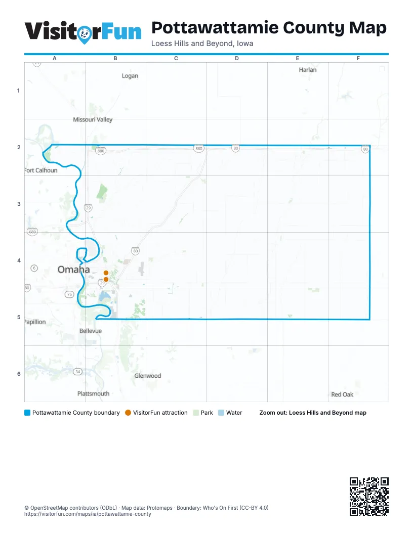
Maps inside Pottawattamie County
2 maps inside, from the street map of Pottawattamie County down.
City
Town
Street index of Pottawattamie County
Each street on the sheet and the grid squares it crosses.
- State Highway 92B4, C4, D4, E4, F4, B5
- Mahogany RoadB3, C3, D3, E3, F3
- US Highway 6B4, C4, D4, E4
- State Highway 83C2, D2, E2, F2
- East Kanesville BoulevardB4
- West Veterans Memorial HighwayA5, B5
- West BroadwayA4, B4
- South ExpresswayB4, B5
- US Highway 59E4
- Antique City DriveF2
- North 16th StreetB4
- 505th StreetF2, F3
- Abbott DriveA4
- Veterans Memorial HighwayA5
- South 7th StreetB4
- East Veterans Memorial HighwayB5
- Pearl StreetC2, F2, B4
- South 6th StreetB4
- Avoca LaneE2
- Highway StreetC3, E4
- West Kanesville BoulevardB4
- West Main StreetC4
- North 7th StreetA4, B4
- East High StreetE2
- East BroadwayB4
- North Walnut StreetE2
- North 6th StreetA4, B4
- South Chestnut StreetE2
- West High StreetE2
- South Walnut StreetE2
- Kimball StreetE3
- East Main StreetC4
- Tucson RoadF4
- Marne RoadF2
- Pioneer TrailB5, C5, D5, E5, F5
- Magnolia RoadB3, C3, D3, E3, F3
- Idlewood RoadB3, C3, B4, C4, D4, E4, F4
- Sumac RoadB3, C3, D3, E3, F3
- Pinoak RoadB3, C3, D3, E3, F3
- Whippoorwill RoadB2, C2, D2, E2, F2
- Sycamore RoadC2, D2, E2, F2, C3
- 290th StreetC2, C3, C4, C5
- 340th StreetD2, D3, D4, D5
- 510th StreetF2, F3, F4, F5
- 500th StreetF2, F3, F4, F5
- Chestnut RoadB5, C5, D5, E5, F5
- Railroad HighwayC2, C3, B4
- York RoadB2, C2, D2, E2, F2
- 380th StreetD2, D3, D4, D5
- 400th StreetE2, E3, D4, E4, E5
- 330th StreetD2, D3, D4, D5
- Old Lincoln HighwayB2, B3, B4
- 310th StreetC2, C3, C4, C5
- 270th StreetC2, C3, C4, C5
- Westgate RoadA2, B2, C2, D2, F2
- 300th StreetC2, C3, C4, C5
- 250th StreetC2, C3, C4, C5
- Tamarack AvenueC2, D2, E2
- McPherson AvenueB4, C4
- Coldwater AvenueB2, B3
- Wabash AvenueB5
- County Highway L34B2, C2, C3
- 298th StreetC2, C3, C4
- Eastern Hills DriveB4
- 23rd AvenueB4
- Valley View DriveB4, E4, B5
- 265th StreetC3, C4
- South 35th StreetB4, B5
- Avenue GA4, B4
- Harry Langdon BoulevardB4, B5
- 5th AvenueA4, B4
- South 24th StreetB4, B5
- 9th AvenueB4
- North BroadwayB4
- College RoadB4
- Madison AvenueB4
- North StreetF2, C3, E4
- North 8th StreetA4, B4
- 335th StreetD2
- Main StreetD2, C4, D5, E5
- Old Mormon Bridge RoadB3
- South 8th StreetB4
- South 16th StreetB4
- County Highway L52C4
- East Locust StreetA4, B4
- Harrison StreetB4, E4
- Bennett AvenueB4
- East Pierce StreetB4
- 5th StreetC2, D2, C3, C4
- South Main StreetE3, B4, E4
- Highway 83E2
- South 3rd StreetB4
- Woodbury AvenueB4
- Nebraska AvenueB4
- Bunge AvenueB5
- Lincoln StreetD2
- North Main StreetE3, B4, E4
- Bluff StreetB4, E4
- Morman Bridge RoadB3
- Front StreetC2
- South 1st StreetB4
- North Eyberg AvenueC4
- Willow AvenueB4
- North 1st StreetB4
- South 2nd StreetC2
- West Pierce StreetB4
- North AvenueB4
- 10th StreetE5
- Highland RoadF3
- 221st StreetB5
- Overton AvenueB2
- Juniper RoadE2, B3, C3, D3, E3, F3
- Cottonwood RoadB4, C4, D4, E4, F4
- 490th StreetF2, F3, F4, F5
- 470th StreetE2, E3, E4, E5
- Rosewood RoadA3, B3, C3, D3, E3, F3
- 450th StreetE2, E3, E4, E5
- 370th StreetD2, D3, D4, D5
- 320th StreetD2, D3, D4, D5
- Honeysuckle RoadB4, C4, D4, E4
- 240th StreetC2, C3, C4, C5
- 145th StreetA2, B2, A3, B3
- 530th StreetF2, F3, F4
- 185th StreetB2, B3, B4
- 152nd StreetB2, B3
- 425th StreetE3, E4, E5
- Greenview RoadB4, C4
- Desoto AvenueA2, B2
- 385th StreetD2, D4, D5
- 190th StreetB2, B3
- 210th StreetB2, B3
- Joslin AvenueB3, B4
- 220th StreetB2, B3, B4, B5
- 520th StreetF2, F4, F5
- Applewood AvenueB5, C5
- 205th StreetB3, B4
- 170th StreetB2, B3
- 195th StreetB3
- Hunt AvenueB4, C4
- Mudhollow RoadB3, B4
- 192nd StreetB5
- Gifford RoadB5
- 140th StreetA2, A3
- 215th StreetB3
- Badger AvenueB3
- 2nd AvenueC3, A4, B4, B5
- Avenue BA4, B4
- Cougar AvenueB3
- 295th StreetC3
- Missouri AvenueB3
- Franklin AvenueB4
- Avenue AA4, B4
- 245th StreetC4
- South 11th StreetB4, B5
- 253rd StreetC5
- 535th StreetF4, F5
- State Orchard RoadB4
- Monument RoadB4
- 3rd StreetC2, D2, C3, C4
- Terrace AvenueB2
- South Shore DriveB5
- 34th AvenueB4
- Grand AvenueB4
- East Manawa DriveB5
- North 9th StreetA4, B4
- Indian Hills RoadB4
- Mynster Springs RoadB4
- Three Bridge RoadB4, C4
- Concord LoopB4
- North 13th StreetA4, B4
- McClelland AvenueC4
- Longview DriveB4
- 16th AvenueB4
- 235th StreetC4
- Avenue LB4
- West Shore DriveB5
- 2nd StreetC2, D2, C3, C4
- South 19th StreetB4, B5
- Sunnydale RoadB4
- Oakland AvenueB4, E4
- High StreetC2, B4, E4
- 32nd AvenueB4
- Twin City DriveB4, B5
- South 21st StreetB4, B5
- Steven RoadB4
- Simms AvenueB4
- Avenue QA4, B4
- River RoadA4, B4
- North 25th StreetB4
- 35th AvenueB4
- Southbound Frontage RoadA4, B4
- 110th StreetA2
- Cedar LaneB4
- Northbound Frontage RoadA4, B4
- Truman AvenueF2
- South 55th AvenueB5
- Whippoorwill Road (G 16)F2
- Nash BoulevardB4
- South 32nd StreetB4
- North 21st StreetB4
- Lincoln AvenueB4
- North 28th StreetB4
- Big Lake RoadB4
- Graham Avenue WestB4
- Gleason AvenueB4
- Cathy LaneB4
- Metro DriveB4, B5
- Redick BoulevardA4
- McKenzie AvenueB4
- North 32nd StreetB4
- East South Omaha Bridge RoadB5
- South 4th StreetB4
- 19th AvenueB4
- Bonham StreetB4
- North 35th StreetB4
- Navaho StreetB5
- South 25th StreetB4
- South 28th StreetB4
- Spencer AvenueB4
- Railroad AvenueC4
- East Welch StreetB3
- Willow DriveA4
- C AvenueE5
- North 40th StreetA4
- North Commercial StreetE4
- Mall DriveB4
- Bent Tree RidgeC4
- West Washington AvenueB4
- Graham Avenue EastB4
- West Graham AvenueB4
- Marshal AvenueB4
- South Commercial StreetE4
- Umbrella RoadF2
- Oak RoadE2
- County Highway G 6LC4
- Page LaneB3
- Morgan StreetB4
- 40th StreetA4
- Commercial StreetB4, E4
- Yankton RoadF5
- Dogwood RoadB4, C4, D4, E4, F4
- Elmtree RoadC4, D4, E4, F4
- Teakwood RoadB2, C2, D2, E2, F2
- 350th StreetD2, D3, D4, D5
- 440th StreetE3, E4, E5
- Hickory RoadC4, D4, E4, F4
- 390th StreetD2, D3, D4, D5
- Aspen RoadC5, D5, E5
- Beechnut RoadC5, D5, E5, F5
- Lombardy RoadB3, C3, D3, E3, F3
- 460th StreetE2, E3, E4, E5
- 430th StreetE2, E3, E4, E5
- 525th StreetF3, F4, F5
- Hackberry RoadB4, C4, E4, F4
- 410th StreetE2, E3, E4
- Applewood RoadB5, C5, D5, E5
- 420th StreetE2, E3, E4, E5
- 260th StreetC2, C3, C4, C5
- 480th StreetE2, E3, E4, E5
- 360th StreetD2, D3, D4, D5
- 230th StreetC3, C4, C5
- Basswood RoadB5, C5, E5, F5
- 515th StreetF2, F3, F4
- 280th StreetC2, C3, C4, C5
- River Road NorthA3, B3, B4
- 275th StreetC4, C5
- 432nd StreetE5
- 175th StreetB2
- 225th StreetB4, C4
- 130th StreetA2, A3
- Lime Kiln RoadB3, B4
- Sandy LoopA2, A3
- Woodland TrailB5, C5
- 3rd AvenueC3, A4, B4, B5
- Ski Hill LoopB3
- Leisure AvenueB3
- Avenue DA4, B4
- 100 StreetE5
- Hemlock AvenueE4
- 8th AvenueA4, B4
- Avenue CA4, B4
- 7th AvenueA4, B4
- 4th AvenueC3, A4, B4
- 14th AvenueB4
- 6th AvenueB4
- Perry RoadB4
- Overland TrailB4, B5
- Avenue EA4, B4
- 345th StreetD2, D4
- Avenue HA4, B4
- Avenue FA4, B4
- Jefferson AvenueB3
- Meadowlark LoopA3, B3
- 272nd StreetC3, C4
- County Road M-21D5
- 208th StreetB2, B3
- Contrail AvenueF4
- 238th StreetC4
- Shadow AvenueB2, B3
- South 9th StreetB4, B5
Things to do on the Pottawattamie County map
Places on the map
- Arrowhead County Park
- Avoca
- Belknap Township
- Bent Tree Golf Club
- Big Lake Park
- Boomer Township
- Botna Bend County Park
- Carson
- Carson Township
- Carter Lake
- Center Township
- Council Bluffs
- Council Bluffs Country Club
- Council Bluffs Municipal Airport
- Council Bluffs Yard
- Crescent
- Crescent Township
- Dodge Riverside Golf Club
- Fairmount Park
- Fox Run Golf Club
- Garner Township
- Gibson Bend
- Google Data Center
- Grove Township
- Hancock
- Hardin Township
- Harveys Recreation Complex
- Hazel Dell Township
- Hitchcock Nature Center
- James Township
- Kane Township
- Keg Creek Township
- Knox Township
- Lake Manawa
- Lake Manawa Power Centre
- Lake Manawa State Park
- Lake Township
- Layton Township
- Lewis and Clark Monument Park
- Lewis Township
Next to Pottawattamie County
- Bellevue
- Fort Calhoun
- Glenwood
- Harlan
- La Vista
- Logan
- Missouri Valley
- Omaha
- Papillion
- Plattsmouth
- Red Oak
© OpenStreetMap contributors, Open Database License, openstreetmap.org/copyright · Map data: Protomaps · Boundary: Who's On First (CC-BY 4.0); Quattroshapes (CC BY 2.0)















