

Iowa map
Iowa County map
About 16,423 people live here (Census Bureau, 2024 estimate). The sheet's index lists 300 streets; 310th Street, R Avenue and W Avenue cross the most grid squares. Things to do inside the boundary: Amana Colonies.
Open the map (PDF, US Letter)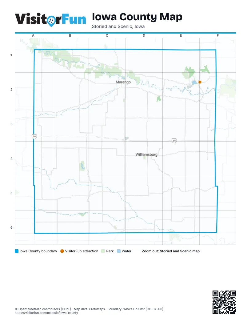
Maps inside Iowa County
1 map inside, from the street map of Iowa County down.
Street index of Iowa County
Each street on the sheet and the grid squares it crosses.
- B AvenueA1, A2, A3, A4, A5, A6
- M AvenueC1, C2, C3, C4, C5, C6
- U AvenueE1, E2, E3, E4, E5, E6
- W AvenueF1, E2, F2, F3, F4, E5, F5
- P AvenueD1, D2, D3, D4, D5, D6
- 212th BoulevardA1, B1, B2, C2
- 220th TrailE2, F2
- 290th StreetB5, C5, D5, F5
- West AvenueE2, F2
- State Highway 21A1
- State Highway 149D4, C6
- South Highland StreetD4, C6
- Cleveland StreetB2, D5
- Western AvenueC2
- West South StreetC2, D4
- Pacific StreetB2
- Hatter AvenueD5
- Grand Army of the Republic HighwayB3
- County Highway F52A5, B5, C5, D5, E5, F5
- 210th StreetA3, B3, C3, D3, E3, F3
- H AvenueB2, B3, B4, B5, C5, C6
- L AvenueC1, C2, C3, C4, C5, C6
- 190th StreetA3, B3, C3, D3, E3, F3
- 240th StreetA4, B4, C4, D4, E4, F4
- F AvenueB1, B2, B3, B4, B5, B6
- D AvenueB1, B2, B3, B4, B5, B6
- Poweshiek-Iowa RoadA1, A2, A3, A4, A5, A6
- E AvenueB1, B2, B3, B4, B5, B6
- V AvenueE1, E2, E3, E4, E5, E6
- 325th StreetA6, B6, C6, D6, E6
- 230th StreetA4, B4, C4, D4, E4
- 110th StreetA1, D1, E1, F1
- G AvenueB2, B3, B5, B6
- County Highway F15C1, D1, D2, E2
- Benton Iowa RoadB1, C1, D1, E1, F1
- 108th StreetB1, C1
- A DiagonalA3, B3
- A AvenueA1, A2, A3
- 245th StreetD4, E4, F4
- 335th StreetC6, D6, E6, F6
- Johnson Iowa Road SouthwestF5, F6
- Q BoulevardD4, E4, E5
- 125th StreetA1, B1
- Gg AvenueB5, C5, B6
- Eastern AvenueC1, C2
- 145th StreetA2
- Ss AvenueE2, E5
- County Highway F67C6, D6, E6
- Washington StreetA3, D4, B5
- D StreetE2, F2, D3
- West Washington StreetC2, C6
- Maplewood AvenueD4
- East Washington StreetC2, D2, C6
- Oak StreetD4
- West Welsh StreetD4
- East State StreetD4
- County Line RoadA3
- 3rd StreetA3
- North HighlandD3
- Grant StreetB2
- East StreetB2, C6
- Ballard StreetB5, C5
- Amana Road NorthwestF2
- Dogwood AvenueE6
- Welsh StreetD4
- State Highway 419A3
- 120th Street NorthwestF1
- 190th AvenueB6
- Fillmore StreetC5
- 21st AvenueC1
- Black Diamond Road SouthwestF5
- County Highway V52B2
- IWV Road SouthwestF4
- J AvenueC2, C3, C4, C5, C6
- S AvenueE1, E2, E3, E4, E5, E6
- R AvenueD1, E1, E2, E3, D4, E4, D5, E5, E6
- Y AvenueF1, F2, F3, F4, F5, F6
- 160th StreetA2, B2, C2, D2, F2
- 305th StreetB5, C5, D5, E5, F5
- 180th StreetA3, B3, C3, E3, F3
- 200th StreetB3, C3, D3, E3, F3
- Kk AvenueC1, C2, C3, C5, C6
- 216th StreetB3, C3, B4, B5
- 275th StreetB5, C5, E5, F5
- 320th StreetB6, C6, D6, E6, F6
- Hh AvenueC2, C3, C4
- Keokuk Iowa RoadA6, B6, C6, D6, E6
- WW AvenueF2, F3, F5, F6
- Pp AvenueD1, D2, D3, D4, D6
- 170th StreetA2, B2, C2, D2, E2
- CC AvenueB1, B2, A4, B4, B5
- 265th StreetA4, B4, C4, D4
- Jj AvenueC2, C3, C6
- Johnson Iowa Road NorthwestF1, F2
- 172nd StreetC2, D2
- 323rd StreetD6, E6
- 263rd StreetA4
- Dd AvenueB1, B5, B6
- Qq AvenueD4
- 168th StreetC2
- K StreetE2
- 540th Street SouthwestF6
- 27th AvenueE2
- 338th AvenueE6
- 232nd AvenueC6
- 160th AvenueA6
- 520th AvenueA6
- 310th StreetB5, C5, E5, F5, A6, B6, C6, D6, E6, F6
- T AvenueE1, E2, E3, E4, E5
- 300th StreetA5, B5, C5, D5, E5, F5
- Nn AvenueD1, D2, D3, D4, D5, D6
- C AvenueA1, A2, A3, A4, A5, A6
- 270th StreetA5, B5, C5, D5, E5
- Q AvenueD1, D2, D3, D4, D5, D6
- 220th StreetA3, B3, C3, D3, E3, F3, F4
- 280th StreetA5, B5, C5, D5, E5
- Mm AvenueD1, D2, D3, D4, D5, D6
- N AvenueD1, D2, D4, D5, D6
- 250th StreetA4, B4, C4, D4, E4
- K AvenueC3, C4, C5, C6
- 260th StreetB4, C4, E4, F4
- I AvenueC1, C2, C3, C4, C5, C6
- O AvenueD1, D2, D4, D5, D6
- 225th StreetC4, D4, E4, F4
- Johnson-Iowa RoadF1, F2, F3, F4
- 336th StreetB6, C6
- 120th StreetA1, E1, F1
- 330th StreetA6, C6, D6, F6
- 130th StreetA1, B1, C1, C2
- 169th StreetD2, E2
- 175th StreetC2, D2, E2, E3
- Ee AvenueB1, B3, B4
- 315th StreetB6, C6, D6, E6
- 140th StreetA2, B2
- 247th StreetC4
- TT AvenueE5, E6
- 148th StreetB2
- 297th StreetB5
- Iowa-Washington RoadE6, F6
- Bb AvenueA3, A4, A5
- RR AvenueE4
- 150th StreetB2, C2
- 294th StreetB5, C5
- 138th StreetC2
- 235th StreetC4, D4
- 333rd StreetE6
- 107th StreetC1, D1
- Keokuk IowaB6
- Cyclone DriveD4
- 266th StreetB4, B5, C5
- F StreetE2, F2, D3
- Main StreetB2, A3, B5, C5
- 155th StreetB2
- Oo AvenueD6
- Vv AvenueE1, E4
- V StreetE2, F2
- 295th StreetC5
- 338th StreetF6
- Ff AvenueB1, B2
- North StreetD4, C6
- Portwood DriveF2, F3
- 288th StreetA5, B5
- Court AvenueC2
- 152nd StreetB2
- 163rd StreetA2
- 255th StreetC4, D4
- Yy AvenueF5
- East South StreetC2, D2, D4
- Mud RoadB2
- 215th StreetF3
- C StreetE2, F2
- 38th AvenueE2
- Franklyn AvenueC2
- Y DriveF1, F2
- Industrial Park DriveD4
- East Main StreetC2, D2
- West State StreetB2, D4
- Ll AvenueC1
- 55th AvenueE6
- G StreetE2
- Lafayette AvenueC2
- 126th StreetB1, E1
- N DriveD5
- 141st StreetC2
- Elm StreetB2, D4
- 332nd StreetC6
- 165th StreetC2, D2
- Franklin StreetA3, D4
- County Highway W18E6
- Howard AvenueC2
- West Penn StreetD4
- Lincoln AvenueC2
- West Broad StreetC6
- Wallace AvenueD2
- East Marion StreetC2, D2
- Court StreetA3, D4
- Marengo AvenueC2
- Chatham StreetD4
- 116th StreetD1
- Clinton AvenueC2
- Short AvenueC2
- 123rd StreetF1
- 44th AvenueE2, F2
- 118th StreetE1
- East Hilton StreetC2, D2
- 4th AvenueE2, D3
- 8th AvenueD3
- West Miller StreetC2
- William AvenueC2
- Jefferson AvenueD2
- 7th AvenueE2, D3
- West Pine StreetC2
- Harrison StreetB2, A3
- H StreetE2, F2
- West Walnut StreetD4
- County Highway F35C3
- West StreetB2, D4, C6
- Cherry AvenueC2
- 286th StreetA5
- Long StreetD4
- West Maple StreetD4
- Hawkeye DriveD4
- 272nd StreetE5
- 273rd StreetB5
- Madison StreetD4
- West Main StreetC2
- West Randolph StreetC2
- West Adams StreetC2
- 5th StreetA3
- West Marion StreetC2
- West Hilton StreetC2
- 4th StreetA3
- 2nd StreetA3
- East Randolph StreetC2, D2
- East Adams StreetC2, D2
- 142nd StreetC2
- 121st StreetE1, F1
- Jackson StreetB5, C5
- South Walnut StreetD4, C6
- West Lucas StreetC2
- High StreetB2, D4
- 510th AvenueA6
- Clark StreetD4
- 284th StreetB5
- West Evans StreetD3
- West Oak StreetC6
- I StreetE2, F2
- 1st StreetA3
- Williams StreetA3
- Page StreetD4
- East Miller StreetC2, D2
- East Pine StreetC2, D2
- Clinton StreetA3
- Roger's DriveD4
- Garfield StreetB2, C2, B3
- Wilson StreetD4
- North Hampton DriveD4
- 25th AvenueD1, E2
- 48th AvenueF2
- Country Club RoadD4
- 39th AvenueE2
- South Main StreetC6
- Karen DriveD4
- East Clark StreetC6
- Kenton WayD4
- E StreetF2, D3
- Q StreetE2
- East Oak StreetC6
- 6th StreetA3
- Valley RoadD4
- Nn DriveD2
- 125th DriveD1
- Northridge DriveF1
- 29th AvenueE1, E2
- Raider DriveD4
- J StreetE2
- 46th AvenueF2
- East North StreetC2
- Southridge DriveF1
- Bedford RoadD4
- 176th StreetC3
- Short StreetB2, D4
- 31st AvenueE2
- Hendricks StreetD5
- Circle DriveD4
- Heritage DriveD5
- Tilden StreetD5
- Milwaukee AvenueD5
- Bailey Park RoadD4
- Boland AvenueD5
- Dillin StreetC2
- St Paul AvenueD5
- West Clark StreetC6
- 128th StreetB1
- Hampton CircleD4
- 49th AvenueF2
- 122nd StreetF1
- Alpine CourtD4
- Pine StreetB2
- 6th AvenueE2, D3
Things to do on the Iowa County map
Places on the map
- Amana Colonies Golf Course
- Amana Elementary School
- Amana RV Park & Event Center
- Berstier Woods
- Big Bend Conservation Area
- Dayton Township
- East Iowa Bible Camp
- English Township
- Fillmore Township
- Gateway Park
- Greene Township
- Gunderson Wildlife Area
- Hartford Township
- Highland Ridge
- Hilton Township
- Holdens Pond
- Honey Creek Township
- Iowa County Fairgrounds
- Iowa River Corridor Wildlife Management Area
- Iowa River Corridor WMA - Cottonwood Banks
- Iowa River Corridor WMA - Randolph Access
- Ladora
- Lake Iowa
- Lake Iowa Park
- Lenox Township
- Lilly Pond
- Lincoln Township
- Marengo
- Marengo Golf Club
- Marengo Township
- Millersburg
- North English
- Parnell
- Pilot Township
- Simmons Timber Reserve
- Troy Township
- Victor
- Washington Township
- Williamsburg
- York Township
© OpenStreetMap contributors, Open Database License, openstreetmap.org/copyright · Map data: Protomaps · Boundary: Who's On First (CC-BY 4.0); Quattroshapes (CC BY 2.0)