

Iowa map
Storied and Scenic map
The sheet's index lists 21 highways; US 61, IA 27 and US 30 cross the most grid squares. Things to do inside the boundary: Amana Colonies, American Gothic House and Figge Art Museum. Also on it: Albia, Anamosa and Belle Plaine.
Open the map (PDF, US Letter)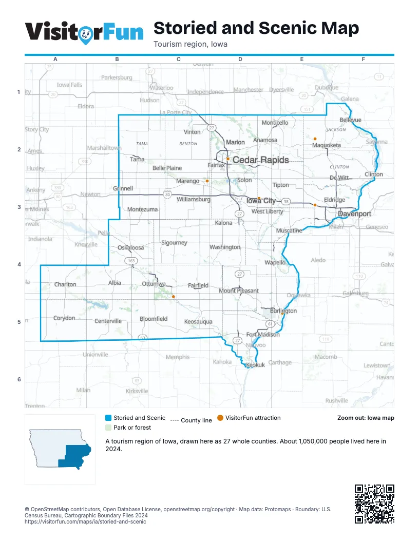
Highway index of Storied and Scenic
Each highway on the sheet and the grid squares it crosses.
- I-74F3
- I-80B3, C3, D3, E3, F3
- I-280E3
- I-380C1, C2, D2, D3
- US 6E3, F3
- US 30B2, C2, D2, E2, F2, F3
- US 34C4, D4, D5, E5
- US 61D5, D6, E1, E2, E3, E4, E5, F2, F3
- US 63B4, B5, C4, C5
- US 67F2, F3
- US 136D6
- US 151D2, E1, E2
- US 218C2, D2, D3, D4, D5, D6
- IA 2B5, C5
- IA 13D1, D2
- IA 22E3
- IA 27C1, C2, D2, D3, D4, D5, D6
- IA 92B4, E3, E4
- IA 100D2
- IA 149C4
- IA 163B3, B4, C4, D4, D5, E5
Things to do on the Storied and Scenic map
- Amana Colonies
- American Gothic House
- Figge Art Museum
- Greater Burlington
- Herbert Hoover National Historic Site
- Herbert Hoover Presidential Library and Museum
- Iowa 80 Truckstop
- Lacey-Keosauqua State Park
- Lake Darling State Park
- Lake Keomah State Park
- Maquoketa Caves State Park
- National Czech & Slovak Museum & Library
- Putnam Museum
- Red Haw State Park
- University of Iowa Stanley Museum of Art
- Vander Veer Botanical Park
- Wapsipinicon State Park
- Wildcat Den State Park
Places on the map
- Albia
- Anamosa
- Belle Plaine
- Bellevue
- Bloomfield
- Burlington
- Cedar Rapids
- Centerville
- Chariton
- Clinton
- Corydon
- Davenport
- De Witt
- Eldridge
- Fairfax
- Fairfield
- Fort Madison
- Grinnell
- Iowa City
- Kalona
- Keokuk
- Keosauqua
- Maquoketa
- Marengo
- Marion
- Montezuma
- Monticello
- Mount Pleasant
- Muscatine
- Oskaloosa
- Ottumwa
- Sigourney
- Solon
- Tama
- Tipton
- Vinton
- Wapello
- Washington
- West Liberty
- Williamsburg
Next to Storied and Scenic
- Capital Country map
- Driftless Area map
- Loess Hills and Beyond map
- Great Rivers Country
- Northeast Missouri
- Northwest Missouri
© OpenStreetMap contributors, Open Database License, openstreetmap.org/copyright · Map data: Protomaps · Boundary: U.S. Census Bureau, Cartographic Boundary Files 2024