

Iowa map
Jasper County map
About 38,107 people live here (Census Bureau, 2024 estimate). The sheet's index lists 105 streets; State Highway 14, State Highway 117 and County Highway T38 cross the most grid squares. Also on it: Agnes Patterson Memorial Park, Ashton Wildwood Park and Aurora Heights.
Open the map (PDF, US Letter)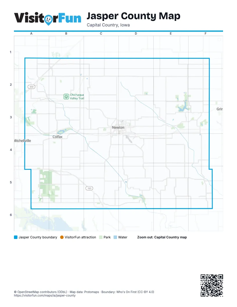
Maps inside Jasper County
1 map inside, from the street map of Jasper County down.
Street index of Jasper County
Each street on the sheet and the grid squares it crosses.
- County S62 NorthC1, C2
- Reed AvenueE1
- State Highway 14E1, C2, D2, E2, C3, C4, C5, C6
- County Highway T38F1, F2, F3, F5
- County Highway F17A2, B2
- Highway F24 WestA2, B2
- State Highway 117A2, B2, B3, B4, B5
- County Highway S52 NorthB2, B3
- Highway F17 WestB2, C2
- Buchanan StreetC2
- County F17C2
- County Highway F17 WestC2
- East Buchannan StreetC2
- Highway F 17 WestC2
- West Buchanan StreetC2
- Highway F17 EastE2, F2
- Highway F27 EastE2, E3, F3
- State Highway 224 EastE2
- State Highway 224 NorthE2, E3
- Highway T38 NorthF2, F3
- Newburg RoadF2
- County Highway S52 SouthB3
- Highway F36 WestB3, C3
- North State Highway 117B3, B4
- Old Hwy 6B3, C3, B4
- 1st Avenue EastC3, D3
- 1st Avenue WestC3
- 1st Street NorthC3
- County Highway F48C3
- North 19th Avenue EastC3, D3
- North 19th Avenue WestC3
- North 23rd Avenue WestC3
- South 12th Avenue WestC3
- South 8th Avenue EastC3, D3
- South 8th Avenue WestC3
- Union DriveC3
- West 12th Street SouthC3
- West 4th Street NorthC3
- West 8th Street NorthC3
- East 12th Street NorthD3
- East 12th Street SouthD3, D4
- East 19th Street NorthD3
- Grand Army of the Republic HighwayD3
- Iowa Speedway DriveD3, D4
- North 8th Avenue EastD3
- Northeast Belt Line RoadD3
- South 13th Avenue EastD3
- East StreetE3, F5
- State Highway 224 SouthE3, E4
- 375th AvenueF3
- East 149th Street SouthF3
- Highway F 27F3
- Highway F 27 EastF3
- Highway T 38F3
- Highway T 38 NorthF3
- Highway T38 SouthF3, F4, F5, F6
- Highway F48 WestA4, B4
- County Highway F48 WestB4
- East State StreetB4
- North Walnut StreetB4
- South League RoadB4
- South Walnut StreetB4
- West State StreetB4
- State Highway 14 SouthC4, C5
- County Highway S 74 SD4, D5
- County Highway S74 SouthD4
- East 64th Street SouthD4, D5
- East 68th Street SouthD4
- Legion StreetD4
- Liberty AvenueD4
- Lincoln StreetD4
- South 28th Avenue EastD4
- County Highway T22E4
- Highway T22 SouthE4, E5
- Northwest 12th AvenueA5
- West 116th Street SouthA5, B5
- County Highway S6 GB5, B6
- East 2nd StreetB5
- Highway F62 WestB5, C5
- North State StreetB5
- South State StreetB5
- State Highway 163 (Bus)B5, C5, C6
- West 109th Street SouthB5
- West 2nd StreetB5
- County Highway F62C5
- Highway F62 EastC5, D5, E5
- State Highway 163C5, C6
- Broad StreetD5
- East 72nd Street SouthD5
- Highway T14 SouthD5, E5, E6
- Main StreetD5
- North StreetD5
- 1st StreetE5, F5
- Highway T33 SouthE5, F5, F6
- 4th StreetF5
- County Road F62F5
- River StreetF5
- Highway F70 WestA6, B6, C6
- Jasper StreetC6
- Monroe StreetC6
- North Monroe StreetC6
- Sherman StreetC6
- South Monroe StreetC6
- West Washington StreetC6
- County Highway T33F6
Places on the map
- Agnes Patterson Memorial Park
- Ashton Wildwood Park
- Aurora Heights
- Bailey Wildlife Area
- Baxter
- Bittersweet Estates
- Bradford Estates
- Buena Vista Township
- Carrier's Meadows
- Chichaqua Valley Trail
- Chichaqua Wildlife Management Area
- Clarks Lake
- Clear Creek Township
- Clear Creek Wildlife Area
- Colfax
- Colfax Golf Club
- Conard Environmental Research Area
- Country Club Acres
- Dam Prairie
- Denniston Knolls
- Des Moines Township
- Diamond Trail Golf Club
- Eastgate Place
- Elk Creek Township
- Elm Park
- Elm Park Place
- Ennis Estates
- Fairmeadows
- Fairmeadows North
- Fairview Township
- Fountain Hills Estate
- Gateway Recreation Golf Course
- Golf View Estates
- Hickory Grove Township
- Hidden Oaks
- Hoffman Wildlife Area
- Independence Township
- Indian Creek
- Iowa Speedway
- Jacob Krumm Nature Preserve
Next to Jasper County
- Grinnell
- Mitchellville
© OpenStreetMap contributors (ODbL) · Map data: Protomaps · Boundary: Who's On First (CC-BY 4.0)