

Iowa road map
Lincoln Highway Heritage Byway map
The Lincoln Highway Heritage Byway has been a National Scenic Byway since 2021, named for its historic qualities: about 450 miles in Iowa. It meets 37 highways, among them I-29, I-35 and I-380. Towns along it: Cedar Rapids, Ames and Council Bluffs.
Open the map (PDF, US Letter)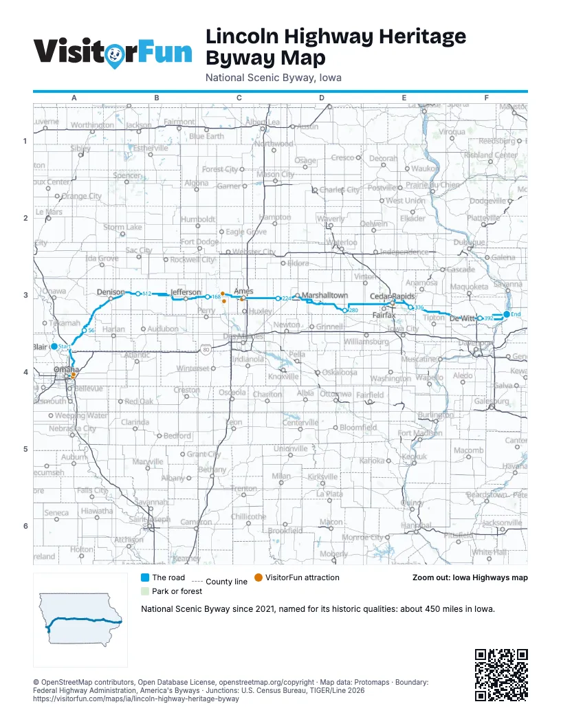
Highways it meets
Each highway it meets and the grid squares where they meet.
- US 30A4
- I-29A4
- I-480A4
- US 6A4
- I-880A4
- IA 183A4
- IA 127A4
- IA 44A3
- IA 37A3
- US 59A3
- US 71B3
- IA 25B3
- IA 4B3
- IA 144B3
- US 169C3
- IA 17C3
- US 69C3
- I-35C3
- US 65C3
- IA 330D3
- IA 14D3
- IA 146D3
- US 63D3
- IA 21D3
- IA 131D3
- IA 200D3
- US 218E3
- I-380E3
- IA 94E3
- US 151E3
- IA 13E3
- IA 1E3
- IA 38E3
- US 61F3
- US 67F3
- IA 136F3
- IA 100E3
Towns along the Lincoln Highway Heritage Byway
In mile order, with the grid square of each.
- California Junctionmile 5, A4
- Missouri Valleymile 10, A4
- Council Bluffsmile 11, A4
- Carter Lakemile 11, A4
- Crescentmile 23, A4
- Lovelandmile 35, A4
- Loganmile 48, A4
- Woodbinemile 58, A3
- Dunlapmile 69, A3
- Arionmile 81, A3
- Denisonmile 87, A3
- Vailmile 99, B3
- Westsidemile 105, B3
- Arcadiamile 109, B3
- Carrollmile 118, B3
- Gliddenmile 128, B3
- Ralstonmile 133, B3
- Scrantonmile 140, B3
- Jeffersonmile 148, B3
- Grand Junctionmile 159, B3
- Beavermile 165, C3
- Ogdenmile 171, C3
- Boonemile 179, C3
- Amesmile 192, C3
- Nevadamile 203, C3
- Colomile 214, C3
- State Centermile 223, C3
- Marshalltownmile 236, D3
- Le Grandmile 248, D3
- Montourmile 252, D3
- Toledomile 260, D3
- Tamamile 260, D3
- Chelseamile 273, D3
- Belle Plainemile 280, D3
- Cedar Rapidsmile 315, E3
- Bertrammile 328, E3
- Mount Vernonmile 336, E3
- Lisbonmile 338, E3
- Mechanicsvillemile 346, E3
- Stanwoodmile 353, E3
- Clarencemile 358, E3
- Lowdenmile 366, F3
- Wheatlandmile 372, F3
- Calamusmile 377, F3
- Grand Moundmile 383, F3
- DeWittmile 388, F3
- Low Moormile 402, F3
- Clintonmile 402, F3
- Camanchemile 405, F3
- Marionmile 428, E3
Things to do on the Lincoln Highway Heritage Byway map
© OpenStreetMap contributors, Open Database License, openstreetmap.org/copyright · Map data: Protomaps · Boundary: Federal Highway Administration, America's Byways · Junctions: U.S. Census Bureau, TIGER/Line 2026















