

Iowa road map
Iowa highway map
9 Interstate routes run about 796 miles in Iowa, each on a sheet of its own. The sheet's index lists 32 highways; I-80, US 6 and US 20 cross the most grid squares. Towns on it: Des Moines, Cedar Rapids and Davenport.
Open the map (PDF, US Letter)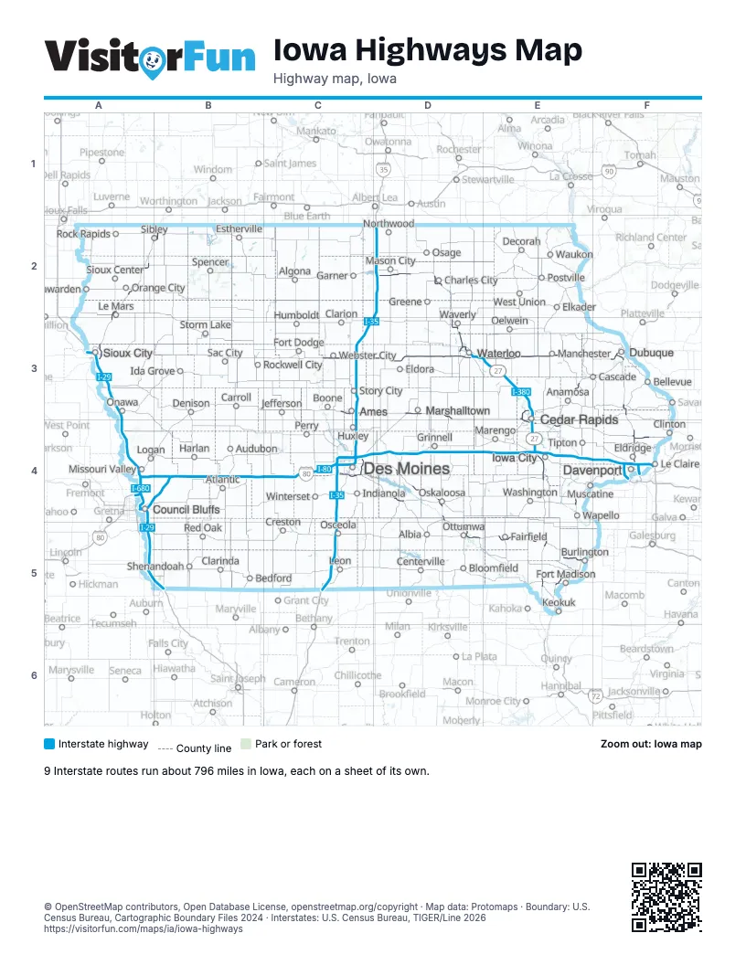
Road maps of Iowa
9 road maps: each Interstate and byway on a sheet of its own.
Highway index of Iowa
Each highway on the sheet and the grid squares it crosses.
- I-29A3, A4, A5, B5
- I-35C3, C4, C5, D2
- I-74F4
- I-80A4, B4, C4, D4, E4, F4
- I-129A3
- I-235C4
- I-280F4
- I-380D3, E3, E4
- I-480A4
- I-680A4
- I-880A4, B4
- US 6A4, B4, C4, D4, E4, F4
- US 18D2
- US 20A3, C3, D3, E3, F3
- US 30C3, D3, E3, E4, F4
- US 34D5, E5
- US 52E3, F3
- US 61E4, E5, F3, F4
- US 63D2, D4, D5
- US 65C4
- US 75A2, A3
- US 151E3, E4, F3
- US 218D2, D3, E3, E4, E5
- US 275A4, A5
- IA 5C4, D4
- IA 27D2, D3, E3, E4, E5
- IA 57D3
- IA 58D3
- IA 60A2, B2
- IA 92D4, E4
- IA 100E3
- IA 163D4, D5, E5
Places on the map
- Albia
- Algona
- Ames
- Anamosa
- Atlantic
- Audubon
- Bedford
- Bellevue
- Bloomfield
- Boone
- Burlington
- Carroll
- Cascade
- Cedar Rapids
- Centerville
- Charles City
- Clarinda
- Clarion
- Clinton
- Council Bluffs
- Creston
- Davenport
- Decorah
- Denison
- Des Moines
- Dubuque
- Eldora
- Eldridge
- Elkader
- Estherville
- Fairfield
- Fort Dodge
- Fort Madison
- Garner
- Greene
- Grinnell
- Harlan
- Hawarden
- Humboldt
- Huxley
- Ida Grove
- Indianola
- Iowa City
- Jefferson
- Keokuk
- Le Claire
- Le Mars
- Leon
- Logan
- Manchester
- Marengo
- Marshalltown
- Mason City
- Missouri Valley
- Muscatine
- Northwood
- Oelwein
- Onawa
- Orange City
- Osage
- Osceola
- Oskaloosa
- Ottumwa
- Perry
- Postville
- Red Oak
- Rock Rapids
- Rockwell City
- Sac City
- Shenandoah
- Sibley
- Sioux Center
- Sioux City
- Spencer
- Storm Lake
- Story City
- Tipton
- Wapello
- Washington
- Waterloo
- Waukon
- Waverly
- Webster City
- West Union
- Winterset
© OpenStreetMap contributors, Open Database License, openstreetmap.org/copyright · Map data: Protomaps · Boundary: U.S. Census Bureau, Cartographic Boundary Files 2024 · Interstates: U.S. Census Bureau, TIGER/Line 2026















