

Iowa map
Madison County map
About 17,161 people live here (Census Bureau, 2024 estimate). The sheet's index lists 300 streets; 130th Street, 265th Street and Cottonwood Avenue cross the most grid squares. Things to do inside the boundary: John Wayne Birthplace & Museum and Roseman Covered Bridge.
Open the map (PDF, US Letter)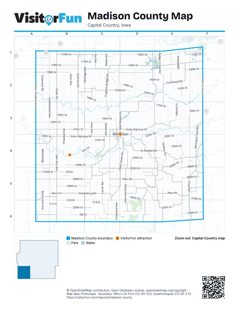
Street index of Madison County
Each street on the sheet and the grid squares it crosses.
- State Highway 92D3, E3, A4, B4, C4
- 210th StreetA3, B3, C3, D3
- North John Wayne DriveD3, D4
- County Road G6RE3
- County Road G14B1, C1, D1
- North 24th AvenueC3, C4
- North AvenueD1
- 120th StreetA1, B1, C1, D1, E1
- 105th StreetB1, C1, D1, E1, F1
- Cumming RoadE1, F1, D2, E2, D3
- 130th StreetF1, A2, B2, C2, D2, E2, F2
- Adair-Madison AvenueA1, A2, A3, A4, A5
- Pitzer RoadB1, B2, B3, B4
- Peru RoadC5, D5, E5, F5
- Valleyview AvenueE2, E4, E5, E6
- St Charles RoadD4, E4, F4
- Earlham RoadB1, B2, B3, B4
- Deer Run AvenueB4, B5, B6
- Clark Tower RoadD4, C5, D5, C6
- Macksburg RoadA5, B5, C5
- 330th StreetC6, D6, E6, F6
- Settlers AvenueE2, E3, E5, E6
- 320th StreetB6, C6, E6
- Wildrose AvenueE3, E5, E6, F6
- Badger Creek RoadE1, E2
- Rustic AvenueE4, E5, E6
- Truro RoadF4, E5, F5
- Bevington Park RoadF3, F4
- Pleasant View TrailD5, D6, E6
- Timber Ridge AvenueE1, E2, E6
- Veterans ParkwayE1, F1
- East North StreetD3, B5, E5
- Madison-Clarke StreetE6
- West North StreetC3, D3, B5, E5
- East StreetB5, B6
- County Road G61A5, B5, A6
- West Summit StreetC4, D4
- Morgan StreetE5, F5
- 318th StreetE6
- West Emerson StreetD5
- Grand Prairie ParkwayE1
- Earlhan RoadB3
- West Main StreetF4
- North West StreetE5
- North Morgan StreetF4
- Saint Charles RoadF4
- North Chestnut AvenueB1
- Deer RunB6
- South Morgan StreetF4
- Northwest 6th StreetB1
- South West StreetB5, E5
- East Main StreetF4
- East Emerson StreetD5, E5
- Tabor RoadE1
- C PlaceA1
- Northwest Walnut AvenueB1
- County Road P57B1, B3
- South John Wayne DriveD4
- Southwest Walnut AvenueB1
- County Highway P48A1
- Highway G50F4
- Cumming AvenueF1
- County Road R21E6
- Shore StreetE6
- Owl AvenueB6
- 260th StreetA4, B4, C4, D4, E4, F4
- Carver RoadC4, C5, C6
- 265th StreetE4, F4, A5, B5, C5, D5, E5
- Heritage AvenueB1, C1, C2, C3, C5, C6
- 290th StreetB5, C5, D5
- 280th StreetA5, B5, C5, E5, F5
- Millstream AvenueD4, D5, D6
- Settlers TrailE4, E5
- Warren AvenueF1, F2, F3, F4, F5, F6
- 200th StreetA3, B3, C3
- 270th StreetA5, B5, C5, D5
- Hogback Bridge RoadC1, C2, C3
- 152nd StreetC2, D2
- Quail Ridge AvenueD1, D3, E3, D4, E4, D5
- 330 StreetA6, B6, C6, D6, E6, F6
- Hiatt Apple RoadD4, E4, D5, E5
- Quail Ridge RoadD1, D2, E2, D5
- Clanton Creek RoadD5, D6
- Pammel Park RoadC4
- Norwood AvenueD3, D4, D5
- Woodland AvenueF1, F5
- 110th StreetA1, B1, D1, F1
- 300th StreetA5, D5, E5, F5
- Ivy AvenueC1, C6
- Homestead AvenueC4, C5
- Holliwell Bridge RoadD4
- Iowa AvenueC2, C3, C4
- Walnut TrailF4
- 275th StreetB5, C5, F5
- 158th StreetB2, C2
- Applewood AvenueA5, A6
- Pheasant Run TrailD5, D6
- North 8th AvenueC3, C4
- East Court AvenueD3, D4
- Oakcrest AvenueD5
- 330th LaneC6, D6
- South 4th AvenueC4
- Pleasant Run TrailD6
- County Road G53B5
- Brown StreetD5
- West Court AvenueC3, C4, D4
- 268th StreetE5
- North 16th AvenueC3, C4
- Northeast 6th StreetB1
- South 8th AvenueC4
- Husky DriveC4
- Northwest 97th StreetF2
- North Cross StreetF4
- 10th PlaceF4
- Quincy StreetF5
- South 16th AvenueC4
- Madison-Union StreetA6
- Seneca AvenueD1
- Southwest 60th StreetF1
- Rustic RoadE5
- 132nd AvenueD6
- Warren StreetF3
- North Warren AvenueF3
- South Odell AvenueD5
- Hoover StreetF3
- Elmwood AvenueB1, B2, B3, B4, B5, B6
- Fawn AvenueB1, B2, B3, B4, B5, B6
- Cottonwood AvenueB1, B2, B3, B4, B5, A6, B6
- 190th StreetA3, B3, C3, E3, F3
- Creamery RoadA1, A2, A3, B6
- Carriage TrailB4, B5
- 220th StreetA4, B4, E4, F4
- 235th StreetB4, D4, E4
- Bittersweet AvenueA4, A5, A6
- Terrace AvenueE3, E4, E5, E6
- Upland TrailE2, F2, E3
- Limestone AvenueC3, C5, C6
- 160th StreetA2, B2, D2, E2
- 115th StreetB1, C1, E1
- 140th StreetA2, D2, E2, F2
- North River TrailD2, D3
- 155th StreetE2, F2
- Fox TrailB4, C4
- 305th StreetC5, D5, E5
- 170th StreetA2, B2, B3, C3
- 310th StreetE5, F5, B6, C6, D6
- Kiowa AvenueC1, C3, C4, C5
- 150th StreetA2, B2
- 195th StreetB3, C3, D3
- Valleyview TrailE3, F3, E4
- Prairieview AvenueD1, D2
- 180th StreetA3, B3
- Harmon AvenueC2, C3, C4
- Ironwood TrailC2, C3
- Quarry TrailD3
- Roseman Bridge RoadB4
- 225th StreetB4, C4, D4
- 168th StreetB2, C2
- Ivy TrailC5, C6
- 135th StreetB2, C2
- 310 StreetB6, C6
- Upland AvenueE1, E2, E4
- BittersweetA4, A5
- Summerhill DriveE3
- Fieldstone AvenueB1, B2, B3, B4, B5, B6
- McBride RoadD2
- Juniper TrailC1, C2
- 230th StreetA4, B4, E4, F4
- Old Portland RoadD1, D2
- 225th TrailD3, E3, D4
- Elder Berry AvenueB4, B5
- Oriole AvenueD4, D5, D6
- Larkspur AvenueC6
- 315 StreetA6, B6
- Nature TrailD3
- 250th StreetD4
- Wind Wood TrailF2, F3
- Roseman Bridge TrailB4, C4
- 295th StreetC5, E5
- Quail Ridge TrailD2, D3, E3
- Pioneer AvenueD4, D5
- 170th DriveD2
- Hickory Ridge RoadE4
- North River School RoadC2, C3, D3
- Francesca AvenueB4
- Woodland LaneF2, F5, E6, F6
- 270 StreetB5, C5
- 137th StreetC2
- Vintage LaneE3, E4
- Willow Bend TrailF4
- 175th StreetD3, E3
- 148th StreetD2
- Cedar Bridge RoadD3
- Burr Oak AvenueA3, A4
- Old River TrailD2
- Knoll Ridge TrailC4
- 325th StreetA6, E6
- Green Valley TrailC3
- 195th TrailD3
- Mallard AvenueC5, D5, D6
- Settlers LaneE3
- Rustic DriveE6
- Quail Valley DriveE3
- 313 StreetC6
- ElmwoodB5
- Timber RidgeE4
- 282nd TrailE5
- Meadowview AvenueD1
- Prairie View RoadD1
- Hogback Bridge AvenueC3
- Prairie View AvenueD4, D5
- 214th DriveE3, E4
- Old Arrow LaneD5, D6
- 272nd LaneE5, F5
- Timber TrailE5
- 325 StreetA6, B6
- Green LaneB3
- 260th LaneC4, D4, E4
- Pammel Park TrailC4
- Old Portland AvenueD2
- South StreetB5, E5
- 178th LaneE3, F3
- 148th TrailC2, D2
- 185th StreetD3
- 340 StreetA6, B6, C6
- Woodbrook LaneF6
- 187th StreetE3
- Windwood AvenueF4
- Walnut LaneF2, F5, F6
- 165th StreetB2
- 220th AvenueF6
- Kimber Ridge AvenueE1, E2
- Union LaneE2, E4
- Iowa LaneC2
- Kiowa LaneC3
- 10th AvenueF3, F4
- Maple LaneD4, D5, D6
- 135th CourtE2, F2
- 280th TrailE5
- 133rd CourtE2
- Victory LaneE4
- Autumn AvenueA5
- 218th StreetF3
- 308th LaneD5, D6
- 145th LaneC2
- Cotton Wood AvenueB6
- Upland LaneE2, E4
- West Jefferson StreetC3, D3
- West Washington StreetC4, D4
- 255th StreetD4
- Heritage DriveC5
- 338 StreetB6
- 328th TrailB6
- 200th LaneF3
- 332nd StreetE6
- Fawn LaneB3
- 328 TrailB6
- Osage TrailD3
- Tree Line CourtE2
- Quail Ridge LaneE2, D3, E3
- Elderberry AvenueB2, B4
- Lime Stone AvenueC5
- West South StreetC4, D4
- Prairie StreetE5
- Norwood LaneD6
- North 10th StreetD3, D4
- North 4th AvenueC3, C4
- 230th LaneB4, D4
- 240th LaneC4, D4
- Cedar Bridge TrailD3
- 144th CourtE2, F2
- 132nd CourtD2
- 328th StreetE6
- 320th LaneD6
- Wind Wood LaneF3
- 315th LaneA6
- East Buchanan StreetD3
- 227th StreetC4
- West Mills StreetC3
- 200th TrailE3
- Timber LaneE4
- Quail Ridge DriveD6, E6
- 320 StreetC6
- Elmwood LaneB1
- Quiet LaneD4, D5
- North 8th StreetD3, D4
- Juniper AvenueC2, C3
- West Benton StreetC3, D3
- Juniper LaneC2
- Kippy LaneC4
- Holliwell Valley CourtD4
- East 1st StreetB1
- Lakeside LaneD3
- North 3rd AvenueC3, C4
- Imes Bridge RoadF4
- 255th LaneC4
- Knoll LaneC2
- 169th StreetB2
- Long StreetE3
- 278th LaneE5, F5
Things to do on the Madison County map
Places on the map
- Badger Creek State Recreation Area
- Bevington
- Bevington Post Office
- Cedar Bridge County Park
- Cedar Lake
- Clanton Creek Recreation Wildlife Area
- Crawford Township
- Douglas Township
- Earlham
- Earlham Cemetery
- Earlham City Hall
- East Peru
- Grand River Township
- Guye Woods
- Heritage Hills Wildlife Area
- Jackson Township
- Jefferson Township
- Lee Township
- Lincoln Township
- Macksburg
- Madison County Fairgrounds
- Madison Township
- Martin Marietta Sports Complex
- Microsoft datacenter
- Middle River Park
- Monroe Township
- Ohio Township
- Pammel State Park
- Patterson
- Penn Township
- Saint Charles
- Scott Township
- South Township
- Truro
- Union Township
- Walnut Township
- Webster Township
- Winterset
- Winterset City Park
- Winterset Municipal Airport
© OpenStreetMap contributors, Open Database License, openstreetmap.org/copyright · Map data: Protomaps · Boundary: Who's On First (CC-BY 4.0); Quattroshapes (CC BY 2.0)















