

Iowa map
Norwalk Township map
About 15,396 people live here (Census Bureau, 2024 estimate). The sheet's index lists 54 streets; Railroad Highway, Magnolia Road and Mahogany Road cross the most grid squares. Also on it: Underwood, Underwood High School and Underwood High School Track.
Open the map (PDF, US Letter)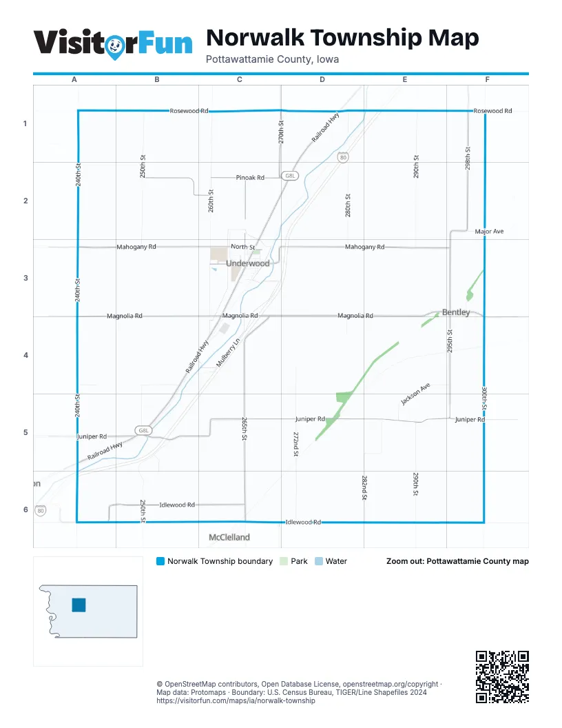
Street index of Norwalk Township
Each street on the sheet and the grid squares it crosses.
- 240th StreetA1, A2, A3, A4, A5
- Panama AvenueA1
- Rosewood RoadA1, B1, C1, D1, F1
- 250th StreetB1, B2, B3, B5, B6
- 260th StreetC1, C2, C3
- 270th StreetC1, D1, C2, D2, C6
- 280th StreetD1, D2, D3, D4
- Railroad HighwayD1, C2, D2, C3, B4, C4, A5, B5
- 290th StreetE1, E2, E3, E5, E6
- 298th StreetF1, F2
- Pinoak RoadB2, C2, D2
- 265th StreetC2, C3, C4, C5, C6
- Faith AvenueC2, C3
- 295th StreetF2, F3, F4, F5
- Major AvenueF2
- Magnolia RoadA3, B3, C3, D3, E3, F3, F4
- Mahogany RoadA3, B3, C3, D3, E3, F3
- 1st AvenueC3
- 1st StreetC3
- 2nd AvenueC3
- 2nd StreetC3, F3
- 3rd AvenueC3
- 3rd StreetC3
- 4th AvenueC3
- 4th StreetC3
- 5th StreetC3
- Charles DriveC3
- Clark CircleC3
- Eagle CircleC3
- Eagle LaneC3
- Hannah CircleC3
- High CircleC3
- Highway AvenueC3
- Highway StreetC3
- McKee RoadC3
- Milwaukee AvenueC3
- Mulberry LaneC3, C4
- North StreetC3
- Rain Circle RoadC3
- South StreetC3
- Sunset CircleC3
- Sunset DriveC3
- Bentey RoadF3
- Lombardy RoadA4
- Jaguar LoopB4, B5
- 272nd StreetD4, D5, D6
- Jackson AvenueE4, F4, E5
- 300th StreetF4, F5
- Juniper RoadA5, B5, C5, D5, E5, F5
- Jasmine LaneB5, B6
- Jasper LaneD5
- 282nd StreetE5, E6
- 238th StreetA6
- Idlewood RoadA6, B6, C6, D6
Places on the map
- Castor Cemetery
- Cenex
- Community of Christ
- Downsville Cemetery
- Fisher Cemetery
- Food Lounge
- Subway
- Trailhead Park
- Underwood
- Underwood Elementary School
- Underwood Fire Department
- Underwood High School
- Underwood High School Track
- Underwood Lutheran Church
- Underwood Middle School
- Underwood Post Office
- Underwood Town Hall
Next to Norwalk Township
- McClelland
© OpenStreetMap contributors, Open Database License, openstreetmap.org/copyright · Map data: Protomaps · Boundary: U.S. Census Bureau, TIGER/Line Shapefiles 2024















