

Iowa map
Waterloo Township map
About 67,477 people live here (Census Bureau, 2024 estimate). The sheet's index lists 46 streets; Balsam Road, Waterloo Creek Road and Dorchester Road cross the most grid squares. Also on it: Camp Tahigwa Landing Site Heliport, Saint Johns Methodist Cemetery and Saint Mary Catholic Church.
Open the map (PDF, US Letter)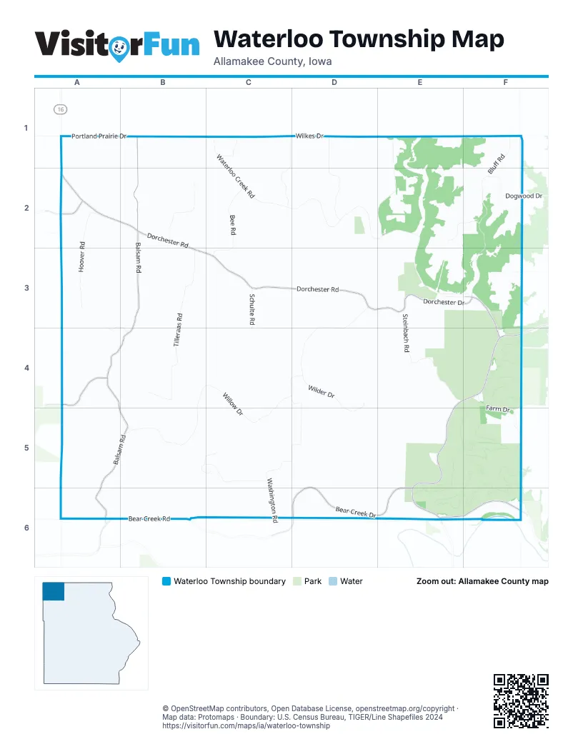
Street index of Waterloo Township
Each street on the sheet and the grid squares it crosses.
- Portland Prairie DriveA1, B1
- Balsam RoadB1, B2, B3, A4, B4, A5, B5, A6
- Blue Jay DriveC1
- Homewood Hill RoadC1, C2
- Homewood Hills RoadC1
- Waterloo Creek RoadC1, C2, D2, E2, E3, F3
- Wilkes DriveC1, D1
- Lindy Hill RoadD1, D2
- Ranzenberger RoadD1, E1, E2
- Bluff RoadF1, F2, F3
- State Line RoadF1
- Wiegrefe RoadF1
- 113th AvenueA2
- 380th StreetA2
- Dorchester RoadA2, B2, B3, C3, D3, E3
- Hoover RoadA2, A3
- Lilac DriveA2
- North View RoadB2
- Bee RoadC2, C3
- Meyer DriveE2, F2
- Dogwood DriveF2
- Jahnke DriveA3, B3, A4, B4
- Tilleraas RoadB3, B4
- Schulte RoadC3, C4
- Washington RoadD3, C4, D4, C5, D5, C6
- Bench StreetE3
- Center StreetE3, F3
- Dorchester DriveE3, F3, F4
- Steinbach RoadE3, E4
- Archa RoadF3
- Cliff RoadF3
- Dachester DriveF3
- Juniper DriveF3
- Quandahl RoadA4
- Willow DriveB4, C4, B5, C5
- Wilder DriveD4, D5
- State Highway 76E4, F4, E5, E6
- Farm DriveF4, F5
- Bear Creek Public AccessA5
- Old Bridge RoadA5
- Tahigwa CampB5, C5
- Tahigwa DriveC5
- Dead Horse HollowF5
- Bear Creek RoadA6, B6
- Bear Creek DriveD6, E6
- Iowa River DriveE6, F6
Places on the map
- Camp Tahigwa Landing Site Heliport
- Saint Johns Methodist Cemetery
- Saint Mary Catholic Church
- Saint Marys Cemetery
- Waterloo Creek Wildlife Management Area
- Waterloo Ridge Cemetery
- Waterloo Ridge Church
- West Waterloo Ridge Cemetery
© OpenStreetMap contributors, Open Database License, openstreetmap.org/copyright · Map data: Protomaps · Boundary: U.S. Census Bureau, TIGER/Line Shapefiles 2024