

Idaho map
Ammon map
About 20,095 people live here (Census Bureau, 2024 estimate). The sheet's index lists 295 streets; South Ammon Road, Ross Avenue and East Sunnyside Road cross the most grid squares. Also on it: Big Lost Trail, Ammon Town Center and Hillcrest High School.
Open the map (PDF, US Letter)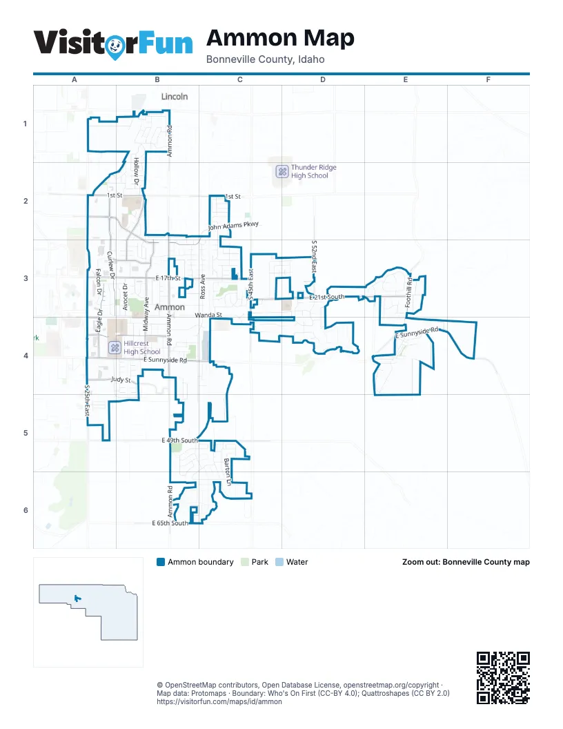
Street index of Ammon
Each street on the sheet and the grid squares it crosses.
- Beulahs LaneA1
- East 14th NorthA1, B1
- Bergeson DriveB1, B2
- Coulter WayB1
- East Bent Grass DriveB1
- East Lincoln RoadB1
- East Sky Mountain CourtB1
- Greenwillow LaneB1
- Hollow DriveB1, B2
- Indian Hollow DriveB1
- North Ammon RoadB1
- North Blue Grass LaneB1
- North Curlew DriveB1, A2, B2
- North Northwind DriveB1
- North Robin AvenueB1
- Pearce DriveB1
- SilvermapleB1, B2
- Sparrow Hawk CourtB1
- Sparrow Hawk DriveB1
- Terrill DriveB1
- Trappers Ridge DriveB1
- 1st StreetA2, B2, C2
- Brooklyn StreetA2, B2
- Curlew DriveA2, A3
- Diamond CircleA2, A3
- John Adams ParkwayA2, B2, C2, B3
- Sydney DriveA2, B2
- Abigail CourtB2, B3
- Advantage LaneB2
- Backhand DriveB2
- Church StreetB2
- Clara CourtB2
- Clover LaneB2
- Court PlaceB2
- Cross CircleB2
- Cross LaneB2
- East Kit LaneB2
- Ellendale CircleB2
- Fennec LaneB2
- Katie CourtB2
- Leroy DriveB2
- Luv PlaceB2
- Matchpoint DriveB2, B3
- Maurine DriveB2
- Midway AvenueB2, B3, B4
- Raquet PlaceB2
- Red Fox DriveB2
- Silkwood CircleB2, B3
- Silver CircleB2
- South Adam LaneB2, B3
- South Ammon RoadB2, B3, B4, B5, B6
- Steinfeld DriveB2
- Tennis Court DriveB2
- Tie Breaker DriveB2, B3
- Victoria StreetB2
- Wimbledon CircleB2
- BrackenC2
- Bridger DriveC2
- Crimson DriveC2
- Ensign DriveC2
- FairviewC2
- Holladay CircleC2
- Holladay DriveC2
- Mathews DriveC2
- Newgate DriveC2, C3
- Robison DriveC2
- RulonC2
- Chasewood DriveA3, B3
- Dove DriveA3
- Eagle DriveA3, A4
- East 17th StreetA3, B3, C3
- Falcon DriveA3
- Salmon StreetA3, B3
- Sapphire DriveA3
- Sawtooth StreetA3, B3
- Teton StreetA3, B3
- Ashland DriveB3
- Avocet DriveB3
- Bittern DriveB3
- Brettonwood DriveB3
- Briar Creek CircleB3
- Briar Creek LaneB3
- Brookfield LaneB3, C3
- Cabellaro DriveB3
- Canyon Park RoadB3
- Circle South DriveB3
- Del Rio CircleB3
- Devonwood DriveB3
- Edinburg CircleB3
- Glen Cove DriveB3
- Greenfield DriveB3
- Heartland CircleB3
- Heather CircleB3
- Heather LaneB3
- Hillam DriveB3, B4
- Jackson DriveB3
- Kingswood CircleB3
- Madeline DriveB3
- Market WayB3
- Meadowbrook CircleB3
- Oakmeadow CircleB3
- Orchard CircleB3, C3
- Ridgeview CircleB3, C3
- Ross AvenueB3, C3, B4, C4, B5
- Sabin DriveB3
- San Carlos StreetB3
- Selway StreetB3
- Senoma CircleB3
- Silverwood CircleB3
- Southwick LaneB3
- Spencer LaneB3
- Summerridge CircleB3
- Sunburst DriveB3
- Sunflower CircleB3
- Targhee StreetB3
- Trailwood DriveB3
- Villa Vista DriveB3
- Wanda StreetB3, C3, C4
- Wasatch CircleB3
- Williams StreetB3
- Windsor DriveB3
- 19th StreetC3, D3
- Amber LaneC3
- Ballagio DriveC3
- Benchmark CircleC3
- Bergamo CourtC3
- Birchwood CircleC3
- Bridge Gate CircleC3
- Cassidy DriveC3
- Cherrywood CircleC3
- Christy LaneC3
- Cobie LaneC3
- Countryside CircleC3
- Dakota LaneC3
- Eagle Pointe CourtC3
- Eagle Pointe DriveC3
- Eagles Homestead DriveC3
- East 21st SouthC3, D3, E3
- Eastwood CircleC3
- Edgewood CircleC3
- Forest Glen DriveC3
- Frontier DriveC3
- Gateway CircleC3
- High Desert DriveC3
- Ileen CircleC3, C4
- Jessica LaneC3
- Jordan CircleC3
- Laura CircleC3
- Luxor DriveC3, D3
- Mandalay DriveC3
- Marlene StreetC3
- Mirinda LaneC3
- Morning Mist CircleC3
- Morning Mist DriveC3
- Princess DriveC3
- Ridgewood DriveC3
- South 45th EastC3, C4
- Torcello DriveC3, D3
- Wildwood LaneC3
- Willow Canyon CourtC3
- Willow Canyon DriveC3
- Winchester DriveC3
- Woodside CircleC3
- Brennan BendD3
- Brennan PlaceD3
- East Casa Grande DriveD3
- Fieldstone CourtD3
- Fieldstone DriveD3, D4
- Lindee LaneD3
- Marsala CourtD3
- South 52nd EastD3
- South Castelli DriveD3
- Stafford CircleD3
- Stafford DriveD3, D4
- 60th EastE3
- Bobwhite DriveE3
- East Lydia StreetE3
- Foothill RoadE3, E4
- Grouse Hen DriveE3
- Hungarian WayE3
- Partridge CourtE3
- Partridge WayE3
- Pheasant DriveE3
- Pine Hen LaneE3
- Ptarigan WayE3
- Quail Ridge DriveE3
- Sage Hen CourtE3
- Sage Hen LaneE3
- Sharptail RoadE3
- South 60th EastE3
- Brianne AvenueA4
- East Sunnyside RoadA4, B4, C4, E4, F4
- Jafer CourtA4
- Judy StreetA4, B4
- Knight WayA4
- South 25th EastA4, A5
- Stonehaven DriveA4, B4
- Taylorview LaneA4, A5, B5
- Woodking DriveA4
- Aspen LaneB4, C4
- Aston Villa RoadB4
- Brookstone CircleB4
- Brownstone CircleB4
- Carolyn LaneB4
- Central AvenueB4
- Chelsea RoadB4
- Courtyard CircleB4
- Dal AvenueB4
- Geneva DriveB4
- Georgia LaneB4, C4
- Goldfinch WayB4, B5
- Hearthstone CircleB4
- Hidden HavenB4
- Hillcrest Ranch RoadB4
- Liverpool RoadB4
- Maiben StreetB4, C4
- Meadow LaneB4
- Molen StreetB4
- Mountain Bluebird WayB4, B5
- Northern Harrier WayB4
- Oakhaven CircleB4
- Oakwood CircleB4
- Owen StreetB4
- Rawson StreetB4
- Rich LaneB4
- Romrell LaneB4
- Rosedale LaneB4
- Ross CircleB4
- Samuel CircleB4
- Samuel StreetB4
- South Hidden HavenB4
- Springstone CircleB4
- Stonegate DriveB4
- Stonehaven CircleB4
- Stoneridge CircleB4
- Stonewood CircleB4
- Summerwood CircleB4
- Summerwood LaneB4, B5
- Talmage StreetB4
- Vaughn StreetB4
- Virginia DriveB4
- Western AvenueB4
- Willowwood CircleB4
- Lady Hawk LaneC4, D4
- Majestic View DriveC4
- Mason StreetC4
- Bungalow DriveD4
- Cabana DriveD4
- Hidden Hutch CircleD4
- Hidden Hutch DriveD4
- Stafford CourtD4
- Tildy CircleD4
- Tildy LaneD4
- Boulder Creek LaneE4
- Chartwell GardenE4
- Crown CrescentE4
- Founders Pointe CircleE4
- Founders Pointe CourtE4
- Founders Pointe DriveE4
- Hillsdale LaneE4
- Mansion Hill DriveE4
- South Laurelwood DriveE4
- Tabitha TrailE4
- Tower Castle LoopE4
- Triumph DriveE4
- Aggie WayA5
- Commodore RoadA5
- East 49th SouthA5, B5, C5
- Gator AlleyA5
- Razorback RoadA5
- Rebel RoadA5
- South Wackerli AvenueA5
- AutumnwoodB5
- Clearfield DriveB5, B6
- Clearfield LaneB5, C5
- Coopers Hawk WayB5
- Millcreek LaneB5, C5
- Veil DriveB5, B6
- Vintage LaneB5, C5
- Windmill DriveB5
- Barton CircleC5
- Barton CourtC5
- Barton LaneC5, C6
- Barton PlaceC5
- Chimney Rock DriveC5
- Lakefield LaneC5, B6
- Liberty DriveC5
- Lily LaneC5
- Remember DriveC5
- Rocky Ridge RoadC5
- Thunder DriveC5, C6
- Treyden CircleC5
- Treyden DriveC5, C6
- East 65th SouthB6, C6
- Tawzer WayB6, C6
Places on the map
- Ace Hardware
- Agave Grille
- Albertsons
- Ammon City Swimming Pool
- Ammon Elementary School
- Ammon Fire Department
- Ammon Town Center
- Big Lost Trail
- Broulim's
- Cabela's
- Chase
- Culver's
- Eagles Homestead Park
- Elite Auto Sales
- Hawthorn Park
- Hillcrest High School
- Hillview Elementary School
- Hobby Lobby
- IHOP
- Kohl's
- Lions Park
- McCowin Park
- Petco
- Peterson Park
- Rimrock Elementary School
- Romaine's
- Sandcreek Commons
- Sandcreek Middle School
- Shell Express
- Snake River Montessori School
- Sonic
- Splash Pad
- Staples
- Sunnyside Gardens
- Target
- The Church of Jesus Christ of Latter-day Saints
- Tiebreaker Elementary
- Walmart Supercenter
- White Pine Charter School
- Zions Bank
Next to Ammon
- Lincoln
© OpenStreetMap contributors, Open Database License, openstreetmap.org/copyright · Map data: Protomaps · Boundary: Who's On First (CC-BY 4.0); Quattroshapes (CC BY 2.0)















