

Idaho map
Bonneville County map
About 133,644 people live here (Census Bureau, 2024 estimate). The sheet's index lists 300 streets; Swan Valley Highway, Grays Lake Road and Bone Road cross the most grid squares. Things to do inside the boundary: Grand Teton Mall, Idaho Falls Zoo At Tautphaus Park and Museum of Idaho.
Open the map (PDF, US Letter)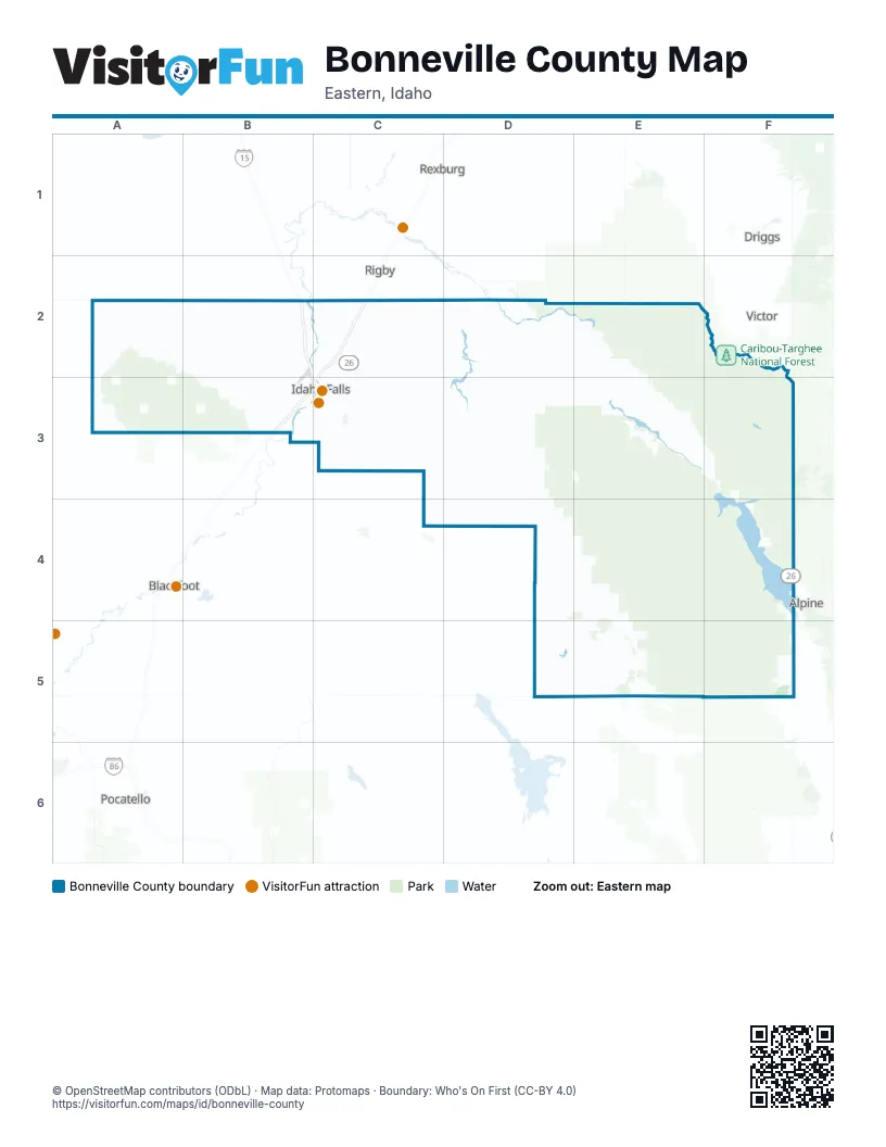
Maps inside Bonneville County
2 maps inside, from the street map of Bonneville County down.
Street index of Bonneville County
Each street on the sheet and the grid squares it crosses.
- Veterans Memorial HighwayB2, B3, C3
- Swan Valley HighwayC2, D2, E2, E3, F3, F4
- West Arco HighwayA2, B2, B3
- East Ririe HighwayC2, D2
- East Sunnyside RoadC3
- West Broadway StreetB3, C3
- Pine Creek RoadE2, E3
- North Yellowstone HighwayC2
- North 25th EastC2, C3
- South 25th EastC3
- North 15th EastC2
- North 5th EastC2
- West 65th SouthB3, C3
- South Yellowstone HighwayB3, C3
- East 145th North / East County Line RoadC2, D2
- South 45th WestB3
- East 17th StreetC3
- East 105th NorthC2
- East County Line RoadC2
- State Highway 31E2, F2
- West Sunnyside RoadB3, C3
- Pancheri DriveB3, C3
- South Woodruff AvenueC3
- Grandview DriveB3, C3
- North Woodruff AvenueC2, C3
- Northgate MileC2, C3
- Science Center DriveC2
- North Holmes AvenueC2, C3
- Yellowstone AvenueC3
- North 130th EastD2
- East Anderson AvenueC2
- West 17th StreetC3
- West Ririe HighwayD2
- Lincoln RoadC2
- North 800 EastB3
- Idaho Medal of Honor HighwayA2
- South Fork DriveF3
- East Lincoln RoadC2
- North 45th EastC2, C3
- North 5th WestC2
- 1st StreetC3
- East Iona RoadC2
- East 65th SouthC3
- South Ammon RoadC3
- South Holmes AvenueC3
- South 15th EastC3
- South 1st EastC3
- South 45th EastC3
- South 5th WestC3
- West 145th North / East County Line RoadB2, C2
- North Ammon RoadC2, C3
- West 81st SouthB3, C3
- Fremont AvenueC2, C3
- North Skyline DriveB2, B3
- South Utah AvenueB3, C3
- Channing WayC3
- Lomax StreetC3
- South Skyline DriveB3
- Memorial DriveC3
- West 145th NorthB2
- Riverside DriveC3
- West 129th SouthC3
- East 1300 NorthC3
- 1 st StreetC3
- West 145 NorthB2
- 5th WestC3
- Main StreetD2
- National Forest Development Road 077D3, E3, E4
- National Forest Development Road 058E3, F3, F4
- Grays Lake RoadD4, E4, D5, E5
- Dan Creek RoadD3, D4, E4
- Bone RoadC2, C3, C4, D4
- Meadow Creek RoadD2, D3
- Kepps Crossing RoadC3, D3
- West 65th NorthB2, C2
- West 113th NorthA2, B2, C2
- North 26th WestB2, B3
- North 35th WestB2, B3
- North 55th EastC2, C3
- East 113th NorthC2
- West 81st NorthB2, C2
- North 115 EastC2, C3
- Old Irwin RoadE3
- North 105th WestB2
- West 17th SouthB3
- North River RoadB2, C2
- West 49th NorthB2
- East 49th NorthC2
- West 129th NorthB2, C2
- East 81st NorthC2
- East 49th SouthC3
- East 97th NorthC2
- West 33rd NorthB2, C2
- South 65th WestB3
- South 35th WestB3
- West 33rd SouthB3
- West 49th SouthB3, C3
- East 65th NorthC2
- East 25th StreetC3
- John Adams ParkwayC3
- State Line RoadF5
- South 55th WestB3
- North 85th EastC2
- East 97th SouthC3
- South 15th WestB3
- West 17th NorthB2
- North Foothill RoadC2
- Lindsay BoulevardB2, C3
- North 55th WestB2, B3
- North 75th EastC2
- Snake River ParkwayB3
- East Foothill RoadC2
- East 113th SouthC3
- Foothill RoadC2, C3
- Palisades Creek RoadE3, F3
- North 1200 East / South 5th WestC3
- East 1600 North / West 81st SouthB3
- Eagle PassC3
- 12th StreetC3
- South BoulevardC3
- North 35th EastC2
- North 45th WestB2, B3
- Blackfoot Reservoir RoadC4
- East 21st SouthC3
- South Pioneer RoadB3, C3
- Saint Clair RoadC3
- North BoulevardC2, C3
- North 175th EastD2
- 9th StreetC3
- South Bellin RoadB3
- North 115th EastC2
- Curlew DriveC3
- North 65th WestB2, B3
- Midway AvenueC3
- East 129 NorthC2
- Garfield StreetC3
- East 73rd SouthC3
- South 52nd EastC3
- Hoopes AvenueC3
- Judy StreetC3
- East 1500 North / West 97th SouthB3, C3
- East Elva StreetC3
- 11th StreetC3
- Rollandet AvenueC3
- North 160th EastD2
- East 143rd NorthD2
- Eagle DriveC3
- South 10th EastC3
- South Pioneer DriveB3
- Stoltenberg LaneE3
- East 129th SouthC3
- Hemmert AvenueC2
- Jefferson AvenueC2, C3
- Castlerock LaneC3
- Grizzly AvenueB3
- Stonebrook LaneC3
- Tie Breaker DriveC3
- South 60th EastC3
- East 33rd NorthC2
- Owen StreetC3
- South Capital AvenueC3
- West Elva StreetC3
- North Lee AvenueC3
- I StreetC3
- West Anderson AvenueC2
- Ashment AvenueC3
- West 97th SouthB3, C3
- Park AvenueC3
- South Saturn AvenueB3
- Outlet BoulevardB3
- Event Center DriveB3
- Wadsworth DriveC2, E3
- Saturn AvenueB3
- Chasewood DriveC3
- West 113th SouthC3
- Iona North RoadC2
- 5th StreetC3
- North Fanning AvenueC3
- 6th StreetC3
- Old Butte RoadB3
- West 97th NorthC2
- Chamberlain AvenueC3
- Owens AvenueC2
- South Fork BoulevardB3
- Elm StreetC3
- North Bellin RoadB3
- East Stanley StreetC2
- Iona RoadC2
- E StreetC3
- F StreetC3
- Dunbar DriveC2, C3
- Knight WayC3
- North Utah AvenueC3
- Creamery RoadF5
- D StreetC3
- South Pioneer LaneB3
- East 29th NorthC2
- Birch StreetC3
- Moonbeam DriveC2
- Horse Creek RoadD4
- Cliff StreetC3
- North Bassett RoadB2
- National Forest Development Road 157 TrailD3
- Brianne AvenueC3
- North 1325 EastC3
- East 129 SouthC3
- North 4100 EastC2
- 73rd SouthC3
- Long Valley RoadD4
- East 1600 NorthB3
- Temple PlaceC3
- West Anderson StreetC2
- North 3800 EastC2
- North 4000 EastC2
- Pioneer LaneB3
- 115th Road EastC2
- North 3700 EastC2
- National Forest Development Road 087E4, F4
- Trail Creek RoadD2, D3
- East Heise RoadD2, E2
- Birch Creek RoadD2
- Kepps Crossing Rd/ Skyline Rd NF-077D3, D4, E4
- Brockman RoadD4, E4, E5
- East 129th NorthC2
- North 125th WestB2
- Rainey Creek RoadE3, F3
- West Side RoadE5
- Harris DugwayD2, D3
- Pine Creek Bench RoadE2, E3
- National Forest Development Road 063E4, F4
- North 95th EastC2
- North 135th WestB2
- Antelope Flat RoadD2, E2
- Antelope Creek RoadD2, D3
- Cranes Flat RoadD4, D5
- National Forest Development Road 253F2
- Taylor Mountain RoadC3
- North 115th WestB2, B3
- National Forest Development Road 250E2
- Indian Fork RoadD3
- National Forest Development Road 189E5
- National Forest Development Road 017E4
- National Forest Development Road 070F5
- Black Moutain TrailF5
- National Forest Development Road 136F5
- North 75th WestB2
- 65th Road WestB2
- 65th Road NorthC2
- National Forest Development Road 035D3
- Sheep Creek RoadF3
- National Forest Development Road 084D4
- Chapel RoadE3
- Cutthroat RunF3
- Blue Creek RoadD3
- Traughber RoadE3
- National Forest Development Road 217D2
- Bridge Creek RoadE5
- East Sagewood DriveC3
- National Forest Development Road 151D4, E4
- 9th Road SouthC3
- East 81st SouthC3
- North 65th EastC2
- Mann RoadE4
- Moss Avery RoadD2
- Ross AvenueC3
- National Forest Development Road 385D3
- Indian Creek RoadF4
- Greenwillow LaneC3
- Cottonwood RoadE3
- Pipe Creek RoadD3
- 33rd Road NorthC2
- South Higbee AvenueC3
- Willow Creek RoadE5
- National Forest Development Road 065E3
- East Panorama DriveC2
- 49th Road SouthC3
- South Indian RoadF4
- National Forest Development Road 389F5
- South Emerson AvenueC3
- South Lee AvenueC3
- Little Elk Creek RoadF3, F4
- North 70th EastC2
- South Huff RoadC3
- Sumac LoopE3
- East 109th NorthC2
- 10th StreetC3
- Conant Valley Loop RoadE3
- Fairview RoadC2
- North 105 EastC2
- Packbridge LaneC3
- East 16th StreetC3
- 97th Road NorthB2, C2
- Elk Ridge Drive Chapel RoadE3
- North 80th EastC2
- Ranger Station RoadE3
- Milligan RoadB3, C3
- Henry Creek RdC3
- Buck RoadC2
- Swan LaneE3
- Big Elk Creek RoadF4
Things to do on the Bonneville County map
Places on the map
- Ammon
- Ammon Town Center
- Big Lost Trail
- Bonneville County Fairgrounds
- Bonneville County landfill (Sunnyside)
- Bonneville High School
- Community Park
- Community Park Trail
- Falls Campground
- Flying J Travel Center
- Gem Lake Bike Park
- Grand Teton Mall
- Grays Lake
- Grays Lake National Wildlife Refuge
- Hells Half Acre Wilderness Study Area
- Hillcrest High School
- Hitt Gravel Pit
- HK Contractors
- Idaho Canal
- Idaho Falls
- Idaho Falls Greenbelt
- Iona
- Irwin
- Knife River
- Lava Loop Trail
- Little Valley Reservoir
- Love's Travel Stop
- Lower Palisades Lake
- Old Butte Park
- Palisades Reservoir
- Ririe Reservoir
- Rose Hill Cemetery
- Sage Lakes Golf Course
- Sand Creek Golf Course
- Snake River Landing Park
- Swan Valley
- Ucon
- Upper Palisades Lake
- West Piney Recreation Camp
- Willow Creek Pit
Next to Bonneville County
- Alpine
- Blackfoot map
- Driggs
- Pocatello map
- Rexburg map
- Rigby
- Victor
© OpenStreetMap contributors, Open Database License, openstreetmap.org/copyright · Map data: Protomaps · Boundary: Who's On First (CC-BY 4.0); Quattroshapes (CC BY 2.0)















