

Idaho map
Bonner County map
About 53,955 people live here (Census Bureau, 2024 estimate). The sheet's index lists 300 streets; Eastshore Road, Mountain View Road and Railroad Avenue cross the most grid squares. Things to do inside the boundary: Lake Pend Oreille Cruises, Priest Lake Chamber of Commerce and Sandpoint.
Open the map (PDF, US Letter)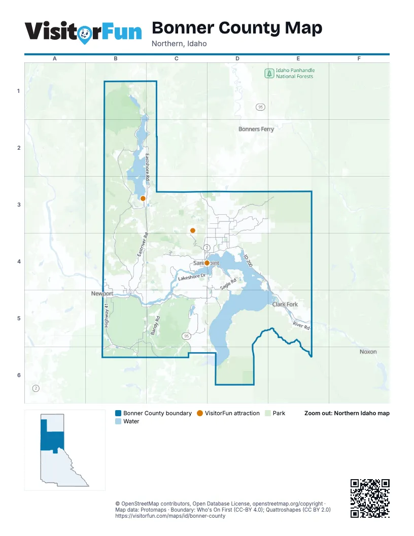
Street index of Bonner County
Each street on the sheet and the grid squares it crosses.
- ID 200D4, E4, E5
- Highway 41B5, B6
- Railroad AvenueC4, D4, B5, E5
- Cedar StreetC4, D4, B5, E5
- Sand Creek BywayC4, D4
- Pine StreetB4, C4, B5, E5
- Albeni RoadB5
- North 5th AvenueC4
- Long BridgeD4
- 4th AvenueE5
- South 1st AvenueC4
- Dover BridgeC4
- North 1st AvenueC4
- North State AvenueB5
- East Superior StreetC4, D4
- State Highway 57B2, B3, B4, B5
- North Boyer AvenueC4
- Schweitzer Cutoff RoadC4
- South Boyer AvenueC4
- Eastshore RoadB1, C1, B2, C2, C3
- Dufort RoadB5, C5
- Eastriver RoadB3, C3, B4, C4
- Baldy Mountain RoadC4
- Grouse Creek RoadD3, E3, D4
- Eastside RoadB4, B5
- Spirit Lake Cutoff RoadB5, C5, B6
- Reeder Bay RoadB1, B2
- Sagle RoadC4, D4
- Rapid Lightning Creek RoadD3, E3, D4
- Colburn Culver RoadD3, D4
- Clagstone RoadB5, C5, B6, C6
- Bottle Bay RoadD4
- Schweitzer Mountain RoadC4
- Blacktail RoadC5
- River RoadE5
- Upper Gold Creek RoadD3
- Upper Pack River RoadC3, D3
- Peninsula RoadB4, D4
- Talache RoadD4, D5
- Old Priest River RoadB5
- Hoo Doo LoopB5
- Dickensheet RoadB3
- Denton RoadD4, E4, E5
- Freeman Lake RoadB4, B5
- South Sagle RoadC4, C5, D5
- Wrenco LoopC4
- Cocolalla Loop RoadC5
- Cavanaugh Bay RoadB3, C3
- Little Blacktail Mountain RoadC5, D5
- West Pine StreetC4
- East Dufort RoadC5, D5
- Samuels RoadD3
- North Kootenai RoadD4
- East Settlement RoadB5
- North Boyer RoadC4
- Bayview RoadC5, C6
- North Center Valley RoadD3
- Gold Creek RoadD3
- Johnson Creek RoadE5
- East Selle RoadC4, D4
- Center Valley RoadD3
- Selle RoadD4
- Blanchard-Elk RoadB5, B6
- Bodie Canyon RoadB4, B5
- Hickey RoadD4
- Main StreetC4, D4, B5, E5
- East Shingle Mill RoadD4
- South Center Valley RoadD3, D4
- Bluebird LaneD4, B5, E5
- Garfield Bay RoadD4, D5
- Jacobson RoadD4
- Larch StreetC4, B5
- Grouse Creek Cut Off RoadD3
- 4th StreetB4, C4, D4, B5
- Shingle Mill RoadD4
- Le Clerc RoadB4, B5
- Wellington PlaceD4
- Oak StreetC4
- Gold Creek CutoffD3
- Church StreetC4, B5
- Tweedie RoadB5
- Langille Canyon RoadB4
- North Division AvenueC4
- Ontario StreetC4
- Shannon LaneC4, B5
- Gold Mountain DriveD4
- West Main StreetD4
- Holly Glenn RoadB5
- Kootenai Cutoff RoadC4, D4
- North 3rd AvenueC4, B6
- South Lincoln AvenueC4
- South River RoadE5
- Idaho Forest Industries Mill RoadB5
- North Stephen StreetE5
- North Main StreetD4
- Wisconsin StreetB5
- North Clagstone RoadC6
- Centennial BoulevardD4
- Kootenai Cut Off RoadC4
- National Forest Development Road 278D5, E5, D6
- National Forest Development Road 2550B5
- Trestle Creek RoadD4, E4
- Lightning Creek RoadE3, E4, E5
- Lakeshore DriveC4, D4, C5
- Indian Mountain RoadB2
- National Forest Development Road 332D5, E5, D6
- Forest Service Road 278D6
- Kelso Lake RoadB5, C5, C6
- Sunnyside RoadD4
- Pend Oreille Divide RoadD6
- USFS Road 1021E5
- USFS Road 2076D5
- Gleason McAbee RoadB3, B4
- Elmira RoadD3
- Tower Mountain RoadB5
- Prater Mountain RoadC4
- West Lakeshore RoadB2, B3
- East Spring Creek RoadE4, E5
- Bear Paw RoadB4
- Upper Priest River RoadB1
- North Nordman RoadB2
- Gleason-Mcabee Falls RoadB3
- Bandy RoadC5
- Jewel Lake RoadC5
- Lower Quartz Creek RoadB4
- Eureka RoadD4
- Cottonwood RoadB3, B4, E5
- Green Bay RoadD4, D5
- National Forest Development Road 208E5
- Vay RoadC5
- Flume Creek RoadD3, E3
- North Riley Creek RoadC4, C5
- Upper Manley Creek RoadC4, C5
- Callahan Creek RoadE3
- Kalispell Creek RoadB2
- North ForkD3
- National Forest Development Road 2236D3
- Trapper Creek RoadD3, E3
- Woodrat RoadB3
- Big Creek RoadB4, C4
- Squaw Valley RoadB3
- National Forest Development Road 489E4
- West Spring Creek RoadD4, E4
- Lamb Creek RoadB3
- White Tail Butte RoadB3
- Peterson RoadB4
- National Forest Development Road 419E4, E5
- Sunset RoadC5
- Tower RoadC4, C5
- Trout Creek RoadD4
- National Forest Development Road 903D6
- Auxor Basin RoadE4
- National Forest Development Road 1180D6
- Hammond Ranch RoadB4
- Selkirk RoadD3, D4
- Zephyr Hills DriveC3, D3
- Westmond RoadC5
- Poirier RoadB5, B6
- Hidden Valley RoadC4, D4, B5
- Blanchard Cutoff RoadB5
- Mosquito Creek RoadB4, E5
- National Forest Development Road 1066D5
- Fish Creek RoadC5
- South Idaho Club DriveD4
- Whittum RoadB5, C5
- Barnhardt RoadC5
- HooDoo Mountain RoadB5
- Van Dyke RoadE3
- Cabin Ridge RoadB5
- Merril Martin RoadC4
- Quartz Creek RoadB4
- Forest Service Road 2707D6
- Elk LoopD3
- Lower Pack River RoadD4
- Big Buck RoadD6
- Peninsula Loop RoadB4
- Forest Service Road 630C5, D5
- Johnsons CutoffB4
- Tanglefoot TrailB3, C3
- Greenhood RoadB3
- Vintage 95 RoadC6
- Butler Creek RoadC5, D5
- Mineral Ridge RoadC6
- Old Range RoadE5
- West Settlement RoadB4, B5
- Highlands RoadD3
- Gun Club RoadC4
- Wellington Creek RoadE4
- Galena Valley Mill Creek RoadB3
- Mountain View RoadC4, E4, B5, E5, B6
- Reeder Creek RoadB2
- Kalispell Bay RoadB2
- Ragstad Powerline RoadB5, B6
- Camp Bay RoadD4
- Wooded Acres DriveC4
- National Forest Development Road 2670D3
- Stone RoadB5
- Meadowlark LaneC4, D4, B5
- Gypsy Bay RoadC4
- Roop RoadC5
- Algoma Spur RoadC4, C5
- Cork RoadB5, C5
- Strawberry Creek RoadD3, E3
- Bowen Arrow RoadD3
- Box CanyonD3
- IDL 12B3, C3
- Kendall RoadC5
- Southside School RoadC5
- Evergreen RoadD3, C4
- Helen Thompson RoadC4
- IDL 173B3
- Pup Paw TrailB4
- Cross Mountain RoadD3, E3
- Garfield Bay CutoffD4, D5
- Hulett Hill DriveD3
- Estates LoopC5
- Cabinet Gorge RoadE5
- Hughes Meadow RoadB1
- Thimbleberry LaneD4
- F South Road 297C6, D6
- Lignite RoadC4, D4
- Elliot Bay RoadD4
- Sky Meadow RoadD4
- Cohage RoadD3
- Dormar DriveD4, D5, E5
- Moonfire RoadD3
- Curtis Creek RoadB5, C5
- Cedar View Estates RoadB5
- Spades RoadC4
- Homestead RoadC6
- National Forest Development Road 277E5
- Camp Cudge RoadB2, C2
- Berry Canyon RoadC3, D3
- Mirror Lake RoadB4, D5
- Hines RoadD3
- Otts Basin RoadC4, C5
- Hornby Creek RoadC4
- Mud Gulch RoadB3, C3
- Forest Siding RoadD3, D4
- Upper Samuels RoadD3
- Carr Creek RoadC4
- Blue Lake RoadB4, C4
- Fairway DriveB3, B6
- Gold Cup Mountain RoadC5
- Cape Horn RoadB2, C2
- Sanborn Creek RoadB4
- Tanglewood DriveB3
- Old HighwayD4, C5
- Trask Pond RoadB5
- Cresthaven DriveC4
- Ridgeline TrailC4
- Gooby RoadC4
- Lakeview RoadD6
- Rabbit Run RoadC5
- National Forest Development Road 280E3
- Ponderosa RoadD5
- Eichs RoadC5
- Crows Nest LaneE5
- Iron Horse LoopD3
- Torrens TrailB5, C5
- Lost Creek RoadB3, C3
- Edgemere CutoffC5
- West Johnson Creek RoadC4
- Rodgers RoadC4
- Sagle Creek RoadD4, D5
- Thomspon RoadB3
- Hoop LoopB5
- Albeni Cove RoadB5
- National Forest Development Road 2295E5
- Old Mill RoadD3
- Black Trail RoadD5
- Meadowood RoadD3
- Rolling Thunder Ridge RoadD3
- Old Homestead RoadC5
- Glengary Bay RoadD4
- West Oden Bay RoadD4
- Riverside RoadB5
- A StreetD3
- Sherwood Beach RoadB3
- Mogul HillC4
- Condon Ranch RoadB5, C5
- High Meadow DriveB5
- County Road 22C6
- Johnny Long RoadC4
- West Elmira RoadD3
- Paisley RoadB6
- ElmiraD3
- Midas DriveD5
- Ravin Ranch RoadB2
- National Forest Development Road 2649C6
- West Shingle Mill RoadD4
- Neopit View Loop RoadB3
- Dunromin RoadC5
- Cascade Creek RoadE5
- Long Mountain RoadC5
- Woodside RoadD3, D4
- Old House RoadC6
- Faset PeakD6
- Homestead LoopC4
- Beers Humbird DriveC5
Things to do on the Bonner County map
Places on the map
- Armstrong Meadows
- Bear Creek Fen
- Big Meadows
- Binarch Creek Research Natural Area
- Bismark Meadows
- Blanchard Lake
- Blue Lake
- Boswell Kings Lake Road C
- Chase Lake
- Clagstone Meadows Natural Area
- Clark Fork
- Comeback Bay
- Daggett Meadow
- Dover
- Dover Pit
- Dubius Creek Fen
- East Hope
- Five Lakes Estates
- Flume Trail
- Freeman Lake
- Gamlin Lake
- Gamlin Lake Recreation Site
- Gleason Meadow
- Hill's Resort
- Hoodoo Lake
- Hope
- Indian Creek Campground
- Kalispell Island Trail
- Kelso Lake
- Kootenai
- Lake Cocolalla
- Lake Pend Oreille
- Lake San Souci
- Lamb Creek Meadows
- Linscott Gravel
- Luby Bay Campground
- Pend Oreille Wildlife Management Area
- Priest River Experimental Forest
- The Idaho Club
- Upper Priest Lake Scenic Area
Next to Bonner County
- Bonners Ferry
- Newport
- Noxon
© OpenStreetMap contributors, Open Database License, openstreetmap.org/copyright · Map data: Protomaps · Boundary: Who's On First (CC-BY 4.0); Quattroshapes (CC BY 2.0)















