

Idaho map
Chubbuck map
About 16,577 people live here (Census Bureau, 2024 estimate). The sheet's index lists 247 streets; Yellowstone Avenue, Whitaker Road and Hawthorne Road cross the most grid squares. Also on it: Park Meadows, Pine Ridge Mall and Bicentennial Park.
Open the map (PDF, US Letter)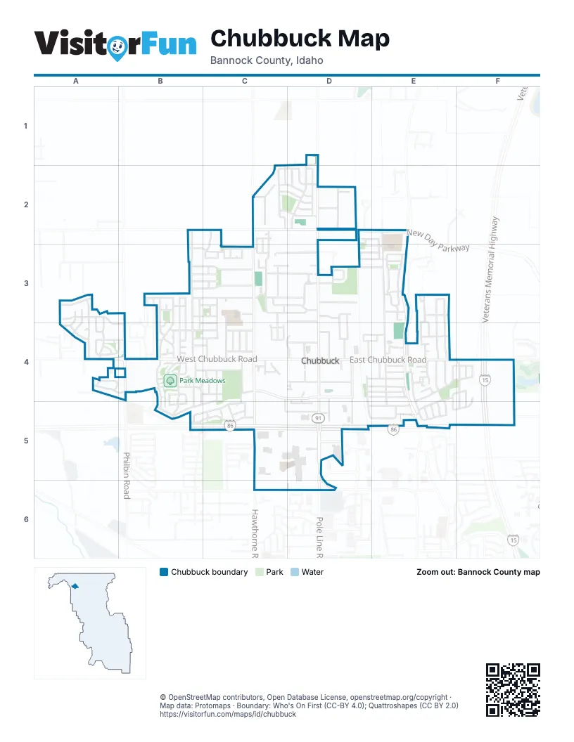
Street index of Chubbuck
Each street on the sheet and the grid squares it crosses.
- Ruth StreetC1, C2
- Bringhurst StreetD1
- Eden StreetD1, D2
- North Yellowstone HighwayD1
- Yellowstone AvenueD1, D2, D3, D4, D5, D6
- Cole StreetB2, B3, B4
- Abraham StreetC2, D2
- Calen LaneC2, C3
- Eve StreetC2
- Garden Oaks CircleC2
- Jacob StreetC2, D2
- Joel StreetC2, D2
- Josh WayC2, C3
- Lariat LaneC2
- Noah StreetC2, D2
- Oaktrails DriveC2
- Sorrel StreetC2
- Stuart AvenueC2, C3, D3
- Trueman StreetC2, C3
- West Siphon RoadC2, D2
- David StreetD2
- Delaware StreetD2, D3
- Industry WayD2
- Isaac StreetD2
- Moses StreetD2
- New Day ParkwayD2, E2
- Northside CrossingD2
- Pocano StreetD2, E2
- Southside WayD2
- North Hiline RoadE2, E3, E5
- Shenendoah DriveE2, E3
- Whitaker RoadE2, E3, E4, E5
- Angela StreetA3, A4, B4
- Brookstone StreetA3, A4
- Camden StreetA3, A4
- Cassie DriveA3, A4
- Jasmine DriveA3, A4
- Thurston StreetA3, A4
- Callie StreetB3, C3
- Canal StreetB3, C3
- Castle StreetB3
- Constitution AvenueB3, B4
- Dell RoadB3, C3
- Galena AvenueB3, B4, B5
- Harold StreetB3, C3
- Hunter AvenueB3
- Independence AvenueB3, B4, B5
- Jake AvenueB3
- Kevin StreetB3, B4
- Leesburg AvenueB3
- Liberty AvenueB3, B4
- McKay StreetB3, C3
- North Philbin RoadB3, B4
- PennsylvaniaB3
- Petersburg DriveB3
- Redfish AvenueB3, B4
- Sheba RoadB3, C3
- Stone StreetB3
- Wendy StreetB3, C3
- Adams StreetC3, D3
- Biscoe RoadC3
- Briscoe RoadC3, D3
- Chastain DriveC3
- Darris StreetC3
- Dorian StreetC3, C4
- Eric StreetC3
- Hawthorne RoadC3, C4, C5, C6
- Henry AvenueC3, D3
- Homestead RoadC3
- James AvenueC3, D3
- Jeffery PlaceC3
- Jerry StreetC3
- Joy StreetC3, C4
- Justin StreetC3
- Kay StreetC3
- Lily StreetC3
- Lisa StreetC3, D3
- Lori LaneC3
- Lucky AvenueC3
- Lucy LaneC3
- Mathew StreetC3
- Mindy DriveC3
- Moose StreetC3
- Rodney StreetC3
- Rose StreetC3, C4
- Zeplin StreetC3
- Brook LaneD3, D4
- Calloway DriveD3, E3
- Chesapeake AvenueD3, E3
- Diamond CircleD3
- Hampton AvenueD3, E3
- Highway AvenueD3
- Jamestown StreetD3
- Laurel DriveD3
- Mesquite DriveD3
- Mingo LaneD3
- Park Lawn AvenueD3
- Roanoake DriveD3, E3
- Canterbury StreetE3
- Elizabeth AvenueE3, E4
- Garden DriveE3
- Hiline RoadE3, E4, E5
- Kymball AvenueE3
- Maria StreetE3
- Mark DriveE3
- Martha StreetE3
- Mary LaneE3, E4
- Nathan AvenueE3
- Pleasant View RoadE3, E4
- Rebecca DriveE3, E4
- Taylor AvenueE3
- Thomas StreetE3
- Tree Valley RoadE3
- Vern RoadE3
- Cobblestone AvenueA4
- Jena DriveA4, B4
- Kiersten DriveA4, B4
- Pahsimeroi DriveA4
- Sabrina DriveA4
- Sawtooth StreetA4, B4, B5
- Stone Hedge CourtA4
- Suzanne CourtA4
- West Chubbuck RoadA4, B4, C4, D4
- Bonanza AvenueB4, C4
- Boyd StreetB4, C4
- Christine StreetB4
- Concord StreetB4
- Congress StreetB4
- Freedom AvenueB4
- Georgetown CourtB4
- Gloria StreetB4, C4
- Hershey LoopB4, B5
- Hiram AvenueB4
- Homerun StreetB4
- Lexington StreetB4
- Margaret StreetB4
- Memory LaneB4
- Natalie StreetB4, C4
- Ponderosa StreetB4, B5
- Ryan StreetB4
- Salmon StreetB4
- Sarah LoopB4, B5
- Sawtooth LaneB4
- Stanley StreetB4
- Todd StreetB4, C4
- Victor LaneB4, C4
- West Chubbuck Road / North Philbin RoadB4
- Circle InnC4, D4
- Easy StreetC4
- Heidi CourtC4
- Hollyhock StreetC4
- Idealya LaneC4
- Juliette WayC4
- Kimmi CourtC4
- Knudsen BoulevardC4, D4
- Lish StreetC4, D4
- Misti AvenueC4
- Pinewood AvenueC4, B5, C5
- Scott StreetC4
- Sheppard StreetC4
- Spraker StreetC4
- Sunflower AvenueC4
- Tahoe PlaceC4
- Targhee PlaceC4
- TetonC4, C5
- Teton StreetC4
- Trent StreetC4
- West Burnside AvenueC4, C5, D5
- Afton PlaceD4
- Afton RoadD4, D5
- Alamo StreetD4, E4
- Bluegill LaneD4
- Briarwood StreetD4, E4
- Burley DriveD4, D5
- Central WayD4, D5
- Chickadee DriveD4, E4
- Clover Dell RoadD4
- Eagle DriveD4, D5
- East Chubbuck RoadD4, E4, F4
- East Linden AvenueD4
- Evans LaneD4
- Holly StreetD4, E4
- Jordan LoopD4, E4
- Rainbow LaneD4
- Scottie WayD4
- South AftonD4
- Valenty RoadD4
- Ward DriveD4
- West Linden AvenueD4
- Albatross DriveE4
- Annies WayE4
- Bedford DriveE4
- Bluebird DriveE4
- Branson DriveE4
- Brundage StreetE4
- Buffalo RoadE4
- Chateau StreetE4
- Declaration DriveE4
- Deodar StreetE4
- EmmaE4
- Johannsen PlaceE4
- Krista CourtE4
- Leonidas StreetE4
- Monika CourtE4
- Moran StreetE4
- Mountain Park RoadE4, E5
- Mountlake StreetE4
- Norcrest StreetE4
- Pocahontas DriveE4, E5
- Polder LaneE4
- Rachels RunE4
- Raindrop DriveE4
- Ramsgate DriveE4
- ReedE4
- Sacajawea DriveE4, F4, F5
- Stars RoadE4, F4
- Wasatch StreetE4, E5
- Washburn StreetE4, E5
- Fairground DriveF4, F5
- Patriot StreetF4, E5, F5
- Revolution RoadF4
- Stripes RoadF4
- Veterans Memorial HighwayF4, F5
- Victoria AvenueF4, F5
- Alpine AvenueB5, C5
- Redman StreetB5, C5
- Beach AvenueC5
- Deer AvenueC5
- Dover AvenueC5
- Fox CourtC5
- Mountain West DriveC5
- O'Leary AvenueC5
- Sequoia StreetC5
- Snowbird AvenueC5
- Breneman StreetD5
- Bullock StreetD5
- Burnside AvenueD5
- Parrish LaneD5
- Pheasant Ridge DriveD5, E5
- Pole Line RoadD5, D6
- Chukar DriveE5
- Leatherman StreetE5
- Mallard StreetE5
- Sawtelle StreetE5
- Teewinot StreetE5
- Ronald RoadD6
- West Quinn RoadD6
Places on the map
- Alpine Animal Hospital
- AMC Pine Ridge 11
- AutoZone
- Bargain Tire
- Bicentennial Park
- Capell Park
- Chubbuck City Hall
- Chubbuck Elementary School
- Chubbuck Fire Department
- Chubbuck Police Department
- Cotant Park
- Dollar Tree
- Domino's
- Ellis Elementary
- Family Dollar
- Gate City Christian Church
- Gem Prep
- Geronimo's! Trampoline Park
- Heartland Park
- Heritage Park
- Homestead Park
- Idaho Central Credit Union
- Jerry Rowland Park
- Larry Miller Park
- Mail Boxes Etc.
- Mary's Park
- Maverik
- McDonald's
- McKee's
- McKee's Petting Zoo
- Motel 6
- North Bannock County Fire District
- O'Reilly Auto Parts
- Palace Playhouse
- Panera Bread
- Park Meadows
- Park-A-Way RV
- Pine Ridge Mall
- Pioneer Bible Baptist Church
- Walmart Supercenter
© OpenStreetMap contributors, Open Database License, openstreetmap.org/copyright · Map data: Protomaps · Boundary: Who's On First (CC-BY 4.0); Quattroshapes (CC BY 2.0)















