

Idaho map
Bannock County map
About 91,010 people live here (Census Bureau, 2024 estimate). The sheet's index lists 300 streets; Veterans Memorial Highway, Old US Highway 91 and Cemetery Road cross the most grid squares. Things to do inside the boundary: Lava Hot Springs.
Open the map (PDF, US Letter)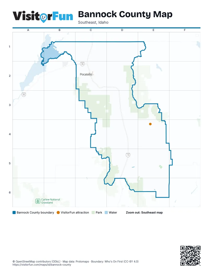
Maps inside Bannock County
2 maps inside, from the street map of Bannock County down.
Street index of Bannock County
Each street on the sheet and the grid squares it crosses.
- Veterans Memorial HighwayC1, C2, D2, D3, D4, D5, D6
- South 5th AvenueC2
- Yellowstone AvenueC1, C2
- South Treaty HighwayC1
- Garrett WayC2
- South 4th AvenueC2
- West Quinn RoadC2
- Pocatello Creek RoadC2
- North Yellowstone HighwayC1
- West Alameda RoadC2
- East Alameda RoadC2
- East Merrill RoadD3
- Pocatello AvenueC2
- Gould StreetC2
- East Gould StreetC2
- North 5th AvenueC2
- YellowstoneC2
- North 4th AvenueC2
- Old US Highway 91C2, D2, D3, D4
- West Portneuf RoadC2, D2
- Philbin RoadC1, C2
- Pole Line RoadC1, C2
- West Pocatello Creek RoadC2
- South Old Oxford HighwayE6
- East Center StreetC2, D5
- North Old Highway 91C2, D2, D3
- Bannock HighwayC2
- North Philbin RoadC1, C2
- North Main StreetC2, D5
- Hawthorne RoadC1, C2
- Woodland RoadD5
- Olympus DriveC1, C2
- West Chubbuck RoadC2
- Hiline RoadC1, C2
- New Day ParkwayC1
- North Hiline RoadC1, C2
- East Price RoadD4
- East Jensen RoadD4
- South Main StreetC2, D5
- North Arthur AvenueC2
- North Fort Hall Mine RoadC2, C3
- Center StreetD3, E4, D5
- East Chubbuck RoadC2
- Northgate ParkwayC1
- East Clark StreetC2
- East Benton StreetC2
- Jefferson AvenueC2
- Oxford HighwayE6
- South Valley RoadC2
- East Ross Fork RoadC1
- East Oak StreetC2
- South Arthur AvenueC2
- State StreetD3, D4
- West Gould StreetC2
- Venture WayC2
- West Benton StreetC2
- Flandro DriveC2
- North Eagle RoadC1
- West Putnam StreetC2
- Madison AvenueC2
- South Oxford HighwayE6
- West Chubbuck Road / North Philbin RoadC2
- Pole Lline RoadC2
- South Marsh Valley RoadD4, D5
- South Marsh Creek RoadD3, D4
- South Mink Creek RoadC3
- Ross Fork Creek RoadD1, D2
- West Buckskin RoadC2, D2
- South Robin RoadD3, D4
- North Rapid Creek RoadD2
- South Dempsey Creek RoadE4
- Blaser RoadE3, E4
- East Virginia RoadD4, E4
- West Reservation RoadB1, C1
- Smith Canyon RoadE4
- West Arimo RoadC4, D4
- South Hawkins RoadC4
- West Hawkins RoadC4, D4
- Ballard RoadB1, C1
- Cemetery RoadB1, C1, D2, E6
- South Hiline RoadC1
- Rio Vista RoadB1, C1
- West Tyhee RoadB1, C1
- East Green Canyon RoadD2, D3
- South Hawthorne RoadC1
- East Smith Canyon RoadD4, E4
- West Siphon RoadB1, C1
- North Rio Vista RoadC1, C2
- South 2nd AvenueC2
- Rattlesnake RoadC4
- Sheep Creek RoadC4
- North Mink Creek RoadC2, C3
- Reservation RoadB1, C1
- West 2 1/2 Mile RoadC1
- East Guidinger RoadD5
- East Arimo RoadD4
- North Marsh Creek RoadD2, D3
- East Hawkins RoadD4
- East Terry StreetC2
- West Gibson Jack RoadC2
- Edmo RoadC1
- North Hawthorne RoadC1
- North Laughran RoadB1
- Satterfield DriveC2
- Barton RoadC2
- McKinley AvenueC2
- Main StreetD2, E4, D5
- South Grant AvenueC2
- East Jackson Creek RoadD2
- Johnny Creek RoadC2
- East Merrick RoadE4
- Meadowview DriveD4
- East Treasure LaneD5
- Henderson RoadD4
- North Hayes AvenueC2
- Harrington RoadC4
- East Maughan RoadE4
- North Inkom RoadD2, D3
- Alvin Ricken DriveC2
- North Front StreetD3, D4
- South Fairway DriveC2
- Country Club DriveC2
- West Eldredge RoadC2
- Gibbs RoadE6
- West Cedar StreetC2
- Foothill BoulevardC2
- East Bonneville StreetC2
- Fairground DriveC2
- Washington AvenueC2, D2
- Monte Vista DriveC2
- North Garfield AvenueC2
- Fairway DriveC2
- Maughan RoadE4
- South Mission RoadC1
- North 1st AvenueC2
- Highland BoulevardC2
- Vista DriveC2
- Butte StreetC2
- Kraft RoadC2
- Swanson RoadB1
- Marsh Valley RoadD4
- East Carter StreetC2
- West Clark StreetC2
- South Front StreetD3, D4
- El Rancho BoulevardC2
- West Fremont StreetC2
- East Poplar StreetC2
- East Maple StreetC2
- Jerome StreetC2
- East Cedar StreetC2
- Hospital WayC2
- Franklin AvenueC2
- West Maple StreetC2
- South 8th AvenueC2
- West Merrill RoadD3
- East Pine StreetC2
- North 8th AvenueC2
- West 11th StreetD3
- East Hayden StreetC2
- South 19th AvenueC2
- West Ross Fork RoadC1
- North 10th AvenueC2
- Nordick CutoffE6
- East Goodenough RoadD4
- Moreland AvenueC2
- Riverside DriveC2
- West Custer StreetC2
- West Center StreetC2
- Memorial DriveC2
- Skyline DriveC2
- North 12th AvenueC2
- Gwen DriveC2
- Knudsen BoulevardC2
- Burley DriveC2
- West Pine StreetC2
- South Hayes AvenueC2
- West Lewis StreetC2
- North Parks RoadC2
- Booth DriveC2
- Grant AvenueD2
- Boarding School LaneC1
- Bannock Road SouthC1
- Batiste RoadC2
- Bullock StreetC2
- Dempsey Creek RoadE4
- South 10th AvenueC2
- West Carson StreetC2
- 4th Avenue WestE4
- East Humbolt StreetC2
- Hurley DriveC2
- Santa Anita AvenueC2
- North 15th AvenueC2
- South Garfield AvenueC2
- Huntington DriveC2
- North Gathe DriveC2
- North 2nd AvenueC2
- South 12th AvenueC2
- Oakwood DriveC2
- Fredregill RoadC2
- Frontage RoadC2
- North Union Pacific AvenueC2
- Martin Luther King Jr WayC2
- Pearl StreetC2
- Evans LaneC2
- North Center StreetE4
- Dairy Creek RoadC4
- East Gunniger RoadD5
- West Jackson Creek RoadD2
- Trail Creek RoadC2
- County RoadD4
- South Union Pacific AvenueC2
- East Quinn RoadC2
- North 19th AvenueC2
- South 15th AvenueC2
- Old Highway 30E3
- Syphon RoadB1
- Mink Creek RoadC3
- Lone Pine RoadE5, E6, F6
- East Grant RoadD5, E5
- South Garden Creek RoadC4
- Cottonwood RoadE5, E6
- Stockton RoadE6, F6
- Road WestD4, E4
- South Cherry Creek RoadD5, D6
- East Sublette RoadD4, E4
- Lundgren RoadD5, D6
- East Arkansas RoadD4
- West Sublette RoadD4
- Thunder Mountain RoadE4
- Mc Daniels RoadD4
- East Richards RoadD5
- South Fork Mink Creek RoadC3
- West Walker Creek RoadC3, D3
- Jeff Cabin RoadD1, E1
- Cunningham RoadD5, E5
- South Raymond RoadD4
- East Old Oregon Trail RoadD4, E4
- South Cambridge RoadD5
- East Harkness Canyon RoadD3
- South Crystal Springs RoadD3, D4
- Ninemile RoadE5
- Marten DriveE4
- East Brush Creek RoadD5, E5
- Redrock RoadE5, E6
- Thacker RoadD4
- South Olson RoadD4, D5
- Baldy Mountain RoadE4
- South RoadE6
- East Inman RoadD2
- West Hoot Owl RoadD2
- Aspen Creek RoadD5
- Jenkins RoadD4
- Deadwood RoadC4
- Hermitsville RoadC4
- Chicken Creek RoadE6
- City Creek RoadC2
- Webb RoadE5
- West Stinger RoadD4
- Scout Mountain Top RoadC3
- Green RoadD3
- Fish Creek RoadE4
- West Armstrong RoadD4
- Salveson RoadD5, E5
- Right Hand RoadE5
- Reese Creek RoadD5
- West McNabb RoadD2
- Gooseberry Creek RoadE6
- South Siler RoadC1
- West Trail Creek RoadC2
- East Lower Rock Creek RoadD3
- Ellis RoadD4
- Fud RoadD1
- Wheeler RoadD1
- South Back Redrock RoadE5, E6
- Sunnyside RoadE3, E4
- South Tool RoadD5
- South Bright RoadE5
- Robber's Roost Canyon RoadD3
- East Nestor RoadD3
- Oxford RoadE6
- Road ME3, C4, E4
- East Ware RoadD5
- South Pratt RoadE5
- North Indian Creek RoadD2, D3
- South Downata RoadE5
- Shrives RoadD5
- Caddy Canyon Access RoadC2, D2
- Selkirk RoadE4
- Big Bear RoadE4
- Sawmill RoadD2
- Clegg Canyon RoadE5
- East Back Downata RoadD5
- Thompson RoadD4, D5
- South Race Track RoadD5
- East Criddle RoadD5, E5
- East Webb Creek RoadD2
- South Newbold RoadE4, D5, E5
- Bonneville RoadD2, D3
- North Harrison AvenueC2
- East Bowman RoadD5
Things to do on the Bannock County map
Places on the map
- American Falls Reservoir
- Arimo
- Bannock County Landfill
- Bartz Field
- Century High School
- Cherry Springs Nature Area
- Chubbuck
- Dempsey Ridge Golf Course
- Downata Hot Springs Campground
- Downey
- Edson Fichter Nature Area
- Fort Hall
- Fort Hall Historic Monument
- Goodenough Creek Campground
- Hawkins Reservoir
- Highland Golf Course
- Idaho State University
- Indian Hills Soccer Complex
- Inkom
- Juniper Hills Country Club
- Lava Hot Springs
- Lava Hot Springs Airport
- Lava Hot Springs KOA
- Lower Ross Park
- Malad Summit Campground
- McCammon
- Mountain View Cemetery
- N.O.P. Park
- Nordic Center
- Park Meadows
- Pebble Creek
- Petticoat Peak Wilderness Study Area
- Pine Ridge Mall
- Pocatello
- Portneuf Medical Center
- Portneuf Wellness Complex
- Riverside Golf Course
- Sacajawea Park
- Scout Mountain Campground
- Swan Lake
© OpenStreetMap contributors, Open Database License, openstreetmap.org/copyright · Map data: Protomaps · Boundary: Who's On First (CC-BY 4.0); Quattroshapes (CC BY 2.0)















