

Idaho road map
I-15 in Idaho map
I-15 is about 194 miles in Idaho. It has 34 exits, from Exit 3 at mile 2 to Exit 190 at mile 189. It meets 11 highways; US 91, US 30 and US 26 meet it in the most grid squares.
Open the map (PDF, US Letter)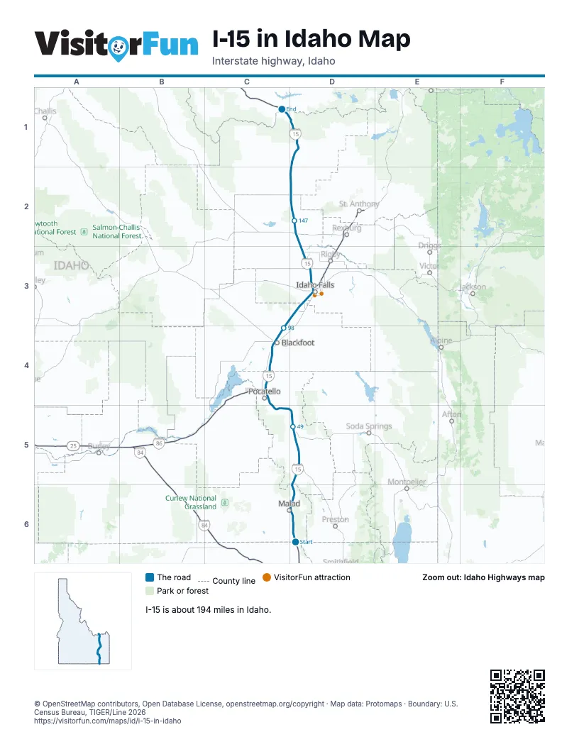
Exits on I-15 in Idaho
Each exit in mile order, with its grid square.
- Exit 3mile 2, D6
- Exit 13mile 13, D6
- Exit 17mile 17, D6
- Exit 22mile 21, D6
- Exit 31mile 30, D5
- Exit 36mile 36, D5
- Exit 40mile 40, D5
- Exit 44mile 44, D5
- Exit 47mile 47, D5
- Exit 57mile 56, D5
- Exit 58mile 58, C5
- Exit 63mile 62, C5
- Exit 67mile 66, C4
- Exit 69mile 68, C4
- Exit 71mile 70, C4
- Exit 72mile 72, C4
- Exit 80mile 79, C4
- Exit 89mile 88, C4
- Exit 93mile 92, C4
- Exit 98mile 97, C4
- Exit 108mile 107, D3
- Exit 113mile 113, D3
- Exit 116mile 115, D3
- Exit 118mile 117, D3
- Exit 119mile 118, D3
- Exit 128mile 126, D3
- Exit 135mile 134, D3
- Exit 143mile 142, D2
- Exit 150mile 149, D2
- Exit 167mile 166, D2
- Exit 172mile 171, D1
- Exit 180mile 179, D1
- Exit 184mile 183, D1
- Exit 190mile 189, D1
Highways I-15 meets
Each highway it meets and the grid squares where they meet.
- ID 38D6
- ID 36D6
- ID 40D5
- US 91C4, C5, D3, D5
- US 30C5, D5
- US 26C4, D3
- US 20D3
- ID 48D3
- ID 33D2
- ID 28D2
- ID 22D2
Towns along I-15 in Idaho
In mile order, with the grid square of each.
- Malad Citymile 13, D6
- Arimomile 39, D5
- McCammonmile 45, D5
- Inkommile 56, D5
- Pocatellomile 63, C5
- Chubbuckmile 71, C4
- Tyheemile 74, C4
- Fort Hallmile 75, C4
- Blackfootmile 90, C4
- Grovelandmile 92, C4
- Idaho Fallsmile 115, D3
- Duboismile 165, D2
- Spencermile 179, D1
Things to do on the I-15 in Idaho map
© OpenStreetMap contributors, Open Database License, openstreetmap.org/copyright · Map data: Protomaps · Boundary: U.S. Census Bureau, TIGER/Line 2026