

Idaho map
Nampa map
About 117,350 people live here (Census Bureau, 2024 estimate). The sheet's index lists 300 streets; Vietnam Veterans Memorial Highway, Caldwell Boulevard and Franklin Boulevard cross the most grid squares. Also on it: Canyon Plaza, Centennial Golf Course and Centennial Learning Campus.
Open the map (PDF, US Letter)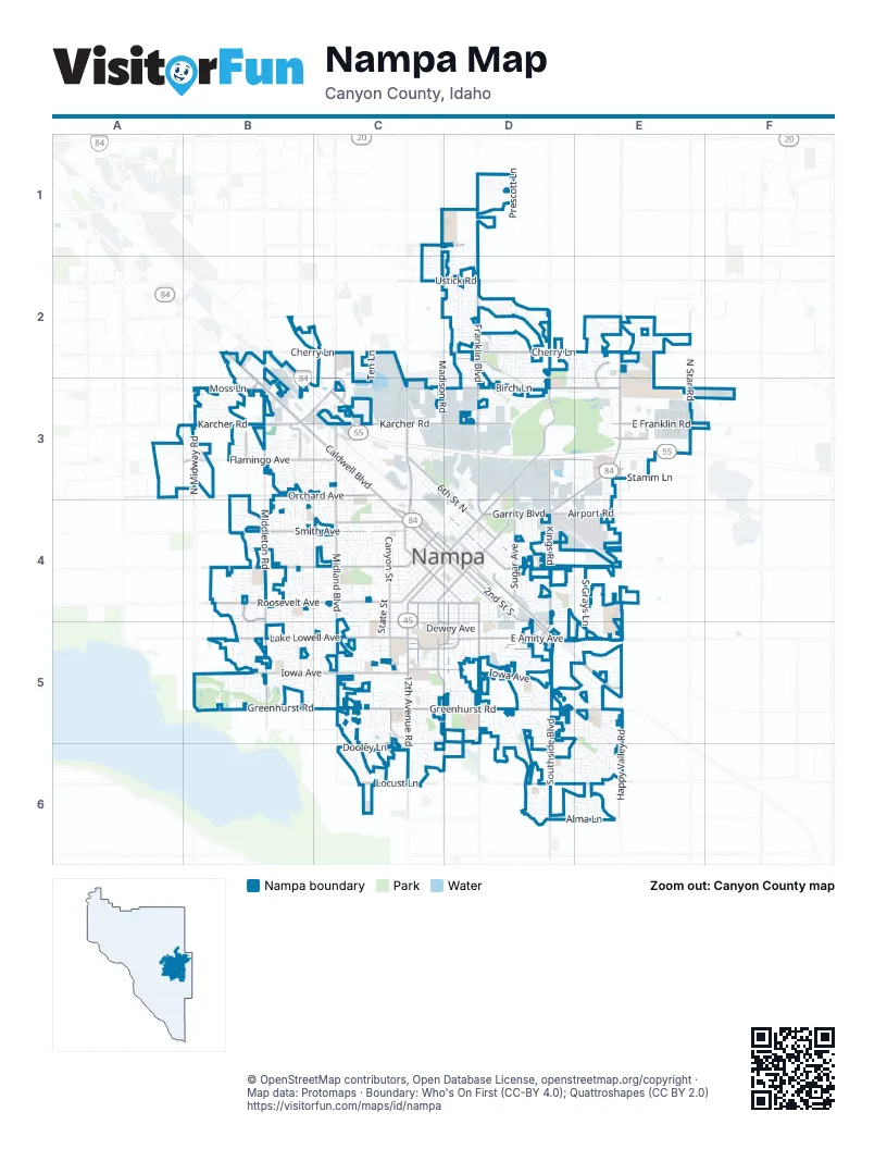
Street index of Nampa
Each street on the sheet and the grid squares it crosses.
- Vietnam Veterans Memorial HighwayB2, B3, C3, D3, E3
- West Karcher RoadB3, C3
- Caldwell BoulevardB2, B3, C3, C4
- 2nd Street SouthC4, D4, D5
- 12th Avenue RoadC4, C5, C6
- Garrity BoulevardD3, E3, D4
- Northside BoulevardC3, C4
- North Midland BoulevardC3, C4
- 3rd Street SouthC4, D4
- Nampa/Caldwell BoulevardB3
- 12th Avenue SouthC4, D4
- 11th Avenue NorthD4
- State Highway 55B3, C3
- Franklin BoulevardD1, D2, D3, D4
- Cherry LaneC2, D2, E2
- East Greenhurst RoadC5, D5, E5
- North Middleton RoadB2, B3, B4
- Lake Lowell AvenueB5, C5
- East Amity AvenueC5, D5, E5
- Lone Star RoadB4, C4
- Southside BoulevardD5, D6
- South Midland BoulevardC4, C5
- South Happy Valley RoadE4, E5, E6
- West Greenhurst RoadB5, C5
- Idaho Center BoulevardE2, E3
- South Middleton RoadB4, B5
- North Kings RoadD3, D4
- East Karcher RoadC3, D3
- East Franklin RoadE3, F3
- South Kings RoadD4, D5
- 7th Street SouthC4, D4
- East Flamingo AvenueD3, E3
- East Colorado AvenueC5, D5
- Ustick RoadC2, D2
- Stamm LaneE3
- North Star RoadE2, E3
- 16th Avenue NorthD4
- South Maple StreetC4, C5
- 16th Avenue SouthC4, D4
- Diamond StreetD4, D5
- North Happy Valley RoadE3
- Northside RoadC3
- North Yale StreetC4
- Midland BoulevardC2, C3
- Can-Ada RoadE2
- 16th Avenue OverpassD4
- 11th Avenue ExtensionD2, D3, D4
- Birch LaneC3, D3, E3
- West Roosevelt AvenueB4, C4
- Smith AvenueB4, C4
- South Canyon StreetC4, C5, C6
- East Railroad StreetD4, D5, E5
- West Flamingo AvenueB3, C3
- Orchard AvenueB3, C3
- West Iowa AvenueB5, C5
- South Powerline RoadD4, D5
- 6th Street NorthC3, D3, D4
- Madison RoadC1, C2, C3
- East Victory RoadD4, E4
- 1st Street SouthC4, D4
- Sunny Ridge RoadC5, D5, D6
- East Locust LaneC6, D6, E6
- North Sugar AvenueD3, D4
- Moss LaneB3
- South Tallapoosa River WayB4, B5
- Iowa AvenueB5
- South Grays LaneE4, E5
- Davis AvenueC4
- North Midway RoadB3
- West Dooley LaneC6
- Airport RoadD4, E4
- East Roosevelt AvenueC4, D4
- East Sheridan AvenueC5, D5
- 11th Avenue SouthC4, D4
- 3rd Street NorthD4
- East Spruce StreetC1, D1
- Holly StreetC4, C5
- East Hawaii AvenueC5, D5
- Fern StreetD4, D5
- East Orah WayD2
- West Locust LaneC6
- 7th Avenue SouthC4
- North Marketplace BoulevardC3
- North Cassia StreetB3
- Linden RoadD1
- North Kensington DriveE2, E3
- East Landry StreetE2
- West Orchard AvenueA3
- East Gate BoulevardE3
- South Sugar AvenueD4
- North Robinson RoadE3
- East Bird AvenueC5, D5
- North Weldstone AvenueB3
- North Amarone AvenueB3
- North Gate BoulevardE3
- South Torana WayB5
- East Power Line RoadD4
- East Sherman AvenueC4, D4
- 10th Avenue SouthC4, D4, C5
- 1st Street NorthC3, C4, D4
- 4th Street SouthC4, D4
- 5th Street NorthC3, D4
- South State StreetC4, C5
- 4th Street NorthC3, D4
- Silvercrest Mobile Home ParkB3
- West Railroad StreetC3
- South Juniper StreetC4, C5, C6
- South Chestnut StreetD4, D5
- 5th Street SouthC4, D4
- East Lincoln AvenueC4, D4
- 6th Street SouthC4, D4
- Blaine AvenueC4
- East Iowa AvenueD5
- Chicago StreetD4, D5
- East Dewey AvenueC5, D5
- Ten LaneC2, C3
- South Florence StreetD4, D5
- East Washington AvenueC4, D4
- Ridgecrest DriveD3, E3
- South Stanford StreetC5, C6
- 2nd Street NorthC4, D4
- Greenhurst RoadB5
- South Elder StreetD4, D5
- Winther BoulevardC4
- 13th Avenue SouthC4, D4
- 8th Street SouthC4, D4
- South Lava Springs LoopD6
- Meadowbrook DriveB5, C5, C6, D6
- 9th Avenue SouthC4, D4
- South Carriage Hill WayB5
- North 39th StreetE3, E4
- North Canyon StreetC4
- East Park Ridge DriveD4, E4
- North Horton StreetC3, C4
- South Taylor StreetD4, D5
- East Comstock AvenueD3, E3
- South Ivy StreetC4, C5
- East Shields DriveD2
- 8th Avenue SouthC4
- South Locust StreetC4, C5
- Alma LaneD6, E6
- 14th Avenue SouthC4, D4
- 15th Avenue SouthC4, D4
- 9th Street SouthC4, D4
- Industrial RoadD3
- West Sheridan AvenueB4, B5, C5
- West Lincoln AvenueB4, C4
- West Pine Manor Mobile Home ParkB3
- 3rd Avenue NorthC3, D3, C4
- Arlington DriveD3
- South Stanley Creek PlaceB4, B5
- Madison AvenueC3, D3
- East Florida AvenueC5, D5
- South Valley DriveC5
- Garland StreetC4, C5, D5
- South Stonehedge DriveD5
- South Bonneville DriveB5
- West Pine Creek DriveB5
- North Armstead AvenueD2
- South Secretariat WayE5
- North Broadmore WayC3
- South Raintree DriveC6
- West Teton AvenueB5, C5
- Flamingo Mobile Home ParkB3, C3
- 10th Street SouthC4
- 10th Avenue NorthD4
- West Buteo DriveB5
- South Nectarine StreetC4, C5
- West Edwards AvenueB5, C5
- East Harbour Grove DriveD5
- South Almond StreetD4, D5
- Karcher Mobile Home ParkB3
- Prescott LaneD1
- North Clearview AvenueE3
- West Dewey AvenueC5
- South Chicago StreetD5
- East Maine AvenueC5, D5
- 18th Avenue SouthD4
- 17th Avenue SouthD4
- Edgebrook DriveD3
- South Avondale AvenueE5, D6
- West Georgia AvenueB5, C5
- North Merchant WayC3
- 7th Avenue NorthD3, D4
- West Kipling WayB4
- 7th Street NorthD4
- Pascoe LaneC5, C6
- North Progress WayE2, E3
- Queens DriveD4, D5
- Arrowhead DriveC4, C5
- Delaware AvenueB4, C4
- East Dooley LaneC6, D6
- Sweetwood CircleC4
- East Man O War DriveE5
- Morning Sun DriveC5
- East Drouillard StreetD2
- Constitution WayC5, D5
- West Roberts AvenueC3, B4, C4
- South Boundary StreetC4, C5
- Sunny LaneC4
- West Belknap DriveB5, C5
- West Blaine AvenueB4, C4
- South Hunters Point DriveB5
- Shoshone AvenueC4
- South Skyview DriveC5, C6
- East Thomas Mill DriveE5, E6
- West Bayhill DriveC5, C6
- Sugar Cane DriveD4
- South Lancaster DriveB4, B5
- South Herron DriveB5
- Sunflower DriveD5
- East Fargo AvenueC3, D3
- Wildflower DriveD5
- Elm LaneD1
- Front StreetD4
- Bay Meadows DriveD3
- North Orchard Heights WayB3, B4
- East Canyon Crossing DriveE2
- East Ohio AvenueD5
- West Brassy Cove LoopB3
- Discovery PlaceD5
- East Jamestown DriveD6, E6
- East Greens DriveD3, E3
- North Brookdale ParkwayD2, D3
- East Toussand DriveD2
- 14th Avenue NorthD4
- East Marble Springs DriveD2
- 12th Avenue NorthD4
- 9th Avenue NorthD4
- East Canterbury LaneD2, D3
- East Dakota AvenueC5, D5
- South Camas StreetB5
- South Horton StreetC5
- Hudson AvenueC4
- Spruce Creek LoopB4, C4
- Norco WayC3
- North 20th StreetD3
- East Path DriveE2
- West Florida AvenueB5, C5
- South Spring Valley DriveB5
- West Arbor Pointe WayC4
- 19th Avenue SouthD4
- North Gentry DriveE2, E3
- East Brooklyn DriveE5
- East Maryland AvenueC5, D5
- West Hawaii AvenueB5, C5
- 4th Avenue NorthD3, C4
- East Terra Linda WayE3
- South Walnut Ridge WayE6
- West Aberdeen AvenueB5, C5
- 11th Street SouthC4
- Goldenrod DriveD5
- South Miller WayB5
- North Elder StreetD3
- High StreetC4
- South Blue Heron WayE4, E5
- Lyons DriveC4
- West Mission Pointe DriveB4
- South Middle Creek DriveC4, C5
- East Lekeitio Village DriveE2
- West Radcliff StreetB4
- West Havenwood AvenueB4
- South Sandcrest WayC5
- East Plaza LoopD3
- South Fern StreetD5
- B StreetB3
- South Olive StreetC4, C5
- 18th Avenue NorthD4
- 17th Avenue NorthD4
- Treasure Valley WayE3
- Port StreetD4
- South Oak Ridge AvenueE6
- 6th Avenue SouthC4
- South Royal Meadows DriveE5
- West Washington AvenueB4, C4
- West Kinghorn DriveC4
- 20th Avenue SouthD4
- Buckskin DriveD4, E4
- South Baroque AvenueB4
- West Heather Woods DriveC4
- Owyhee AvenueC4
- South Rosa Parks WayE6
- 13th Avenue NorthD4
- North Treeline AvenueD1, D2
- North Yorkshire LaneD2, D3
- Meadowview DriveC4
- South Bluegrass DriveD5, E5
- West Bodie River LoopB4
- West Sherman AvenueC4, B5, C5
- 15th Avenue NorthD4
- North Sherwood DriveC4
- War Eagle WayC5
- West Shoshone AvenueB4, C4
- East Sunrise Rim RoadC6
- North Zion Park DriveB4, C4
- North Midsummers LaneD2
- South Beechwood DriveC4
- West Aldbury AvenueB4
- East Colter Bay DriveD2
- West Hawkins AvenueB3
Places on the map
- Canyon Plaza
- Centennial Golf Course
- Centennial Learning Campus
- Center Point RV Park
- Central Elementary School
- College of Western Idaho
- Columbia High School
- Corwin Ford Nampa
- Crossroads Plaza
- East Valley Middle School
- Endeavor Elementary School
- Estafeta
- Fall River Park
- Ford Idaho Center Amphitheater
- Ford Idaho Center Horse Park
- Fred Meyer
- Holly Plaza
- Idaho Arts Charter School
- Iowa Elementary School
- Johnson Square
- Kohlerlawn Cemetery
- Lake Ridge Elementary School
- Lakeview Park
- Liberty Park
- Lions Park
- Lone Star Middle School
- Maple Grove Park
- Nampa Gateway Center
- Nampa High School
- Nampa Municipal Airport
- Orah Brandt Park
- Osborne Park
- RedHawk Golf Course
- Ridgecrest Golf Club
- Ridgevue High School
- Saint Alphonsus Medical Center
- Saint Alphonsus Medical Center - Nampa
- State Hospital West
- Treasure Valley Market Place
- West Park
© OpenStreetMap contributors, Open Database License, openstreetmap.org/copyright · Map data: Protomaps · Boundary: Who's On First (CC-BY 4.0); Quattroshapes (CC BY 2.0)