

Idaho map
Shoshone County map
About 14,074 people live here (Census Bureau, 2024 estimate). The sheet's index lists 300 streets; Saint Joe River Road, Coeur d'Alene River Road and Silver Valley Road cross the most grid squares. Things to do inside the boundary: Route of the Hiawatha, Lookout Pass Ski Area and Silver Mountain Resort.
Open the map (PDF, US Letter)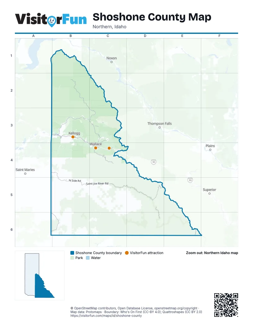
Street index of Shoshone County
Each street on the sheet and the grid squares it crosses.
- Burke RoadC4
- 5th StreetB3, C4
- Bank StreetC4
- Front StreetC4
- The Harry F. Magnuson WayC4
- Coeur d'Alene River RoadB2, B3, C3
- State Highway 3A6, B6
- Silver Valley RoadB3, B4, C4
- Burke-Canyon Creek RoadC3, C4
- Main StreetB3, B5
- McKinley AvenueB3
- West Yellowstone AvenueB3, C4
- East Mullan AvenueB3, B4, C4
- North Frontage RoadC4
- South Frontage RoadC4
- Friday AvenueC4
- West Cameron AvenueB3
- Bunker AvenueB3
- Mullan AvenueB3, B4, C4
- River StreetC4
- Prichard Creek RoadC3
- East Cameron AvenueB3
- Markwell AvenueC4
- Atlas RoadC4
- North 3rd StreetB3
- West McKinley RoadB3
- Highway 3 SouthA6
- South Johnson StreetB3
- State Highway 4C3
- Saint Joe River RoadA4, B4, B5, C5, D5, D6
- Moon Pass RoadC4
- Gold Creek RoadD5, E5
- Beaver Creek RoadC3
- National Forest Development Road 456C3
- Pierce - Superior RoadE6
- Riverview DriveA3, B3
- Nine Mile Creek RoadC3, C4
- Benthams RoadC4
- South Division StreetB3
- Old Highway 10B3
- 3rd StreetB3, C4
- North Division StreetB3
- Cedar StreetB3, C4, B6
- 1st StreetB3, C4, B5
- North Hill StreetB3
- 7th StreetB3, C4
- Mill RoadB3, C4
- 6th StreetB3, C4
- Hunter StreetC4
- High StreetC4
- King StreetC4
- Little North Fork RoadB3
- Park RoadB3
- Hilltop OverpassB3
- East Canyon RoadA3
- Hill Top OverpassB3
- National Forest Development Road 391D4, D5, E5
- Avery - Timber Creek Road 201C5, D5, D6
- Saint Joe National Forest Road 301C5, B6, C6
- National Forest Development Road 400B2, B3
- Falls Creek RoadC2, B4
- National Forest Development Road 260A2, B2, B3
- Old River RoadB3
- Shoshone Creek RoadB2, C2, C3
- Homestead Creek RoadB5, C5
- National Forest Development Road 409B2, B3
- Adair Creek Road 1268C5, C6
- National Forest Development Road 802B2
- National Forest Development Road 424B3, C3
- Prospector Creek Road 752C5, D5
- Mica Creek RoadB5
- Lost Creek RoadC2, C3
- Glover Creek RoadB6, C6
- Graves Creek Road 764B6
- Fishhook Creek Road 301C5
- National Forest Development Road 796B2, A3, B3
- Big Creek RoadB3, B4, B5
- Marble Creek RoadB5
- National Forest Development Road 943B2, B3
- National Forest Development Road 3099B1, B2
- Evergreen Ridge RoadA5, B5
- Oregon-Toboggan RoadC3
- National Forest Development Road 1999B5, C5
- Blackwell Divide Road 226B5
- Gold Ridge RoadB4, A5, B5
- West Fork Montana Creek Road 1259C5, C6
- Potlatch RoadB5
- Fuzzy Bennett RoadD5
- Avery - Timber Creek RoadD5, D6
- Trout Creek RoadB4, B5
- Huckleberry Mountain RoadB5
- National Forest Development Road 306B1
- North Side RoadB5
- Clark Fork-Coeur d'Alene Divide RoadC2, C3
- National Forest Development Road 620B3
- National Forest Development Road 205A1, B1
- National Forest Development Road 1956D5
- Loop Creek Road 326C4, D4
- Eagle Creek Road 758B5
- Hobo Pass RoadB5, B6
- Hoodoo Little North Fork Road 1258C5, D5, C6
- National Forest Development Road 622B3
- Cornwall Creek RoadB5
- National Forest Development Road 332A1, B1
- National Forest Development Road 225C4, C5
- Childs Creek RoadB5, B6
- Nfs Road 947C2
- Moon Pass Road / North Fork Saint Joe River RoadC4, C5
- National Forest Development Road 412B1, B2
- Crooked Ridge Road 1278E5
- West Fork Merry Creek Road 1491B5, B6
- Boulder Creek Road 396B5, C5
- National Forest Development Road 959B2
- Merry Creek RoadB5, B6
- National Forest Development Road 422A2, B2
- Outlaw Creek Road 1928C5
- Blackwell Hump Divide RoadA5, B5
- Gold Center Road 301C6
- Bobtail Cutoff RoadC3
- National Forest Development Road 335B2, B3
- Saint Joe National Forest Road 1914B5
- National Forest Development Road 339D5
- USFS Road 946B3
- National Forest Development Road 994B2, B3
- Siberts Old River RoadC5
- National Forest Development Road 1569B2
- National Forest Development Road 1988C5, D5
- National Forest Development Road 1215B4, B5
- National Forest Development Road 900B2
- Tepee Creek RoadB2
- USFS Road 424B3, C3
- National Forest Development Road 330B3, B4
- Indian Dip Road 220C6
- National Forest Development Road 1907B4, B5
- National Forest Development Road 513B2
- USFS Road 338D5
- Spion Kop RoadB2
- National Forest Development Road 966B3
- National Forest Development Road 207B2, B3
- Olson Creek RoadB5
- East Fork Pine Creek RoadB4
- National Forest Development Road 204B5
- Jack Waite Forks RoadC3
- Quartz Creek Road 339D5
- USFS Road 720C5, C6
- National Forest Development Road 746B4, B5
- Middle Dam Creek RoadC2
- Daveggio Knob RoadB5, C5
- National Forest Development Road 1219D5, E5
- National Forest Development Road 3723D5
- West Eagle RoadC3
- Hoyt Mountain Road 325C5
- Old State Highway 4C3
- Sierra NevadaB3, B4
- Saint Maries River Road 382B6
- National Forest Development Road 961B3
- Daveggio Creek RoadB5
- National Forest Development Road 338D4, D5
- National Forest Development Road 2352B3
- National Forest Development Road 457C6
- Falls Creek Power Line RoadC2
- Twin Creek RoadC5
- Hulliman Creek RoadC2
- Indian Dip Road 457C6
- USFS 1464C5, D5
- National Forest Development Road 507C4
- National Forest Development Road 257B3
- National Forest Development Road 361B6
- National Forest Development Road 259A3, B3
- National Forest Development Road 6749B2
- Old Yellowstone TrailC4, D4
- National Forest Development Road 323A3, B3
- National Forest Development Road 480B5, C5
- USFS 490B5
- Rutlrdge Creek Road 761C5, C6
- National Forest Development Road 209A3, B3
- National Forest Development Road 1451B6
- National Forest Development Road 326D4
- Saint Joe National Forest Road 509D5
- Upper Tourist RoadB2
- Cooper Pass RoadC3
- National Forest Development Road 271C3
- East Eagle RoadC3
- Fire RoadB3
- National Forest Development Road 534A2, B2
- Clee Creek-Bloom Peak RoadC2, C3
- French Gulch RoadB3, B4
- East CCC RoadA3, B3
- National Forest Development Road 903A1, B1
- National Forest Development Road 509D5
- USFS 1272C5, C6
- West Fork Pine Creek RoadA4, B4
- Stwash Peak RoadC5
- National Forest Development Road 407A2, B2
- National Forest Development Road 2329B2
- East Fork Gold Creek Road 1222D5
- Buzzard Roost Road 363C6
- National Forest Development Road 1244C5
- National Forest Development Road 447A6
- Little Guard Peak RoadB2, C2, C3
- Saint Joe River Road 218D5
- National Forest Development Road 1227D5
- National Forest Development Road 957B3
- National Forest Development Road 1533B1
- Little Haystack Mountain RoadC2
- Hugus Creek RoadB5
- Kelley Creek RoadC5
- Bonnieville Power Rd 333B5
- Snow Creek RoadB1
- National Forest Development Road 3096B1
- National Forest Development Road 1231D5
- Middle Sister Road 324C5, D5
- Ross Gulch RoadB4
- Tepee Creek Road 812B2
- National Forest Development Road 1214D5
- Saint Joe National Forest Road 217C5
- Saint Joe National Forest Road 1486B6
- National Forest Development Road 1497B5
- Sisters Creek Road 1245C5
- Lick Creek Road 753C5
- Freezeout Mountain RoadB6, C6
- Saint Joe National Forest Road 201C5
- National Forest Development Road 3092B1
- Bechtel Mountain RoadA6, B6
- Jungle Creek Road 1987C5
- National Forest Development Road 602B2, C2
- National Forest Development Road 1211C5
- USFS Road 965B3
- National Forest Development Road 930B3
- USFS 1258D5
- Bear Creek RoadC3
- National Forest Development RoadB1, B3, C3
- National Forest Development Road 991B2, B3
- Idaho Point Road 992B1, B2
- National Forest Development Road 348B4
- South Falls Creek Cutoff RoadC2
- National Forest Development Road 765A6, B6
- Evergreen RoadB5
- Buzzard Roost RoadC6
- East Eagle Creek RoadC3
- Old Milwaukee Road RR GradeB4
- Omaha Creek Road 2352B3
- USFS Road 1005B3
- Kelley Creek Road 1237C5
- Pipe Creek RoadC2
- National Forest Development Road 1586B3, C3
- Montgomery Gulch RoadB3
- Delta Murray RoadC3
- National Forest Development Road 2361B3
- Saint Joe National Forest Development 1469 RoadB5
- Sisters Creek Road 288C5
- Red Raven Creek Road 1928C5
- USFS 1925C5
- National Forest Development Road 956B2
- Kings Pass RoadC3
- Nfs Road 948B2, C2
- Mica Creek Road 1900B5
- Larson RoadC4
- Saint Joe National Forest Road 475B6
- Carbon Center RoadC3
- Bussel Peak RoadB5
- Haystack Road 945C2
- Saint Joe National Forest Road 216C5
- Pine Creek RoadB3, B4
- Cranberry Creek Road 1254B5
- West Moon Gulch RoadB3
- Camp 40 RoadB6
- Roundtop L O RoadC5
- National Forest Development Road 1457B4
- Sisters Creek RoadC5
- National Forest Development Road 504B6
- USFS 1504B2, C2
- Trapper Creek RoadB4
- Bond Creek RoadA4, B4
- Marble Mountain RoadB5
- Red Raven Creek 1287C5
- Hoyt Mountain Road 1926C5
- National Forest Development Road 214D5
- Hemlock Mountain Road 796A2, B2, A3
- Bird Creek Road 338D5
- National Forest Development Road 3321B6
- National Forest Development Road 482B3
- South Fork Falls Creek RoadC2
- National Forest Development Road 1905B6
- USFS Road 2352B3
- National Forest Development Road 389C4
- USFS 3332B5
- Clark Fork Road 1533B1
- National Forest Development Road 2376B4
- National Forest Development Road 2322C3
- Moon Pass Road 456C4
- USFS Road 506C4
- Tepee Summit RoadA2, B2
- National Forest Development Road3332B5
- Siwash Peak RoadC5
- Two Mile RoadB3, C3
- National Forest Development Road 993B2
- National Forest Development Road 409AB2
- National Forest Development Road 911A2, B2
- National Forest Development Road 453A4, B4
Things to do on the Shoshone County map
Places on the map
- Bumblebee Campground
- Bunker Hill Central Impoundment Area
- Elsie Lake
- Fawn Lake
- Five Lakes Butte Research Natural Area
- Fortynine Meadows Research Natural Area
- Galena Ridge Golf Course
- Grandmother Mountain Wilderness Study Area
- Halo Lake
- Heart Lake
- Hobo Cedar Grove Botanical Area
- Kellogg
- Lost Creek Dispersed Campground
- Lost Lake
- Lower Glidden Lake
- Lower Stevens Lake
- Lund Creek Research Natural Area
- Mullan
- Osburn
- Pinehurst
- Pinehurst Golf Course
- Pond Peak Research Natural Area
- Revett Lake
- Saint Joe Lake
- Saint Joe Wild and Scenic River
- Shoshone Country Club
- Shoshone County Airport
- Silver Mountain Resort
- Skyland Lake
- Smelterville
- Snow Peak Wildlife Management Area
- Spion Kop Research Natural Area
- Theriault Lake Research Natural Area
- United Cemetery
- Upper Fishhook Research Natural Area
- Upper Glidden Lake
- Upper Shoshone Creek Research Natural Area
- Upper Stevens Lake
- Wallace
- Wardner
Next to Shoshone County
- Noxon
- Plains
- Saint Maries
- Superior
- Thompson Falls
© OpenStreetMap contributors, Open Database License, openstreetmap.org/copyright · Map data: Protomaps · Boundary: Who's On First (CC-BY 4.0); Quattroshapes (CC BY 2.0)















