

Idaho map
Twin Falls map
About 55,589 people live here (Census Bureau, 2024 estimate). The sheet's index lists 300 streets; 9th Avenue East, Fillmore Street and Locust Street North cross the most grid squares. Things to do inside the boundary: Magic Valley Mall.
Open the map (PDF, US Letter)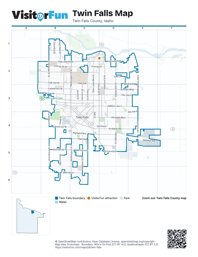
Street index of Twin Falls
Each street on the sheet and the grid squares it crosses.
- Pole Line Road WestA2, B2, C2
- Washington Street NorthC1, C2, C3
- Blue Lakes Boulevard NorthC2, C3
- Kimberly RoadC4, D4, E4
- 2nd Avenue EastC4, D4
- Addison AvenueC3
- Blue Lakes BoulevardC3, C4
- 2nd Avenue WestB3, C3, C4
- Addison Avenue WestB3, C3
- Shoshone Street EastC3, C4
- 2nd Avenue SouthC4
- 2nd Avenue NorthC3, C4
- Washington StreetC3, C4
- North 3000 East RoadC1, D1, C2
- Shoshone Street SouthC4
- Oregon National Historic TrailD1
- Eastland Drive NorthD2, D3, D4
- Washington Street SouthC4, C5, C6
- Addison Avenue EastC3, D3, E3
- Falls Avenue EastC2, D2, E2
- Cheney Drive WestA2, B2, C2
- Falls Avenue WestB2, C2
- Orchard Drive EastC5, D5
- East 3600 NorthB6, C6
- Cheney DriveC2, D2
- North 3100 EastD4, D5
- Pole Line Road EastC2, D2
- Falls AvenueC2
- North College RoadC2
- Bridgeview BoulevardD1, D2
- Orchard DriveC5
- Orchard Drive WestB5, C5
- Eastland DriveD4
- Blue Lakes Boulevard SouthC4, C5
- 6th Avenue WestC4
- Fillmore StreetC1, D1, C2, C3
- Grandview Drive NorthB1, B2, B3
- Park View DriveB1, B2
- Elizabeth BoulevardC4, D4, E4
- Harrison Street SouthC4, C5, C6
- Locust Street NorthC2, D2, C3, D3
- Stadium BoulevardC3, D3, E3
- Filer Avenue EastC3, D3, E3
- Madrona Street NorthD2, D3
- North College Road WestA2, B2, C2
- Filer Avenue WestA3, B3, C3
- Hankins RoadE3, E4, E5
- Caswell Avenue WestA3, B3, C3
- Harrison StreetC1, C2, C3
- Park AvenueC4, C5
- Locust StreetD3, C4, D4
- Shoup AvenueC3
- Heyburn AvenueC3
- Filer AvenueC3
- South Park Avenue WestB4, C4
- Blake Street NorthB2, B3
- Highland Avenue EastC4, D4
- Federation RoadB1
- Sparks Street NorthB2, B3
- Carriage Lane NorthD3
- Heyburn Avenue EastC3, D3
- Locust Street SouthC4, D4, C5, D5
- Morningside DriveD3, D4
- Hankins Road NorthE2, E3
- Minidoka AvenueC4
- Shoup Avenue WestB3, C3
- Main Avenue NorthC3, C4
- Main Avenue EastC4
- Grandview DriveB3, B4
- Heyburn Avenue WestB3, C3
- Osterloh AvenueD5
- Maurice StreetD3, D4
- Madrona StreetD4
- Fairfield Street NorthC3, C4
- Idaho Street EastC3, C4
- North 3300 EastF4, F5
- Rose StreetB4
- Maurice Street NorthD3
- Canyon Rim RoadB1
- Martin StreetB3
- Fairfield Street WestC4
- Victory AvenueB4, C4
- Caswell AvenueC3
- Canyon Springs RoadC1, C2
- Madrona Street SouthD4, D5
- South Park AvenueC4
- Idaho Street SouthC4
- North College Road EastC2, D2
- Harmon Park AvenueD4
- Morrison StreetB3
- 4th Avenue EastC4, D4, E4
- Eldridge AvenueC5, D5, E5, F5
- 9th Avenue EastC3, D3, E3, D4, E4
- Julie LaneC2, D2
- Mountain View DriveD2, D3
- Wendell StreetB2, B3
- Crestview DriveA2, B2, C2
- Elm Street NorthC2, C3
- 3rd Avenue EastC4, D4
- Quincy StreetC2, C3
- Monroe StreetC2, C3
- Whispering Pine DriveD3, E3
- Canyon Crest Drive WestB1, C1
- Sunrise Boulevard NorthD2, D3
- Ridgeway DriveB2, C2
- Field Stream WayB2, B3
- Robbins AvenueB3, C3
- Kenyon RoadB5, B6
- Trotter DriveD3, E3, E4
- Bitterroot DriveC2, D2
- Cheney Drive EastD2
- Buckingham DriveD3
- Carriage LaneD3, D4
- Meadowview LaneE3, E4
- 3rd Avenue WestB3, C3, C4
- Borah Avenue WestB3, C3
- Alturas Drive NorthD3
- Jackson StreetC3
- Longbow DriveD3, E3
- Buchanan StreetC3
- Candleridge DriveD2
- Valencia StreetC5, C6
- Polk StreetC3
- 11th Avenue EastC3, D3
- Adams StreetC3
- Ash StreetC3, C4
- 4th Avenue WestB4, C4
- Galena DriveD2
- Meadowview Lane NorthE2, E3
- Highland AvenueC4
- 8th Avenue EastC3, C4, D4
- Columbia DriveB1
- Elm StreetC3, C4
- Wirsching Avenue WestA3, B3, C3
- Pierce StreetC3
- 7th Avenue EastC3, C4, D4
- Hansen Street EastC3, C4
- Cypress WayD3, D4
- Madison StreetC3
- Jefferson StreetC3
- Grandview Drive SouthB5, B6
- Railroad AvenueB4, C4
- Sunray LoopE3
- 6th Avenue EastC4, D4
- Clinton DriveC5
- Canyon Crest DriveC1, C2
- Rose Street NorthB2, B3
- Golden Pheasant DriveB5
- 5th Avenue EastC4, D4
- Gooding Street NorthC3, C4
- Canyon Trail WayB1, B2
- Frontier RoadC2
- Bracken Street NorthB2, B3
- Beryl AvenueD5
- Starlight LoopA2, B2
- Clear Creek LoopD2
- Blake Street SouthB2, B3, B4
- Maple AvenueC3, D3
- Taylor StreetC3
- North Pointe DriveB2
- White Birch AvenueA2, B2
- Hillcrest DriveD3
- Diamond AvenueC4
- 4th Avenue NorthC3, C4
- Van Buren StreetC3
- Borah AvenueC3
- 5th Avenue WestB4, C4
- Paintbrush DriveD4, E4
- Floral AvenueD4
- Pheasant Road WestB5, C5
- El Camino AvenueC5
- 3rd Avenue NorthC3, C4
- Morning Sun DriveE3
- Warren AvenueD5
- Meadows LaneC3
- Park Meadows DriveB2
- Atlantic StreetB4, B5, B6
- Walnut StreetC3, C4
- Creekside WayA2, A3
- Evergreen DriveC2, D2
- Targhee DriveC2, D2
- Gardner AvenueC4
- Pheasant RoadC5
- Poplar AvenueC3, D3
- Shoup Avenue EastC3, D3
- Sunnybrook AvenueA2, B2
- Carriage WayD3, E3
- Aspenwood LaneD3, D4
- Settlers Ridge TrailB1
- Hailee AvenueC5
- Parkwood DriveC4, C5
- Tyler StreetC3
- Eden Street NorthC3, C4
- Jerome Street EastC4
- Sunrise BoulevardD3, D4
- Southwood AvenueB6, C6
- Shade Tree TrailB1
- Larkspur DriveD3
- Northern Pine DriveB2
- Juniper Street NorthD2, D3
- Joshua WayD3, E3
- Aspenwood DriveD4
- Dover LaneD4
- Jayco AvenueE5, F5
- Arrow Wood CourtB3
- Grange LaneD4, D5
- Fawnbrook CourtC2
- Frank Henry RoadA2, B2
- Del Mar DriveD3, D4
- Dubois Avenue WestB3, C3
- Blick LaneB1
- Parkway DriveB2
- Lois StreetC4
- Terra AvenueA2, B2
- Twin Parks DriveB2
- Oleary WayD3, D4
- Lincoln Street NorthC2
- North Fork RoadB1
- Gooding Street WestC4
- Sherry LaneD4
- Wright AvenueD4
- North Haven DriveB2
- Silver Creek WayB2
- Gage AvenueC6
- 6th Avenue NorthC3, C4
- Falling Leaf LaneB1
- Wiseman AvenueB3, C3
- Sommer StreetB5, B6
- Greentree WayD3, D4
- Sagebrush DriveD4, E4
- Commercial AvenueC4
- Russet StreetB4
- Sundance DriveE3
- Ketchum Street EastC4
- 5th Avenue NorthC3
- Birchton LoopB2
- Diekes Street NorthC3, C4
- Southwood Avenue WestB6
- Lincoln StreetC3
- Kenbrook LoopB2
- 3rd Avenue SouthC4
- Market AvenueB4
- Noble StreetC4, C5
- Diamond Avenue WestB4, C4
- Sherry DriveD4
- Settlers LaneB1
- Ash Street NorthC3
- Canyon StreetC4
- Villa RoadB5
- Eden Street WestC4
- Dierkes Street WestC4
- Avenida del Rio DriveC2
- Sunshine DriveE3
- IB Perrine RoadB1
- Northstar AvenueB2, C2
- Willowa RoadB1
- Monaco StreetB2
- Rimview DriveD3
- Tamarack LoopD2
- Canyon Park AvenueC1
- 7th Avenue NorthC3
- Vista DriveC6
- Ostrander Street NorthB3
- Rivercrest CircleC1, C2
- 4th Avenue SouthC4
- Welch LaneB4
- Starfire StreetB2
- Eastgate DriveD4, E4
- Chuckwagon PlaceD3
- Lawndale DriveC2, D2
- Sunburst StreetB2
- Park Terrace DriveB2
- Oak StreetB3, B4
- Magic RoadA2, B2
- Knottingham DriveD3
- Talus LoopB1
- Hometowne RoadB1
- Wakefield StreetD4
- Northern Sky DriveB1
- Bradley StreetB2
- Gregory WayC5
- Hidden Trail LaneB1
- Liberty Street EastC4
- Plain View DriveD2
- Castleford Street NorthC3
- Clearwater WayD2
- Lawrence AvenueB2
- Lynwood BoulevardC3
- Pioneer PathB1
- Castleford Street WestC3, C4
- Traveler's WayB1
- Walnut Street NorthC2, C3
- Tendoy StreetB1
- Lacasa LoopC5
- Pomerelle DriveD2
- Sidney StreetC4
- Mae DriveD4
- Meadowlark WayE4
- Pahsimeroi DriveD2
- Green Acres DriveC2
Things to do on the Twin Falls map
Places on the map
- Airport Road Freewill Baptist Church
- Albertsons
- Amazing Grace Fellowship
- Applebee's
- Ascension Park
- Asian Food Market
- Baxter's Park
- Best Western Plus Twin Falls
- Bethel Temple
- Bible Missionary Church
- Bridgeview Estates
- Canyon Ridge High School
- Chamber of Commerce
- City Park
- Clyde Thomsen Park
- College of Southern Idaho
- Fred Meyer
- Frontier Field
- Harmon Park
- Lincoln Elementary School
- Lowe's
- Magic Valley Mall
- Oregon Trail Elementary
- Oregon Trail Youth Complex
- Perrine Elementary School
- Sawtooth Elementary School
- South Hills Middle School
- St. Luke’s Canyon View Behavioral Health Services
- Sunset Memorial Park
- The Cage
- Twin Falls Cemetery
- Twin Falls City Hall
- Twin Falls City Park Historic District
- Twin Falls Golf Club
- Twin Falls High School
- Twin Falls historic districts
- Twin Falls Original Townsite Residential Historic District
- Twin Falls Warehouse Historic District
- Walmart Supercenter
- Xavier Charter School
© OpenStreetMap contributors, Open Database License, openstreetmap.org/copyright · Map data: Protomaps · Boundary: Who's On First (CC-BY 4.0); Quattroshapes (CC BY 2.0)















