

Idaho map
Twin Falls County map
About 96,509 people live here (Census Bureau, 2024 estimate). The sheet's index lists 300 streets; Spring Road, East 3800 North and East 3600 North cross the most grid squares. Things to do inside the boundary: Magic Valley Mall, Perrine Bridge and Shoshone Falls.
Open the map (PDF, US Letter)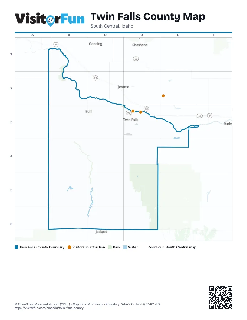
Street index of Twin Falls County
Each street on the sheet and the grid squares it crosses.
- East 3800 NorthB3, C3, D3, E3
- 2400 EastC3, C4, C5
- California National Historic TrailC5, C6
- Highway 30B2, B3
- North 1500 EastC2, C3
- North 3500 EastD3, D4
- 4100 NorthC3, D3
- North 1500 East RoadC2, C3, C4
- East 4100 NorthB3, C3
- Kimberly RoadD3
- Pole Line Road WestD3
- Washington Street NorthD3
- 3900 NorthC3
- North 950 EastB2, B3
- Addison Avenue WestC3, D3
- Blue Lakes Boulevard NorthD3
- North 3000 East RoadD3, D4
- 2nd Avenue EastD3
- Burley AvenueB3, C3
- Addison AvenueD3
- Blue Lakes BoulevardD3
- 2nd Avenue WestD3
- Broadway Avenue NorthB3, C3
- Washington StreetD3
- Shoshone Street EastD3
- 2nd Avenue SouthD3
- 2nd Avenue NorthD3
- Shoshone Street SouthD3
- Broadway Avenue SouthC3
- Main Street NorthD3
- Oregon National Historic TrailD3
- Sawtooth BoulevardB3, D3
- Hansen BridgeD3
- Clear Lakes RoadC2
- East 3600 NorthB3, C3, D3, E3
- East 3200 NorthB3, C3, D3, E3
- East 4000 NorthA3, B3, C3, D3
- East 3700 NorthB3, C3, D3, E3
- East 2900 NorthB4, C4, D4
- North 1400 EastB2, C2, B3, C3
- North 900 EastB2, B3, B4
- Rock Creek RoadD3, D4, D5
- North 3800 EastD3, D4
- Lily Grade RoadB3, B4
- North 2700 EastD3, D4
- North 3000 EastD3, D4
- North 4500 EastE3, E4
- North 3100 EastD3, D4
- 2700 EastD4, D5
- East 2400 NorthB4, C4, D4
- Addison Avenue EastD3
- Orchard Drive WestC3, D3
- East 3900 North RoadD3
- East 2600 NorthD4
- Blue Lakes Boulevard SouthD3
- East 2800 North RoadB4, D4
- Main StreetB3, C3, D3
- Eastland Drive NorthD3
- Washington Street SouthD3
- Falls Avenue EastD3
- North 4475 EastE3, E4
- Falls Avenue WestD3
- 3000 NorthD3
- Cheney Drive WestD3
- Pole Line Road EastD3
- Orchard Drive EastD3
- Cheney DriveC3, D3
- North 4525 EastE3, E4
- Orchard DriveC2, D3
- North College RoadD3
- Sawtooth AvenueB3, C3
- Fruitland AvenueB3
- Falls AvenueD3
- Main Street SouthD3
- Bridgeview BoulevardD3
- Center Street EastD3
- Eastland DriveD3
- Center Street WestD3
- Boyd Street WestE3
- 6th Avenue WestD3
- Three Creek RoadA5, B5, C5
- North 1900 EastC2, C3, C4
- House Creek RoadB4, A5, B5
- East 3500 North RoadB3, C3
- East 3000 NorthC4, D4, E4
- East 4300 NorthB3, C3
- North 2300 Road EastC3, C4
- Antelope Spring Roseworth RoadB4, B5
- North 700 EastB2, B3, B4
- North 1000 EastB2, B3
- East 4400 NorthB2, C2
- North 1700 EastC2, C3
- North 3600 EastD3, D4
- East 2500 NorthC4, D4
- River RoadB2, C2
- North 3300 EastD3
- 400 East RoadB1, B2, B3
- North 600 EastB2, B3, B4
- Spring RoadB2, C2, C3, D4, D5
- North 2000 EastC2, C3, C4
- North 3400 EastD3
- 800 South RoadE4
- East 3425 NorthC3, E3
- North 2300 EastC2, C3, C4, C5
- East 3900 NorthB3, C3
- Balanced Rock RoadA3, B3
- North 3700 EastD3
- North 2500 East RoadC3
- East 2200 NorthC4
- North 4900 EastE3, E4
- 1520 North RoadC5
- 4700 North RoadB2
- North 2400 EastC2, C3
- Castleford Glenns Ferry RoadB2, B3
- East 1700 NorthC5, D5
- North 2250 EastC3
- North 400 EastB2, B3
- South Park Avenue WestC3, D3
- 2300 EastC3, C5
- Hankins RoadD3
- East 2500 North RoadB4
- Grandview Drive NorthD3
- Fillmore StreetD3
- Park View DriveD3
- Harrison Street SouthD3
- 800 East RoadB2, B4
- Airport RoadD3
- Filer Avenue EastD3
- Elizabeth BoulevardD3
- Canyon Springs RoadD3
- Stevens AvenueC3
- North Western AvenueC4
- Locust Street NorthD3
- Stadium BoulevardD3
- North College Road WestD3
- Locust StreetC3, D3
- 2900 North RoadD4, E4
- Hankins Road NorthD3
- Madrona Street NorthD3
- Harrison StreetD3
- Filer Avenue WestD3
- Caswell Avenue WestD3
- Park AvenueC3, D3
- North 4625 EastE3
- Blake Street NorthD3
- Carriage Lane NorthD3
- Magic Waters RoadB2
- Sunway Drive NorthD3
- 4800 North RoadB2
- Twin Falls GradeD3
- Grandview DriveD3
- Fair StreetC3
- Shoup AvenueD3
- Heyburn AvenueD3
- Filer AvenueD3
- 3900 East RoadD4
- South Park Avenue EastC3
- Highland Avenue EastD3
- Federation RoadD3
- Sparks Street NorthD3
- Fair AvenueC3
- East 3610 NorthE3, F3
- North 2675 EastC3
- 3750 North RoadC3, D3
- Heyburn Avenue EastD3
- Canyon Rim RoadD3
- Locust Street SouthD3
- Morningside DriveD3
- Minidoka AvenueD3
- East 2950 NorthD4
- Shoup Avenue WestD3
- Main Avenue NorthD3
- Main Avenue EastD3
- Milner RoadF3
- Shoshone Falls GradeD3
- Heyburn Avenue WestD3
- 1500 NorthC5
- Osterloh AvenueD3
- Maurice StreetD3
- 4200 NorthD3
- Madrona StreetD3
- Fairfield Street NorthD3
- Idaho Street EastD3
- Rose StreetD3
- Old Highway 93C5
- Maurice Street NorthD3
- Polk Street WestD3
- Martin StreetD3
- 3500 EastD3
- Archer StreetE3
- Murtaugh RoadE3
- Fairfield Street WestD3
- Victory AvenueD3
- Caswell AvenueD3
- 4200 North RoadC3, D3
- Airport LoopD3
- Madrona Street SouthD3
- 1400 NorthC3
- South Park AvenueD3
- 4050 North RoadD3
- Idaho Street SouthD3
- North College Road EastD3
- Harmon Park AvenueD3
- Morrison StreetD3
- 1520 NorthC5
- East 4800 NorthB2
- 1575 NorthC5
- South 1500 WestE4
- 2nd StreetE3
- 1st StreetE3
- East 3100 NorthB4, C4, D4, E4
- East 3400 NorthB3, C3, D3, E3
- East 3300 NorthB3, C3, D3, E3
- East 3500 NorthB3, C3, D3, E3
- Magic Hot Springs RoadD5, D6
- East 4200 NorthB3, C3
- North 2600 EastC3, C4
- Magic Mountain RoadD5
- Basin RoadD5, D6
- 1800 East RoadC3, C4
- Tuanna RoadB3, B4
- North 2100 EastC2, C3
- North 1600 EastC2, C3
- North 1100 EastB2, B3
- Basin Cut-Off RoadD6
- North 1800 EastC2, C3
- North 1200 EastB2, B3
- 300 EastB1, B2
- Crows Nest RoadA2, B2
- Pigtail Butte RoadB4, B5
- South Stevens StreetC3, C4
- North 1300 EastB3
- North 2500 EastC3, C4
- North 2000 East RoadC3
- North 800 EastB3, B4
- Grandview Drive SouthD3, D4
- Big Bend RoadA4, B4
- Indian Spring RoadD4
- 1900 East RoadC4, C5
- Bell Rapids RoadB2
- North 2800 EastD4
- Cherry Spring RoadD4
- Serenity LaneA1, B1
- East 3900 Road NorthB3, C3
- River Road EastC2
- North 2700 East RoadD3
- East 4500 NorthB2, C2
- 2400 NorthC4
- 500 East RoadB1, B2, B3
- East 3550 NorthC3, E3
- North 3200 EastD3, D4
- North 3900 EastD3, D4
- East 3950 NorthC3, D3
- 4300 North RoadA3, B3
- East 2700 NorthB4, C4, D4
- East 3200 North RoadB3, C3
- Shoshone RoadD5
- North 4000 EastD3, E3, E4
- Glenns Ferry Castleford RoadB2
- Shoshone Basin RoadC5, D5
- Lodi AvenueB3
- North 4100 EastE3, E4
- East 1900 NorthC5, D5
- North 4400 EastE3, E4
- 2000 East RoadC4, C5
- Shoestring RoadA1, B1
- North 100 East RoadA3
- North 4200 EastE3, E4
- 400 EastB1, B2
- Norton Bay RoadC6
- North 4700 EastE3, E4
- East 3125 NorthE4
- North 2200 EastC2, C3
- North 700 East RoadB2, B3
- 5700 NorthA1, B1
- East 4100 North RoadB3
- East 4600 NorthB2, C2
- 2300 North RoadC4
- East 4200 North RoadB3
- East 5500 NorthB2
- 5400 NorthA2, B2
- North 4600 EastE4
- 5000 East RoadE3, E4
- 4th Avenue EastD3
- East 5600 NorthB1
- Grey's Landing RoadC5
- North 4300 EastE3, E4
- East 2900 North RoadB4
- North 4750 EastE3, E4
- 4800 East RoadE4
- Eldridge AvenueD3
- North 3850 EastD3
- Foothill RoadD5
- East 3250 NorthC3
- North 1600 East RoadC3
- East 2600 North RoadB4
- North 500 EastB3
- North 2900 EastD3, D4
- North 4300 East RoadE3, E4
- 300 East RoadB2
Things to do on the Twin Falls County map
Places on the map
- Ascension Park
- Auger Falls Park
- Bald Hill
- Bear Gulch Campground
- Buhl
- Buhl Middle/High School
- Buhl Municipal Airport
- Burks Tractor
- Canyon Ridge High School
- Canyon Springs Golf Course
- Castleford
- Cedar Creek Reservoir
- Deep Creek Reservoir
- Dierkes Lake
- Filer
- Hagerman Fossil Beds National Monument
- Hansen
- Hollister
- Idaho Central Legacy Fields
- Kimberly
- Lower Deep Creek Reservoir
- Lower Salmon Falls Creek Wilderness Study Area
- Magic Mountain Resort
- Magic Valley Mall
- Magic Valley Regional Airport
- Magic Valley Speedway
- Murtaugh
- Murtaugh Lake
- Rock Creek Park
- Rock Creek RV Park
- Salmon Falls Creek Reservoir
- St. Luke’s Canyon View Behavioral Health Services
- Sunset Memorial Park
- Twin Falls
- Twin Falls County Fairground
- Twin Falls Golf Club
- Twin Falls Gun Club
- Twin Falls historic districts
- Twin Falls Warehouse Historic District
- Williams Reservoir
Next to Twin Falls County
- Burley
- Gooding
- Jackpot
- Jerome
- Shoshone
© OpenStreetMap contributors, Open Database License, openstreetmap.org/copyright · Map data: Protomaps · Boundary: Who's On First (CC-BY 4.0); Quattroshapes (CC BY 2.0)