

Illinois map
Bellwood map
About 18,132 people live here (Census Bureau, 2024 estimate). The sheet's index lists 75 streets; Saint Charles Road, Oak Street and Randolph Street cross the most grid squares. Also on it: Addison Creek Reservoir, Bellwood Village Hall and Eisenhower Park.
Open the map (PDF, US Letter)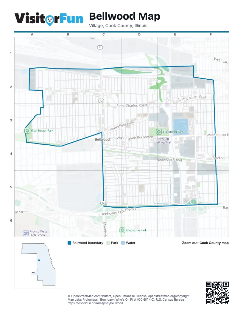
Street index of Bellwood
Each street on the sheet and the grid squares it crosses.
- 50th AvenueA1, A2, A3, A4
- Davis DriveA1, A2
- Railroad AvenueA1, B2, C2, F2, B4
- Proviso DriveB1, B2, C2
- North 25th AvenueF1, F2
- 51st AvenueA2, A3, A4
- 52nd AvenueA2, A3, A4
- Castle DriveA2
- Jerele AvenueA2, A3
- Saint Charles RoadA2, B2, C2, E2, F2, C3, D3
- Speechley BoulevardA2
- Spencer AvenueA2
- 46th AvenueB2, B3, B4
- 47th AvenueB2, B3, B4
- 48th AvenueB2, B3, B4
- 49th AvenueB2, B3, B4
- Erie StreetB2, C2, D2
- Geneva AvenueB2, B3, B4
- Granville AvenueB2, B3, B4
- Twining AvenueB2, C2, A3, B3
- Englewood AvenueC2, C3
- Frederick AvenueC2, C3, C4
- Hyde Park AvenueC2, C3
- Mannheim RoadC2, C3, C5, C6
- Marshall AvenueC2, C3, C4, C5, C6
- Marshall CourtC2
- Morris AvenueC2, C3, C4
- North Mannheim RoadC2
- Park CourtC2, C3
- Saint Charles PlaceC2, D2
- 32nd AvenueD2, D3, D5, D6
- Bellwood AvenueD2, D3, D4, D5, D6
- Bohland AvenueD2, D3, D4, D5, D6
- Eastern AvenueD2, D3, D4, D5, D6
- Grant AvenueD2, E2, F2
- Linden AvenueD2, D3, D4, D5, D6
- Rice AvenueD2, D3, D4, D5, D6
- Zuelke DriveD2, E2
- 26th AvenueE2, E3
- 27th AvenueE2, E3
- 28th AvenueE2, E3, E4
- 29th AvenueE2
- 30th AvenueE2, E5, E6
- 31st AvenueE2, E3, E4, E5, E6
- 22nd AvenueF2, F3, F4, F5
- 23rd AvenueF2, F3, F4, F5
- 24th AvenueF2, F3, F4, F5
- South 25th AvenueF2, F3, F4, F5
- 53rd AvenueA3, A4
- Bohlander AvenueA3
- Oak StreetA3, B3, C3, D3, E3, F3
- Randolph StreetA3, B3, C3, D3, E3, F3
- West Hawthorne AvenueA3
- Butterfield RoadC3, D3, B4, C4
- Miami RoadC3
- Washington BoulevardD3, E3, F3, C4, D4
- Glos StreetE3, F3
- Korrel AvenueE3
- Georgina LaneC4, D4
- Madison StreetC4, D4, E4, F4
- Monroe StreetC4, D4, E4
- Saint Paul AvenueC4, D4
- Warren AvenueC4, D4, F4
- Cernan DriveE4, E5, E6
- Maywood DriveF4
- Adams StreetC5, D5, E5, F5
- Congress StreetC5, E5, F5
- Gladys AvenueC5
- Jackson StreetC5, D5, E5
- Marik DriveC5, D5
- Van Buren StreetC5, D5, E5, F5
- Wilcox StreetC5, D5, E5
- Park PlaceD5, D6
- Harrison StreetE5, F5, C6, D6, E6
- Eisenhower ExpresswayD6
Places on the map
- Addison Creek Reservoir
- Aldi
- Apollo Park
- AutoZone
- Babe Ruth Park
- Baskin-Robbins
- Bellwood Currency Exchange
- Bellwood Post Office
- Bellwood Public Library
- Bellwood Senior Apartments
- Bellwood Village Hall
- Center At Stevenson Park
- Clark
- Covenant of Peace Ministry
- CubeSmart
- Eisenhower Community Center
- Eisenhower Park
- Jefferson Elementary School
- Kingdom Hall of Jehovah's Witnesses
- Lincoln Elementary School
- Lincoln Primary School
- Living Word Christian Academy
- Mar Thoma Sleeha Cathedral
- McDonald's
- McKinley Elementary School
- Mobil
- Providence Bank & Trust
- QuikTrip
- Roosevelt Junior High School
- Saint Gregorios Malankara Orthodox Church
- Saint John the Baptist Serbian Eastern Orthodox Church
- Saint Simeon School
- Saint Simeon's Church
- Stevenson Park
- Thorntons
- Thurgood Marshall Elementary School
- True Vine Church of God in Christ
- VFW Post 5081
- VP Fuels
- Washington Square
© OpenStreetMap contributors, Open Database License, openstreetmap.org/copyright · Map data: Protomaps · Boundary: Who's On First (CC-BY 4.0); U.S. Census Bureau















