

Illinois map
Cook County map
About 5,182,617 people live here (Census Bureau, 2024 estimate). The sheet's index lists 33 streets; Tri-State Tollway, Adlai Stevenson Expressway and Edens Expressway cross the most grid squares. Things to do inside the boundary: 360 CHICAGO Observation Deck, Adler Planetarium and Baháʼí House of Worship.
Open the map (PDF, US Letter)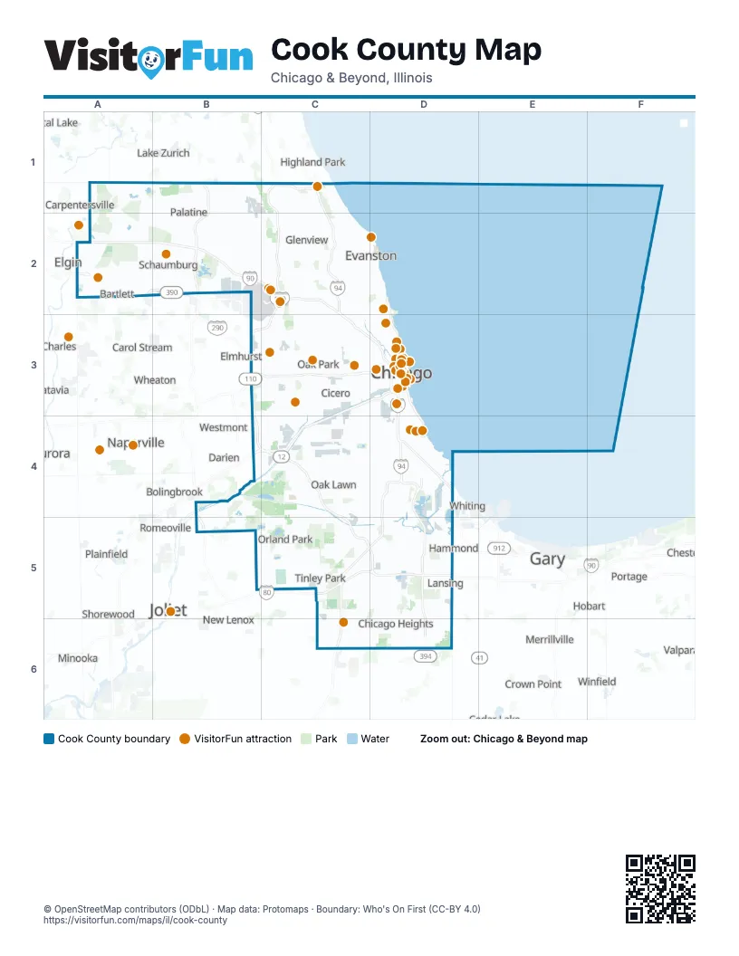
Maps inside Cook County
1 map inside, from the street map of Cook County down.
Street index of Cook County
Each street on the sheet and the grid squares it crosses.
- Edens ExpresswayC1, C2, C3
- Edens SpurC1
- Skokie HighwayC1
- Tri-State TollwayC1, C2, B3, C3, B4, C4, C5, D5
- Elgin-O'Hare TollwayA2, B2
- Jane Addams Memorial TollwayA2, B2, C2
- Martin Luther King Jr Memorial HighwayA2
- O'Hare West BypassB2
- Cumberland FlyoverC2
- Kennedy Express Reversable LaneC2, C3, D3
- Kennedy ExpresswayC2, C3, D3
- Wide Load OnlyC2
- North Jean Baptiste Point DuSable Lake Shore DriveD2, D3
- Reversable LaneD2
- Eisenhower ExpresswayB3, C3, D3
- Ronald Reagan Memorial TollwayB3
- Adlai E Stevenson ExpresswayC3
- Adlai Stevenson ExpresswayC3, D3, B4, C4
- Stevenson ExpresswayC3, D3
- Dan Ryan ExpresswayD3, D4
- Dan Ryan Expressway (Express)D3, D4
- Dan Ryan Expressway (Local)D3, D4
- Kennedy Express Reversible LaneD3
- South DuSable Lake Shore DriveD3, D4
- Des Plaines River Valley BridgeB4
- Joliet RoadB4, C4
- Veterans Memorial TollwayB4, B5
- Bishop Ford FreewayD4, D5
- Chicago SkywayD4
- Stony Island ExpresswayD4
- Borman ExpresswayD5
- Calumet ExpresswayD5, D6
- Kingery ExpresswayD5
Things to do on the Cook County map
- 360 CHICAGO Observation Deck
- Adler Planetarium
- Baháʼí House of Worship
- Best Western at O'Hare
- Big Bus Tours Chicago
- Broadway In Chicago
- Brookfield Zoo Chicago
- Buckingham Fountain
- Buddy Guy's Legends
- Catalog at Willis Tower
- Chicago
- Chicago Architecture Center River Cruise
- Chicago Botanic Garden
- Chicago Crime Tours
- Chicago Cultural Center
- Chicago History Museum
- Chicago Northwest
- Chicago Oyster House
- Chicago Prime Tours
- Chicago Riverwalk
- Chicago Southland
- Chicago Water Tower
- Chicago's First Lady
- Chinatown
- Color Factory Chicago
- Congress Plaza Hotel
- Crowne Plaza Chicago O'Hare Hotel & Conference Center
- DuSable Black History Museum and Education Center
- Embassy Suites by Hilton Chicago Downtown Magnificent Mile
- Federal Reserve Bank of Chicago Money Museum
- Field Museum
- Flyover Chicago
- Frank Lloyd Wright Home and Studio
- Frederick C. Robie House
- Garfield Park Conservatory
- Grant Park
- Green Mill
- Griffin Museum of Science and Industry
- HI Chicago, The J. Ira and Nicki Harris Family Hostel
- Hilton Rosemont Chicago O'Hare
- Hyatt Regency Chicago
- International Museum of Surgical Science
- La Quinta Inn & Suites by Wyndham Chicago Downtown
- Lincoln Park Zoo
- Millennium Park & Cloud Gate (The Bean)
- Museum of Broadcast Communications
- Museum of Contemporary Art Chicago
- Navy Pier
- Rate Field
- Shedd Aquarium
- Skydeck Chicago
- Skydeck Chicago at Willis Tower
- Soldier Field
- Sonesta Chicago O'Hare Airport Rosemont
- The Art Institute of Chicago
- The Auditorium
- The Chicago Theatre
- The Magnificent Mile
- The Pinball Capital
- The Second City
- Travelodge by Wyndham Downtown Chicago
- United Center
- Villa Olivia
- Wendella Sightseeing Boats
- Wrigley Field Tours
Places on the map
- 26th Street Woods
- 31st Street Harbor
- 35 East Wacker
- 45 Crossover
- 49th Ward
- Abt Electronics Inc
- ACH Ingredion
- Albany Park
- Algonquin Woods Preserve
- Allison Woods Preserve
- Alpine Village
- Alsip
- Altgeld Gardens Homes
- Archer Heights
- Argyle Street
- Arie Crown Forest
- Arlington Heights
- Arlington Park
- Ashburn
- Auburn Gresham
- Austin
- Auto Warehousing Company
- Avalon Park
- Avondale
- Baker's Lake
- Barlett Hills Golf Club
- Barrington
- Barrington Highlands
- Barrington Hills
- Barrington Square
- Barrington Township
- Bataan Park
- Beat 2511
- Beat 2512
- Beat 2513
- Beat 2514
- Beat 2515
- Beat 2521
- Beat 2522
- Beat 2523
Next to Cook County
- Aurora
- Batavia
- Bolingbrook
- Carol Stream
- Carpentersville
- Cary
- Channahon
- Chesterton
- Crown Point
- Crystal Lake
- Darien
- Elgin
- Elmhurst
- Gary
- Hammond
- Highland Park
- Hobart
- Joliet
- Lake Station
- Lake Zurich
- Lombard
- Merrillville
- Minooka
- Naperville
- New Lenox
- Plainfield
- Portage
- Romeoville
- Shorewood
- St. Charles
- St. John
- Valparaiso
- Vernon Hills
- Westmont
- Wheaton
- Whiting
- Winfield
© OpenStreetMap contributors (ODbL) · Map data: Protomaps · Boundary: Who's On First (CC-BY 4.0)