

Illinois map
Berwyn map
About 55,152 people live here (Census Bureau, 2024 estimate). The sheet's index lists 91 streets; Maple Avenue, Wesley Avenue and Clinton Avenue cross the most grid squares. Also on it: Cermak Plaza Shopping Center, MacNeal Hospital and Morton West High School.
Open the map (PDF, US Letter)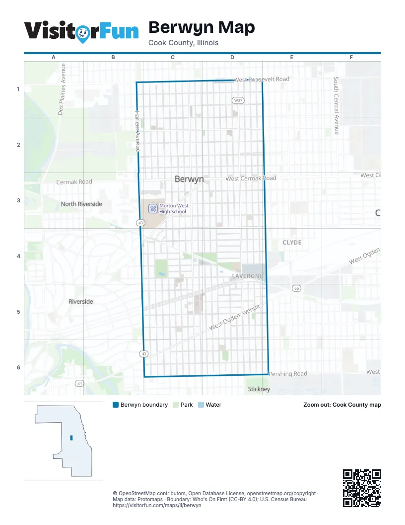
Street index of Berwyn
Each street on the sheet and the grid squares it crosses.
- Maple AvenueB1, C1, C2, C3, C4, C5, C6
- 13th StreetC1, D1, E1
- 14th StreetC1, D1, E1
- Clinton AvenueC1, C2, C3, C4, C5, C6
- Euclid AvenueC1, C2, C3, C4, C5, C6
- Grove AvenueC1, C2, C3, C4, C5, C6
- Home AvenueC1, C2, C3, C4, C5, C6
- Kenilworth AvenueC1, C2, C3, C4, C5, C6
- Oak Park AvenueC1, C2, C3, C4, C5, C6
- Wenonah AvenueC1, C2, C3, C4, C5, C6
- Wesley AvenueC1, C2, D2, D3, D4, D5, D6
- Wisconsin AvenueC1, C2, C3, C4, C5, C6
- 15th StreetD1, E1, C2, D2
- Clarence AvenueD1, D2, D3, D4, D5, D6
- Cuyler AvenueD1, D2, D3, D4, D5, D6
- East AvenueD1, D2, D3, D4, D5, D6
- Elmwood AvenueD1, D2, D3, D4, D5, D6
- Gunderson AvenueD1, D2, D3, D4, D5, D6
- Highland AvenueD1, D2, D3, D4, D5, D6
- Ridgeland AvenueD1, D2, D3, D4, D5, D6
- Scoville AvenueD1, D2, D3, D4, D5, D6
- South Cuyler AvenueD1
- South East AvenueD1
- South Harvey AvenueD1, D2, D3
- West Roosevelt RoadD1
- South Lombard AvenueE1, E2, E3, E4, E5, E6
- West 14th StreetE1
- 16th StreetB2, C2, D2, E2
- 18th StreetB2, C2, D2, E2
- 19th StreetB2, C2, D2, E2
- 21st StreetB2, C2, D2, E2
- Greenberg RoadB2
- Harlem AvenueB2
- Red RoadB2
- South Harlem AvenueB2, B3, B4, B5, C5, C6
- 19th Street SouthD2, E2
- West 16th StreetE2
- West 19th StreetE2
- West 21st StreetE2
- West 25th StreetB3, E3
- West Cermak RoadB3, C3, D3
- 23rd StreetC3, D3, E3
- 24th StreetC3, D3, E3
- 25th StreetC3, D3, E3
- Riverside DriveC3, D3, C4
- West 26th StreetC3, D3, B4, C4
- Harvey AvenueD3, D4, D5, D6, E6
- West 23rd StreetE3
- West 24th StreetE3
- 30th StreetB4, C4, D4
- 31st StreetB4, C4, D4
- Lindberg RoadB4
- Shenstone RoadB4
- York RoadB4
- 26th ParkwayC4
- 26th PlaceC4, D4
- 27th StreetC4, D4, E4
- 28th StreetC4, D4, E4
- 29th PlaceC4
- 29th StreetC4, D4
- 30th PlaceC4
- 27th PlaceD4
- 28th PlaceD4
- Park AvenueD4
- South Highland AvenueD4, D5
- Stanley AvenueD4, B5, C5, D5
- Windsor AvenueD4, B5, C5, D5
- West 27th StreetE4
- West 28th StreetE4
- 32nd StreetB5, C5, D5
- 34th StreetB5, C5, D5
- Addison RoadB5
- East Burlington StreetB5
- Herrick RoadB5
- Lawton RoadB5
- Quincy StreetB5
- 33rd StreetC5, D5
- 35th StreetC5, D5
- West Ogden AvenueC5, D5, E5, C6
- 36th StreetD5, E5, C6
- Fairfield AvenueD5
- Sinclair AvenueD5
- West 34th StreetD5
- West 35th StreetD5, E5
- West 36th StreetE5
- 37th StreetC6, D6, E6
- 38th PlaceC6
- 38th StreetC6, D6, E6
- Pershing RoadC6, D6, E6
- West 37th StreetE6
- West 38th StreetE6
Places on the map
- 7-Eleven
- AutoZone
- Bank of America
- Baseball Alley
- Benjamin Moore
- Berwyn Ace Hardware
- Berwyn City Hall
- Berwyn Fire Department Station 1
- Berwyn Fire Department Station 2
- Berwyn Gardens Park
- Berwyn Kia
- Berwyn Medical Center
- Berwyn Moose Lodge 424
- Berwyn Police Department
- Berwyn Post Office
- Berwyn Public Library
- Berwyn Recreation Center
- Berwyn Shops
- Berwyn Towne Square
- Berwyn United Lutheran Church
- Big Hurt Brewhouse
- BMO
- Byline Bank
- Cermak Plaza Shopping Center
- Chase
- Christian Life Center
- Church of Christ
- Circle K
- Concordia Lutheran Church
- Culver's
- Dollar General
- Ebenezer Christian Reformed Church
- Emerson Elementary School
- Emmanuel Bible Church
- Extra Space Storage
- Gateway Plaza
- Janura Park
- MacNeal Hospital
- Morton West High School
- Proksa Park
Next to Berwyn
- Clyde
- North Riverside
- Riverside
- Stickney
© OpenStreetMap contributors, Open Database License, openstreetmap.org/copyright · Map data: Protomaps · Boundary: Who's On First (CC-BY 4.0); U.S. Census Bureau















