

Illinois map
Centralia map
About 13,839 people live here (Census Bureau, 2024 estimate). The sheet's index lists 286 streets; East McCord Street, South Maple Street and West 4th Street cross the most grid squares. Also on it: Centralia Municipal Airport, Foundation Park and Foundation Park Wetlands.
Open the map (PDF, US Letter)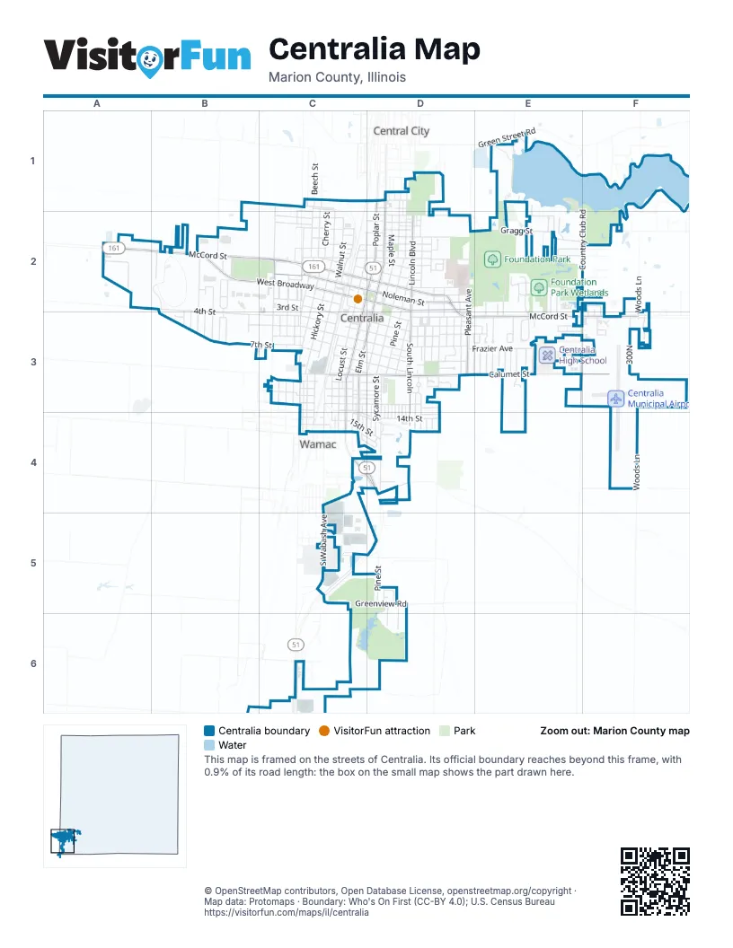
Street index of Centralia
Each street on the sheet and the grid squares it crosses.
- Aaron ParkwayC1, C2
- Beech StreetC1
- College AvenueC1, C2
- Gilmore StreetC1, C2
- Monroe StreetC1
- North Beech StreetC1, C2
- North Cherry StreetC1, C2
- North Gary StreetC1
- North Hickory StreetC1, C2
- Wilson AvenueC1, C2
- Allison AvenueD1
- Andrews StreetD1
- Charlotte StreetD1
- McKee StreetD1, D2
- North Elm StreetD1, D2
- North Poplar StreetD1, C2, D2
- North Sycamore StreetD1, D2
- Richmond HeightsD1
- South BroadwayD1
- Arbor LaneE1
- Chipwood LaneE1, F1, E2
- Club House RoadE1, E2
- Green Street RoadE1
- Spillway LaneE1
- Country Club RoadF1, F2
- Deerwood ParkA2
- Harting DriveA2
- West 4th StreetA2, B2, B3, C3
- West McCord StreetA2, B2, C2
- Adrienne DriveB2
- Bruce CourtB2
- Buena Vista TerraceB2
- Clarida DriveB2, B3
- Clinton RoadB2
- Janet DriveB2, B3
- Jolliff Bridge RoadB2
- Middle StreetB2
- Murray DriveB2, B3
- Oak Park Drive EastB2
- Oak Park Drive WestB2
- Outer DriveB2
- Randolph DriveB2, B3
- Ruth Ann DriveB2
- Sunset DriveB2, B3
- Watts LaneB2
- West 7th StreetB2, B3, C3
- West BroadwayB2, C2
- Woodlawn TrailB2
- 2nd StreetC2
- Clinmar PlaceC2
- Condit StreetC2
- Dimick StreetC2
- East 2nd StreetC2, D2, D3
- East BroadwayC2, D2
- East Kell StreetC2, D2
- East Kerr StreetC2, D2
- East McCord StreetC2, D2, D3, E3, F3
- East Rexford StreetC2, D2
- Howard StreetC2, D2
- Johnson AvenueC2
- Johnson StreetC2
- Kell StreetC2
- Kerr StreetC2
- Loren PlaceC2
- Lorena PlaceC2
- North Brooks AvenueC2
- North Chestnut StreetC2
- North James AvenueC2
- North Locust StreetC2, D2
- North Oak StreetC2
- North Pullen BoulevardC2
- North Tate AvenueC2
- North Walnut StreetC2
- Parker StreetC2
- Penco AvenueC2
- Penn AvenueC2
- Pullen BoulevardC2
- Rhodes StreetC2, D2
- South Beech StreetC2, C3
- South Brookside AvenueC2, C3
- South Cherry StreetC2, C3, C4
- South Chestnut StreetC2, C3
- South Hickory StreetC2, C3, C4
- South JamesC2
- South Locust StreetC2, C3, C4
- South Oak StreetC2, C3
- South Poplar StreetC2, C3, C4, D4
- South Pullen BoulevardC2, C3
- South Walnut StreetC2, C3, C4
- Washington BoulevardC2
- West 2nd StreetC2
- West 3rd StreetC2, C3
- West Kell StreetC2
- West Kerr StreetC2
- West Noleman StreetC2, D2
- West Rexford AvenueC2
- West Rexford StreetC2
- Cormick StreetD2
- East Jonas StreetD2
- East McCord RoadD2
- East Noleman StreetD2
- East Rasback StreetD2
- Franklin StreetD2
- Gragg StreetD2, E2, F2
- Haussler StreetD2
- Jackson AvenueD2
- M L King DriveD2
- Maulding DriveD2
- North Davis AvenueD2
- North Lincoln BoulevardD2
- North Maple StreetD2
- North Meyer AvenueD2, D3
- North Perrine AvenueD2
- North Pine StreetD2
- North Pleasant AvenueD2
- Perrine AvenueD2, D4
- Pleasant AvenueD2, E2
- Robnett DriveD2
- Sadler DriveD2
- Sadler PlaceD2
- South Davis AvenueD2, D3
- South Elm StreetD2, C3, D3, C4
- South LincolnD2, D3, D4
- South Maple StreetD2, C3, D3, C4, D4
- South Perrine AvenueD2, D3
- South Pine StreetD2, D3, D4, D5
- South Pleasant AvenueD2, D3
- South Sycamore StreetD2, D3, D4
- Sycamore StreetD2
- Watson LaneD2
- Wright DriveD2
- Bel-Air DriveE2, E3
- BlackberryE2
- Blackberry RunE2, E3
- Clearlake DriveE2
- Edgewood Lane NorthE2, E3
- Estate DriveE2, E3
- Lakewood DriveE2, F2
- Park ForestE2
- Park Forest DriveE2
- Parkview DriveE2, E3
- Penta WayE2, F2
- Phyllis DriveE2
- Sanders Private DriveE2
- Sherwood DriveE2
- Devonia DriveF2, F3
- Edgebrook LaneF2
- Fairway DriveF2
- Golf LaneF2
- Marilyn AvenueF2
- Meadow LaneF2
- Roseclair LaneF2, F3
- Tee LaneF2
- Trenton LaneF2, F3
- Easthaven DriveB3
- Esther DriveB3
- Geary StreetB3
- West 5th StreetB3, C3
- Westhaven DriveB3
- 10th StreetC3
- 11th StreetC3
- 12th StreetC3
- 14th StreetC3
- 4th StreetC3, E3
- 5th StreetC3
- 8th StreetC3
- Bond StreetC3
- Calumet StreetC3
- Case StreetC3
- Delores StreetC3
- Dover StreetC3
- East 10th StreetC3, D3
- East 11th StreetC3, D3
- East 12th StreetC3, D3
- East 13th StreetC3, D3
- East 14th StreetC3, C4, D4
- East 3rd StreetC3, D3, E3
- East 4th StreetC3, D3, E3
- East 5th StreetC3, D3
- East 6th StreetC3, D3
- East 7th StreetC3, D3
- East 8th StreetC3, D3
- East CalumetC3, D3
- Fayette StreetC3
- Hester AvenueC3, C4
- Marion AvenueC3, C4
- South Marion AvenueC3
- Wabash AvenueC3, C4
- West 10th StreetC3
- West 11th StreetC3
- West 12th StreetC3
- West 13th StreetC3
- West 14th StreetC3
- West 6th StreetC3
- West Calumet StreetC3
- Anderson StreetD3
- Arline DriveD3, E3
- Cedar StreetD3, D4
- Charles DriveD3
- Circle DriveD3
- Davis AvenueD3
- Dean StreetD3, D4
- East Calumet StreetD3, E3, F3
- Evergreen DriveD3
- Frazier AvenueD3, E3
- Gardner DriveD3
- Greve DriveD3
- Leafland AvenueD3
- Lilac LaneD3
- Linden AvenueD3
- Marquis AvenueD3
- MelroseD3
- Melrose AvenueD3
- Mitchell AvenueD3, D4
- Nelms AvenueD3, D4
- Orchard DriveD3
- Orchard Drive EastD3
- Sara DriveD3, E3
- Short StreetD3, D4
- South Lincoln BoulevardD3, D4
- South PerrineD3, D4
- Aero DriveE3
- Agape LaneE3, F3
- Airport RoadE3, F3
- Bonanza DriveE3, F3
- Briarwood DriveE3
- Calumet Estates DriveE3
- Cessna DriveE3, F3
- Coronado DriveE3
- Edgewood Lane SouthE3
- Gayla AvenueE3
- Glenda AvenueE3
- Holiday TerraceE3
- JonesE3
- Kristy DriveE3
- Meadowbrook LaneE3
- Nancy DriveE3
- Oakdale DriveE3
- Osage DriveE3
- Park LaneE3
- Pine Hurst PlaceE3
- Redwood DriveE3
- Ridge RoadE3
- Ronnies TerraceE3
- Sable DriveE3
- Spruce DriveE3
- Sunnyside DriveE3
- Tracy TerraceE3
- 300NF3
- County Road 290 EastF3
- Crestwood LaneF3
- East McCordF3
- Heritage CircleF3
- Woods LaneF3, F4
- 15th StreetC4
- 17th StreetC4
- East 15th StreetC4, D4
- East 16th StreetC4
- East 17th StreetC4
- Elm StreetC4, D4
- GilmoreC4
- Hickory Meadows DriveC4, D4
- James StreetC4
- West 15th StreetC4
- West 16th StreetC4
- West 17th StreetC4
- D Ann DriveD4
- Holly StreetD4
- Jonquil StreetD4
- Kroger StreetD4
- Magnolia StreetD4
- Shawnee RoadD4
- Walnut Hill RoadD4
- Copple RoadF4
- Greenview RoadC5, D5
- Mitchell LaneC5
- South Wabash AvenueC5
- Swan AvenueC5
- Swan DriveC5
- Andrew DriveD5
- Eastwood LaneD5, D6
- Greenview Country ClubD5, C6, D6
- Greenwood DriveD5, D6
- Hannah CourtD5
- Greenview Church RoadC6
- Lingle LaneC6
Places on the map
- 2500 Engine
- Ace Hardware
- ALDI
- Ameren Power company
- AutoZone
- Bell Tower Park
- Best Western Plus
- Bible Based Community Church
- Big Lots
- Body Shoppe Gym
- Borowiak's IGA
- Bucheit
- Burger King
- Byrd-Watson Medical Equipment
- Calumet Street Christian Church
- Castle Ridge
- Catfish Pond
- Centralia City Fire Department
- Centralia Historical Society
- Centralia Motel
- Centralia Municipal Airport
- Centralia Police Station
- Centralia Post Office
- Centralia Public Library
- Centralia Recreation Center
- Centralia Recycling Center
- Centralia Town Hall
- Circle K
- City Hope Church
- Community Church of Christ
- Elmwood Cemetery
- Fairview Park
- Foundation Park
- Foundation Park Sprehe Fields
- Foundation Park Wetlands
- Greenview Golf Club
- Meadow Woods
- Point Park
- Raccoon Lake
- Saint Mary's Hospital
Next to Centralia
- Central City
- Wamac
© OpenStreetMap contributors, Open Database License, openstreetmap.org/copyright · Map data: Protomaps · Boundary: Who's On First (CC-BY 4.0); U.S. Census Bureau















