

Illinois map
Hazel Crest map
About 13,036 people live here (Census Bureau, 2024 estimate). The sheet's index lists 186 streets; 167th Street, Kedzie Avenue and Central Park Avenue cross the most grid squares. Also on it: Advocate South Suburban Hospital, Chateaux Elementary School and Fountainbleau.
Open the map (PDF, US Letter)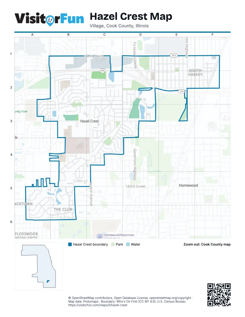
Street index of Hazel Crest
Each street on the sheet and the grid squares it crosses.
- 167th StreetA1, B1, C1, D1, E1, F1
- Lawndale AvenueA1, A4, A5
- Central Park AvenueB1, B2, B3, B6
- Hillcrest DriveB1
- Plainview DriveB1
- Spaulding AvenueB1
- Turner AvenueB1
- Wedgewood DriveB1
- Albany AvenueC1, C2
- Kedzie AvenueC1, C2, C3, C4, C5
- Sacremento StreetC1
- 168th StreetD1, E1, F1
- Artesian AvenueD1
- Circle DriveD1
- Crescent DriveD1
- Plaza Service RoadD1
- Sunset RoadD1
- Tri-State TollwayD1, D2, E2
- Western AvenueD1, D2
- Anthony AvenueE1, E2
- Baron DriveE1
- Bulger AvenueE1, E2
- Crane AvenueE1, E2
- Dixie HighwayE1, E2
- Head AvenueE1, E2
- Orchard Ridge AvenueE1, E2
- Robey StreetE1, E2
- Shea AvenueE1, E2
- Trapet AvenueE1, E2
- Winchester AvenueE1, E2
- Charleston LaneF1
- Jodave AvenueF1, F2
- Lincoln StreetF1, F2
- Page AvenueF1, F2
- Park AvenueF1, F2
- Paulina AvenueF1, F2
- Wolcott AvenueF1
- Wood StreetF1, F2
- 172nd StreetA2, C2, D2
- Appletree DriveA2, A3
- Cottonwood CourtA2
- Peach Grove LaneA2, B2, A3
- 172nd CourtB2, C2
- Briarwood Drive SouthB2, C2
- Chestnut CourtB2
- Chestnut DriveB2
- Elm DriveB2, B3
- Hazel LaneB2, B3
- Laurel LaneB2, C2
- Locust DriveB2
- Magnolia DriveB2
- Maple CourtB2
- Maple LaneB2, C2
- Oak CourtB2
- Oak StreetB2
- Pine CourtB2
- Springtide LaneB2, B3
- Tulip DriveB2
- Woodworth PlaceB2, C2, D2
- 170th StreetC2, D2, E2, F2
- 171st StreetC2, D2, E2, F2
- California AvenueC2, D2, D3
- Emerson AvenueC2, C3
- Holmes AvenueC2, C3
- Kaindl DriveC2
- Linder DriveC2
- Longfellow AvenueC2, C3
- Novak DriveC2
- Park LaneC2
- Whitman AvenueC2
- Whittier AvenueC2
- 169th StreetD2, E2, F2
- Annetta AvenueD2
- Concord PlaceD2
- Highland AvenueD2
- Highland CourtD2, D3
- Hillside AvenueD2
- Mahoney ParkwayD2, D3
- Murphy AvenueD2
- Palmer BoulevardD2, D3
- Rockwell AvenueD2
- Summit AvenueD2
- 173rd StreetE2, B3, C3, D3
- Country Club DriveA3
- Coventry CourtA3
- Glynwood LaneA3, B3
- Tamarind LaneA3, B3
- Wellington CourtA3, B3
- Wellington DriveA3
- Wheelwood CourtA3
- 175th StreetB3, C3, D3, E3
- Burr Oak LaneB3
- Hickory CourtB3
- Hickory LaneB3
- South Suburban Hospital DriveB3, B4
- Sycamore DriveB3
- West 177th StreetB3, C3
- Yale LaneB3
- 174th StreetC3, D3
- Arlington LaneC3, C4
- Balmoral LaneC3, C4
- Bryant LaneC3
- Cherrywood LaneC3, D3
- Coach LaneC3
- East Carriageway DriveC3
- Grandview DriveC3, C4
- Hawthorne LaneC3
- Knollwood PlaceC3, D3
- Larkspur LaneC3, D3
- Lexington DriveC3, D3
- Lowell AvenueC3
- Oakwood DriveC3, D3, C4
- Poe AvenueC3
- Stonebridge DriveC3, C4
- Surrey LaneC3, C4
- Tennyson PlaceC3, D3
- Turtlecreek DriveC3, D3
- Butternut RoadD3
- Danielle CourtD3
- Governors HighwayD3
- Jovanna StreetD3
- Lincoln AvenueD3
- Bordeaux CourtB4, B5
- Burgundy LaneB4
- Chambord LaneB4
- Chantilly LaneB4
- Charlemagne AvenueB4, C4, B5
- Chartres CourtB4
- Elysees CourtB4
- Fountainbleau DriveB4, C4, B5
- Montmarte AvenueB4
- Normandy LaneB4
- Orleans DriveB4, B5
- Royale LaneB4
- Versailles LaneB4, B5
- 179th StreetC4
- Buttonwood WalkC4
- Dogwood LaneC4
- Greenwood RoadC4
- Hickory RoadC4
- Millstone RoadC4
- Old Trail RoadC4
- Pebblewood LaneC4
- Ridgewood DriveC4
- Shagbark LaneC4
- Smoke Tree CourtC4
- Tanglewood CourtC4
- Tarpon CourtC4
- Carrington CourtA5
- Carrington DriveA5
- Collins DriveA5
- Crystal CourtA5
- Edgewater DriveA5, A6
- Michael CourtA5, A6
- Pulaski RoadA5, A6
- River RoadA5, B5, A6, B6
- Streamwood DriveA5, A6
- Village DriveA5, B5, A6, B6
- Williamsburg RoadA5
- 183rd StreetB5, C5
- Alexis CourtB5, B6
- Brentwood DriveB5
- Cannes CourtB5
- Grenoble DriveB5
- Harseille LaneB5
- Kimball AvenueB5
- Knollwood LaneB5
- Lakeview DriveB5
- Marseilles LaneB5
- Meadow LaneB5, B6
- Seine CourtB5
- Stone Creek DriveB5
- Mallard DriveC5
- Olive RoadC5
- 187th StreetA6
- Briar LaneA6, B6
- Brumley DriveA6, B6
- Elm StreetA6
- Indie CourtA6
- Michael DriveA6
- Springfield StreetA6
- Ash StreetB6
- Augusta LaneB6
- Emily CourtB6
- Golfview DriveB6
- Robert CourtB6
Places on the map
- A.P. Deli
- Advocate South Suburban Hospital
- American Legion Hall
- Anytime Fitness
- Ariston's
- AutoZone
- Bike Doctors
- Boz Hot Dogs
- BP Shop
- Burger King
- Caribbean Haus Seafood Kitchen
- Chateaux Elementary School
- Cherrywood Park
- Citgo
- Dialysis Care Center
- Former ALDI
- Fountainbleau
- Goodwill
- Grande Prairie Public Library
- Hazel Crest Center
- Hazel Crest Fire Department
- Hazel Crest Post Office
- Hazel Crest School District 152.5
- Hazel Crest Village Hall
- Highlands Elementary School
- James O. Setnes Sports Complex
- Jesse White Learning Academy
- Mae Jemison Elementary School
- O'Reilly Auto Parts
- Oak Hill Park
- Saint Anne Church
- South Suburban Medical Center
- Stone Hollow Park
- Swimming Pool for apartments
- Teddy's Fruit & Meat Market
- The Commons of Hazel Crest
- Walgreens
- Wendy's
- Wolf Park
Next to Hazel Crest
- Flossmoor Highlands
- Homewood map
- Privincetown
© OpenStreetMap contributors, Open Database License, openstreetmap.org/copyright · Map data: Protomaps · Boundary: Who's On First (CC-BY 4.0); U.S. Census Bureau















