

Illinois map
La Grange map
About 15,943 people live here (Census Bureau, 2024 estimate). The sheet's index lists 137 streets; South Kensington Avenue, South 7th Avenue and South La Grange Road cross the most grid squares. Also on it: Denning Park, Gordon Park and La Grange Field Club.
Open the map (PDF, US Letter)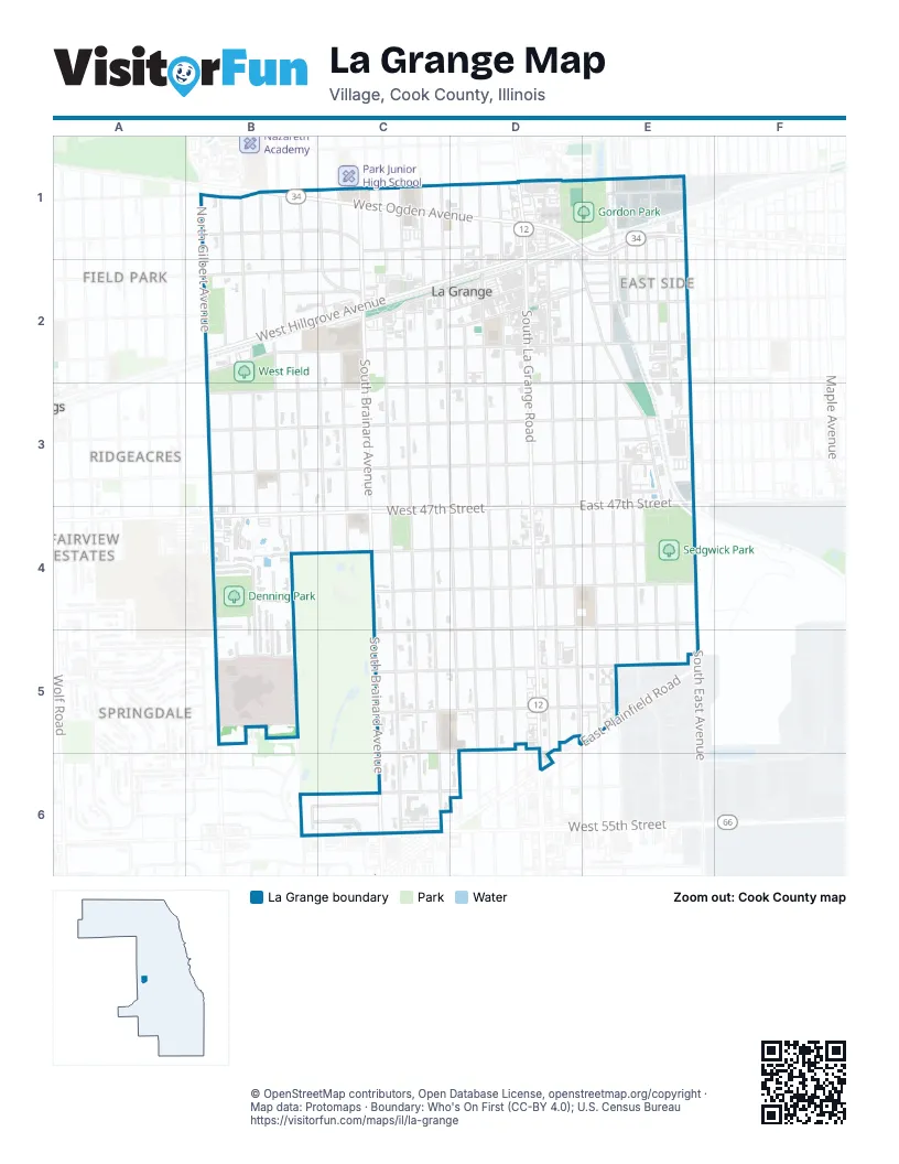
Street index of La Grange
Each street on the sheet and the grid squares it crosses.
- 39th StreetB1
- North Bassford AvenueB1
- North Drexel AvenueB1, B2
- North Edgewood AvenueB1, B2
- North Malden AvenueB1, B2
- North Peck AvenueB1, B2
- West Bell AvenueB1, C1, D1
- West Ogden AvenueB1, C1, D1
- Brainard AvenueC1
- Brewster AvenueC1
- Dover AvenueC1, C2
- North Brainard AvenueC1, C2
- North Kensington AvenueC1, C2
- North Park RoadC1, C2
- North Spring AvenueC1, C2
- North Stone AvenueC1, C2
- North Waiola AvenueC1, C2
- Ashland AvenueD1, D2
- Beacon AvenueD1
- Bluff AvenueD1, E2, E3, E4
- East Burlington AvenueD1, E1, D2
- East Hillgrove AvenueD1
- East Ogden AvenueD1, E1
- Locust AvenueD1
- North Ashland AvenueD1
- North Catherine AvenueD1, D2
- North La Grange RoadD1
- North Madison AvenueD1, D2
- Shawmut AvenueD1, E1
- South 7th AvenueD1, D2, D3, D4, D5
- South La Grange RoadD1, D2, D3, D4, D5
- West Brewster AvenueD1
- West Hillgrove AvenueD1, B2, C2, D2
- Beach AvenueE1
- East Avenue - Eberly AvenueE1, E2, E3
- Finley AvenueE1
- Hayes AvenueE1, E2
- Hazel AvenueE1
- Newberry AvenueE1
- North Kemman AvenueE1
- Sawyer AvenueE1, E2
- South Tilden AvenueE1, E2
- Southview AvenueE1
- Tilden AvenueE1
- Washington AvenueE1, E2
- 42nd StreetB2
- Burlington AvenueB2
- Elder LaneB2
- Hillgrove AvenueB2
- North Gilbert AvenueB2
- Poplar PlaceB2
- South Edgewood AvenueB2, B3, B4, B5
- South Gilbert AvenueB2, B3, B4
- South Leitch StreetB2
- South Peck AvenueB2, B3, B4
- South Sunset AvenueB2, B3, B4
- West 41st StreetB2, C2
- West Arlington AvenueB2, C2
- West Cossitt AvenueB2, C2, D2
- Dover PlaceC2
- South Blackstone AvenueC2, C3, C4
- South Brainard AvenueC2, C3, C4, C6
- South Kensington AvenueC2, C3, D3, D4, D5, D6
- South Park RoadC2, C3, C4
- South Spring AvenueC2, C3, C4, C5, C6
- South Stone AvenueC2, C3, C4, C5, C6
- South Waiola AvenueC2, C3, C4, C5, C6
- Stone AvenueC2
- West Burlington AvenueC2, D2
- West Calendar AvenueC2, D2
- West Harris AvenueC2, D2
- East Calendar AvenueD2, E2
- East Cossitt AvenueD2, E2
- East Elm AvenueD2, E2, D3
- East Harris AvenueD2, E2
- South 6th AvenueD2, D3, D4, D5
- South Ashland AvenueD2, D3, D4, D5
- South Catherine AvenueD2, D3, D4, D5
- South Madison AvenueD2, D3, D4, D5
- Congress Park AvenueE2, E3
- East Franklin AvenueE2
- East Lincoln AvenueE2
- Rochester AvenueE2
- Shields AvenueE2
- South 8th AvenueE2, E3, E4, E5
- South 9th AvenueE2, E3, E4, E5
- 45th StreetB3
- 46th StreetB3
- South Leitch AvenueB3, B4
- West Elm AvenueB3, C3, D3
- West Goodman AvenueB3, C3, D3
- West Maple AvenueB3, C3, D3
- East 47th StreetD3, E3, D4
- East Goodman AvenueD3, E3
- East Maple AvenueD3, E3
- 47th StreetE3, B4
- Ashley AvenueE3
- Benton AvenueE3
- Filson StreetE3
- Gerritsen AvenueE3
- Hansen AvenueE3
- Sahler AvenueE3
- South 10th AvenueE3, E4, E5
- South East AvenueE3, E4, E5
- Banyon LaneB4
- Birks CourtB4
- Brighton LaneB4, B5
- Carriage LaneB4
- Garden Market StreetB4
- Glenwood LaneB4
- Mason DriveB4, B5
- South Willow Springs RoadB4, B5
- West 47th StreetB4, C4, D4
- West 50th StreetB4, D4, C5, D5
- West Linklater CourtB4, C4
- West 48th StreetC4, D4
- West 49th StreetC4, D4
- East 48th StreetD4, E4
- East 49th StreetD4, E4
- East 50th StreetD4, E4
- South 11th AvenueE4, E5
- South 12th AvenueE4, E5
- 51st StreetB5
- Community Memorial DriveB5
- Hilberry CourtB5
- West 51st StreetB5, C5, D5
- West 52nd PlaceB5
- West 52nd StreetC5, D5
- West 53rd StreetC5, D5, C6
- East 51st StreetD5, E5
- East 52nd StreetD5, E5
- East Plainfield RoadE5
- Calle View DriveB6, C6
- Country Club DriveB6, C6
- South Edgewood LaneB6
- West 55th StreetB6, C6
- West 54th StreetC6, D6
Places on the map
- American Legion Hall Post 1941
- Aurelio's Pizza
- Bank of America
- Beds Plus
- BMO
- Chase
- Community Center
- Corner Bakery
- Cossitt Avenue Elementary School
- Creative World Montessori School
- Denning Park
- Emmanuel Episcopal Church
- First Baptist Church
- First Baptist Church of La Grange
- First Congregational Church
- First Presbyterian Church of La Grange
- First United Methodist Church
- Gemini Gymnastics Academy
- Gilbert Park
- Gordon Park
- Grace Lutheran Church
- Gurrie Middle School
- La Grange Bible Church
- La Grange Field Club
- La Grange Fire Department
- La Grange Post Office
- La Grange Public Library
- La Grange Theater
- La Grange Village Hall
- LADSE Main Office
- LaGrange Police Department
- Lyons Township High School North Campus
- Sedgwick Park
- The UPS Store
- UChicago Medicine AdventHealth La Grange
- West Field
Next to La Grange
- Fairview Estates
- Field Park
- Ridgeacres
- Springdale
© OpenStreetMap contributors, Open Database License, openstreetmap.org/copyright · Map data: Protomaps · Boundary: Who's On First (CC-BY 4.0); U.S. Census Bureau















