

Illinois map
Lemont map
About 22,918 people live here (Census Bureau, 2024 estimate). The sheet's index lists 300 streets; Archer Avenue, Main Street and State Street cross the most grid squares. Also on it: Great Lakes Quarry, Illinois and Michigan Canal and The Forge: Lemont Quarries.
Open the map (PDF, US Letter)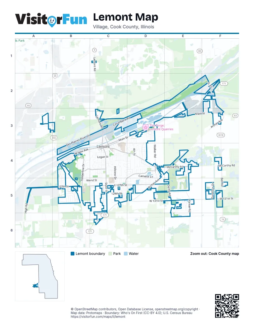
Street index of Lemont
Each street on the sheet and the grid squares it crosses.
- Veterans Memorial TollwayB3, B5
- Des Plaines River Valley BridgeB3, B4
- Archer AvenueF2, F3, D4, E4, C5, D5, C6
- Main StreetC3, D3, E3, F3, C4
- State StreetC3, C4, C5, C6
- Lemont RoadC1, C3
- West New AvenueB4, C4
- East Illinois StreetC3, C4
- Calumet Sag RoadF2, F3
- IL 83F2
- South Archer AvenueC6
- Lockport StreetC4
- McCarthy RoadC4, D4, E4, F4
- 127th StreetA5, B5, C5, D5
- Bell RoadF3, F4, F5
- East 127th StreetC5, D5
- Stephen StreetC3, C4
- West 131st StreetC5, D5, E5, F5
- Covington DriveD4, C5, D5
- Timberline DriveB4, B5
- Walker RoadD3, D4
- Parker RoadE5, E6
- West Peiffer AvenueB4, C4
- Peiffer AvenueB4, C4
- Smith RoadB5
- West 135th StreetC6
- 109th StreetC3
- Ruffled Feathers DriveE4, E5
- Derby RoadE4, E5
- Canal Bank RoadC3, D3
- 4th StreetD3, D4
- Des Plaines River DriveC3, B4
- Camelot LaneD4, D5
- Kromray RoadD3, D4
- Warner AvenueC4, C5
- Keepataw DriveC4
- Hillview DriveC4, C5
- Long Cove DriveD5, E5
- West Logan StreetB4, C4
- Anne DriveE5, E6
- High RoadA5
- Waterford DriveF5
- Thornberry DriveB4, B5
- Woodcrest LaneD4
- Rolling Meadow DriveB5
- Singer AvenueC4
- 129th StreetC5
- Walter StreetC4, C5
- West Roberta StreetB4, C4
- Briarcliffe DriveB4, B5
- Industrial Park DriveC3, C4
- East Logan StreetC4
- 128th StreetC5, D5
- Freehauf StreetC4
- Bluff RoadA3, B3, C3
- Dunmoor DriveF5
- Notre Dame DriveD4, D5
- Woodglen LaneC4, D4
- West Wend StreetB5, C5
- West Eureka DriveC4
- 1st StreetD4
- Eagle Crest DriveC5
- Schultz StreetC4, D4
- Village DriveD3
- Doolin StreetB4, B5
- Wexford DriveC3, D3, C4, D4
- Amelia DriveE5
- Sawgrass DriveD5, E5
- Bennington CourtC4, D4, C5, D5
- Ridge RoadC4
- Pete Dye DriveE4, E5
- East Division StreetC4
- Acorn StreetC5
- Pasture DriveB5
- Talcott AvenueC3, C4
- Senon DriveD4
- Marble StreetD5
- Wheeler DriveC3, D3, D4
- Arbor DriveC5
- Houston StreetC4
- Cambridge DriveE4
- Porter StreetC3, C4
- Glenys DriveC5
- Ashbury LaneC5
- Pine Needles DriveD5, E5
- East Custer StreetC4
- Grant RoadF2
- Marian DriveD5
- Cass StreetC4
- Auburn RoadD4
- Overton DriveD4, C5, D5
- Lemont StreetC4, C5
- Alba StreetB5
- Saint Vincent's DriveD4, D5
- Florence StreetC4, C5
- Czacki StreetC4
- Oak Tree LaneE4
- Red DriveE5
- Buchanan DriveE5
- Janas LaneD4
- Berkley LaneC4, D4
- 130th PlaceC5
- Klappa DriveB5
- Ledochowski StreetC4
- Country LaneD4
- Carriage Ridge LaneD4
- Limestone CourtE4
- Franciscan DriveD3
- Durham LaneC4, D4
- Julia StreetC3, C4
- Kettering BoulevardE5
- Kruk StreetC4, D4
- McCarthy StreetC4
- Theresa DriveD3
- Magdalena DriveD5
- Ashbury PlaceC5
- Loblolly CourtE5
- Ashford DriveD5
- 132nd StreetC5
- Mayfair DriveB5
- Deer LaneB5, C5
- Christopher DriveB5
- Norton DriveC4
- 119th StreetD4
- Steeples RoadE4
- Ashbury DriveC5
- Kettering ParkwayE5
- East StreetC4
- East Wend StreetC5
- Holmes StreetC3, C4
- Weimer AvenueC4
- 97th StreetC1
- Erin CourtB5, C5
- Adeline CourtE5, E6
- Harasek StreetD4
- Spyglass CourtE4
- Walnut StreetC4
- Fairway DriveB5
- Abbey Oaks DriveD5
- Eliza CircleE5
- Hilltop DriveD4
- Chestnut CrossingC5
- Kip PlaceC4
- Kim PlaceC4
- Willow DriveB5
- Cherokee PlaceC4
- Tomasezwski StreetC4
- Kayla DriveB5
- Harvest LaneB5
- Grant StreetC4
- Keogh StreetD4
- Castlewood DriveD4, D5
- Lismore LaneF5
- Hillcrest RoadD3
- LahinchD5, E5
- Tullamore LaneF5
- Blue Grass DriveB5
- Crestview DriveC4
- Kettering WayE5
- Lintz StreetC4
- Sunrise DriveB5
- Spruce Hill CourtC5
- River RoadC3, C4
- Munster RoadC5
- Province DriveB4
- Young StreetD4
- Short StreetC4
- South Main StreetC4
- Front StreetC3, C4
- Drawbridge LaneD4
- Firethorn CourtE5
- Meagan LaneC5
- Sobieski StreetC4
- Canal StreetC4
- Fairmont LaneF4
- Hermes AvenueC4
- Kettering LaneC4
- Sara AvenueC5
- Oak AvenueD4
- Gordon LaneB5, C5
- Baimbridge CourtC5, D5
- Baileys Crossing DriveD4, D5
- Oxford CourtE4
- Oak LaneC4
- Belmont ParkwayF4
- MarleyE3
- Amber DriveD5
- Steepleview LaneE4
- Hickory StreetC4
- Chatham DriveD4
- Ravine DriveC5
- Alpine LaneC5
- Fremont StreetC4
- Pulaski StreetC4
- Krystyna CrossingD5
- Cypress DriveC5
- Margaret StreetC4
- Mirta CircleD5
- Ruffled Feather DriveE5
- Pendleton DriveD4
- Woburn DriveD4
- Drover DriveD4
- Monmouth DriveD4
- Rosehill DriveC4
- Rose CourtB4, C4
- Turnberry TrailC5
- Harper LaneC5
- Beatrice LaneD3
- Leinster DriveC5
- Park PlaceC4
- TadeuszE4
- Old Lemont RoadC3
- Saddle LaneD3
- 5th StreetD4
- Coach LaneD4
- East Roberta StreetC4
- East Eureka DriveC4
- Norton AvenueC4
- West Connacht RoadC5
- Blacksmith LaneD4
- Melshane CourtD4
- Deborah DriveB5
- Chestnut StreetC4
- Prairie LaneC5
- Saint Andrews CourtC5
- Jane AvenueD5
- Saint Colette CourtD3
- 6th StreetD4
- Stoneybrooke DriveB5
- Stirrup LaneD4
- Povalish CourtB4, C4
- Summer StreetD4
- 2nd StreetD4
- Saint James WayE4
- Jaymia CourtD3
- Spire DriveE4
- Donohoe RoadC3
- Keepataw CourtC4
- West Division StreetC4
- Ashbury CircleC5
- Gillian StreetC5
- West Custer StreetC4
- Pleasant PlaceD5
- Curragh Meadow WayF4
- Eliza LaneE5
- Grace CourtC3
- Krystyna PlaceD5
- Saddlebrook LaneF4
- Holly CourtE4
- Lincoln StreetC4
- Saint Anne CourtD3
- Aspen CourtB4
- Ballycastle CourtF5
- Una AvenueC5
- Morandi CourtF4
- Saint Brendans CourtD4, D5
- Forest LaneC4
- Spruce CourtB4
- Barton DriveD4
- Amberwood LaneD4
- Roscommon WayD4
- Grove CourtC5
- Cedar CourtB4
- Ed Bossert StreetC4
- Warner CircleC5
- John StreetC4
- Stacia LaneE4
- Cronin CourtD5
- Jane CourtD5
- 3rd StreetD4
- Sterling DriveB5
- Lenox StreetD3, D4
- Brown DriveB4
- Quarry CourtD5
- Carriage LaneF4
- Edgewood CourtC4
- Steven CourtD5
- Albany AvenueD4
- Dystrup RoadC3
- Valley DriveC4
- Country CourtD4
- Hillview CourtC4
- Hilltop CourtC4, D4
- Ashbury CourtC5
- Sawgrass CourtE5
- Woodglen CourtD4
- Hunt Master LaneE5
- Covington LaneC4, C5
- Joliet StreetC4
- Auburn CourtD4
- Emil StreetC4
- Greenway DriveB5
- Moczygemba StreetC4
- Stratton DriveB4
- Falcon CourtD5
- West Jayne StreetC4
- Wild Oak DriveD4
- Mayfair CourtC3
- Industrial DriveB4
- Evergreen DriveB4
Places on the map
- Aldi
- Bethany Lutheran Cemetery
- Celina's Fresh Market
- Centennial Park
- Central Bark Dog Park
- Central School
- Chase
- Chicago Blaze Rugby
- Community Christian Church Lemont
- Connemara Park
- Consumers Quarry
- Covington North Park
- Danish Cemetery
- Eight-Towers Climbing & Zipline Adventure
- Fifth Third Bank
- Firestone Complete Auto Care
- First Church of the Nazarene
- Goodwill
- Great Lakes Quarry
- Heritage Quarries Recreation Area
- Heritage Woodland Sanctuary
- Icebox Quarry
- Illinois and Michigan Canal
- Illinois Bar And Grill
- Jewel-Osco
- Kohl's
- La Dolce Vita of Lemont
- Lemon Tree Family Restaurant
- Lemont Area Historical Society Museum
- Lemont Fire Station 2
- Lemont High School
- Lemont Police Shooting Range
- Lemont Village Square
- Lithuanian World Center
- Old Quarry Middle School
- Riley's Pointe
- Ruffled Feathers Golf Community
- Safe Harbor Storage
- The Forge Quarry
- The Forge: Lemont Quarries
© OpenStreetMap contributors, Open Database License, openstreetmap.org/copyright · Map data: Protomaps · Boundary: Who's On First (CC-BY 4.0); U.S. Census Bureau















