

Illinois map
Lisle map
About 23,548 people live here (Census Bureau, 2024 estimate). The sheet's index lists 300 streets; East Ogden Avenue, Warrenville Road and Ronald Reagan Memorial Tollway cross the most grid squares. Also on it: Community Park, Benet Academy and Danada South Park.
Open the map (PDF, US Letter)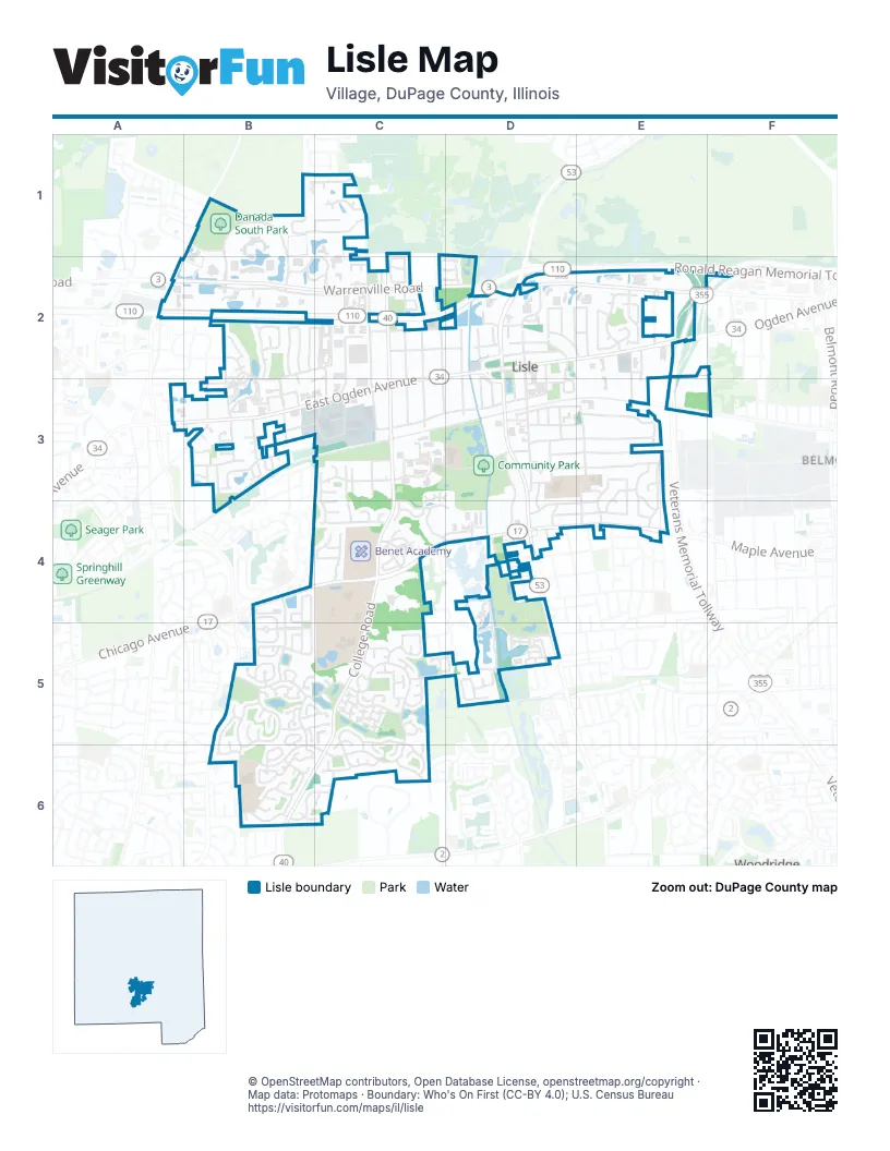
Street index of Lisle
Each street on the sheet and the grid squares it crosses.
- Ronald Reagan Memorial TollwayA2, B2, C2, D2
- Veterans Memorial TollwayE2, F2, E3
- East Ogden AvenueC2, D2, E2, B3, C3
- Lincoln AvenueD2, D3, D4
- Garfield AvenueD2, D3
- Maple AvenueB4, C4, D4, E4
- Warrenville RoadA2, B2, C2, D2, E2
- Yackley AvenueC2, C3, C4
- College RoadC4, C5, B6, C6
- Naperville RoadA2
- Burlington AvenueB3, C3, D3, F3
- Main StreetD2, D3
- Green Trails DriveB6, C6
- Abbeywood DriveB5, C5
- Lacey AvenueC2, D2, D3
- Kingston AvenueD2, E2, E3, E4
- Corporate West DriveB2, C2
- Middleton AvenueC2, D2
- Riverview DriveD3, D4
- Center AvenueD2, D3, D4
- Ohio StreetC3, E3
- Old Tavern RoadB2, C2, B3, C3
- Fender RoadB2, B3
- Front StreetD3, E3
- Four Lakes AvenueD5
- Leask LaneC1, C2
- Yender AvenueC2, C3
- Riedy RoadD3, E3
- Sun Valley RoadB6, C6
- Devon AvenueC2, C3
- Gamble DriveD3, E3
- Beau Bien BoulevardB2, B3
- Hitchcock AvenueC3, D3, E3
- Westview LaneE3, E4
- Pebble Creek DriveB1, C1
- Breckenridge RoadB6
- Short StreetC3, D3
- East Lake DriveD4, D5
- Winchester AvenueC2, C3
- International CircleB1
- River Bend DriveD5
- Cabot DriveC1, B2, C2
- River DriveD2, D3
- Inverness RoadD4, E4
- Benedictine ParkwayB4, B5
- Carriage Hill RoadC5, C6
- Golfview RoadC5, C6
- Oak Ridge WayB4, B5
- Schwartz AvenueC2, C3
- Radcliff RoadB3
- International DriveB1, B2
- Corporetum DriveD2
- Wellington AvenueB3, C3
- Trinity DriveC5
- Basswood DriveE2
- Fernwood DriveB6
- Rolling DriveD4, E4
- New Albany RoadB5, B6
- Hatch LaneE2
- Valley Forge RoadB5, B6
- Forest View RoadD4, D5
- Oldham AvenueA2, B2, D2, E2
- Oak Hill DriveC4
- Meadow LaneE3, E4
- Northwood AvenueB4, B5
- Molex DriveC3
- Dumoulin AvenueD2, D3
- Arbor View DriveE2
- Indiana AvenueC3
- Western AvenueC2, C3
- Robin LaneC4, D4
- Plank RoadB3
- Southport AvenueD2
- Lafond CircleD5
- Walnut AvenueF2, F3
- Handley DriveB3
- Meyer DriveE3, E4
- Millbridge LaneC5
- Timbertrails RoadC5, C6
- Division StreetD3, E3
- Kohley RoadD4
- Beau Monde BoulevardC2
- Black Partridge LaneB2
- Heritage LaneC5
- Lexington RoadB5, B6
- Normandy DriveB2, B3
- Surrey Ridge RoadB5
- Karns RoadB3
- Lake Trail DriveB2, B3
- Pennywood DriveC3, C4
- Beau Monde DriveC2
- Shabbona LaneB2
- Cascade DriveC4
- Chelsea AvenueE2
- Longview DriveB5
- Windsor DriveB5
- Larkspur LaneE3, E4
- Waubansie LaneB2, C2
- Coach House RoadB5, B6
- White Birch DriveC2, D2
- Burr Oak RoadC4, D4
- Ridgewood RoadC5, C6
- Ridgeland AvenueB3
- Brookwood RoadC5, D5
- Garden DriveB6
- Blackhawk LaneC2
- Regency Woods DriveB1, C1
- Bristol DriveB5
- Lake Shore DriveD5
- Wayfaring LaneB5
- Eisenhower LaneC4, D4
- Tyrnbury DriveB5
- Arbor Trail DriveB5
- Keller StreetB3
- Edgebrooke DriveC1
- Spencer AvenueD2, D3
- Buckingham DriveB4, B5
- Old College RoadC6
- Sleepy Hollow LaneC5
- Forbes DriveB1, B2
- Longwood DriveD5
- Saint Joseph Creek RoadE2, E3
- School StreetD3
- Stonehaven WayC5
- River RoadD4
- Rivers Edge DriveD5
- Ironwood LaneD5
- Jonquil AvenueD3, E3
- Retreat CircleB4, B5
- Essex RoadD4
- McKenzie Station DriveD3
- Mc Kinley AvenueD2, D3
- Portsmouth DriveC4
- Hidden Creek CourtC1
- Lake Valley DriveB2, B3
- Clover DriveE3, E4
- Jaeger LoopC4
- Cascara LaneE2
- Brittany DriveB2
- Greenfield DriveB6
- Illinois AvenueC3
- Subiaco DriveC4
- Columbia AvenueD3
- Auvergne AvenueE2, E3
- Tanglewood DriveC6
- Norcia DriveC4
- Yovonovitz LaneB2, C2
- Ranier DriveC4
- Burnham StreetB3
- Ashley CircleB3
- Scarlet Oak LaneC5
- Scott CircleB3
- Hawthorne LaneD3
- Spruce LaneE2
- Woodcliff CourtB5, C5
- Tangley Oaks TrailB3
- Kindling CourtC5
- Hastings LaneB5
- Middleton PlaceD2
- Monestary DriveC4
- Redwood LaneE2
- Old Oaks DriveB3
- Oakview DriveD3, D4
- Lenox RoadD4
- Parksleg CourtC5
- Pleasant Hill LaneC5
- Elm AvenueE2, E3
- Hill Trail RoadB3
- Twin Oaks LaneB5, C5
- Buckley RoadD2
- Cypress CourtC3
- Winstead CourtC5
- University LaneC3
- Tellis LaneC5
- Trowbridge WayC5
- Ivy DriveB5
- Pine RoadC2
- Yorkshire LaneB5
- Lakewood DriveB5
- Pruthmore CourtC5
- Pepper Tree CourtC5, C6
- Fiona LaneC2
- Shellingham DriveB5
- Santuary StreetB5
- Ashford CourtC5
- Dixon DriveC5, D5
- Black Oak DriveC2
- Lillian LaneC2
- Angel LaneC5
- Woodsbriar CourtC5
- Mark Carre CourtB3
- Bloomfield DriveB5, B6
- Keim RoadC2
- Lisle PlaceD3
- Varsity DriveC3
- Canterbury LaneC2
- Aspen RoadB6
- Stonebrook RoadB6
- Azalea DriveC2
- Normandy PlaceB2
- Holly CourtC5
- Newport DriveC4
- Shasta DriveC4
- Willow Glen CourtB3
- Cherry LaneC2
- Dogwood DriveC2
- Westerhoff DriveC2
- Nutmeg LaneC2
- Candlewood CourtC4
- Oakwood DriveD5
- Berkshire CourtB5
- White Oak LaneB5, C5
- Alta CourtB6, C6
- Tory CourtB5
- Saint Tropez PlaceB2
- Sailboat CoveB2, B3
- Ridge RoadB3
- Walnut Creek LaneE2, F2
- Fairway DriveD5
- Hillside LaneC5
- Burning Tree CourtC2, D2
- Ivanhoe AvenueE2
- Miller LaneC5
- Tall Tree CourtC4
- Timberview DriveC5
- Patton DriveD4
- Dorset AvenueD2
- Pine Tree CourtC2, D2
- Smith RoadD4
- Saint Tropez DriveB2
- Alma LaneC1
- Western CourtC2
- Deerpath CourtC5, C6
- Briarcliff CourtB5
- Hampshire CourtB5
- Beau Bien Lane WestB3
- Bella CourtB3
- Tealwood DriveB6
- Black Oak CourtC5
- Bluebell CourtE3
- Sunnydale LaneC5
- Weeping Willow DriveB5
- Academy DriveC3
- Acorn Hill CourtC5
- Bayside CourtC4
- Briggs CourtC5
- Chippewa CourtC2, B3, C3
- Barkridge CourtC3
- Torrey Pine LaneB5
- Adams DriveC4
- Westleigh CourtB5
- Saint Anton CourtB6
- Barnwall CourtC3
- High Pass LaneB3
- Matson LaneC2
- Innsbruck CourtB6
- Reidy PlaceD3
- Adler CourtC4
- Beau Bien Court EastB3
- Harth CourtC5
- Raintree CourtC5, C6
- Beau Bien Lane EastB3
- Morton RoadC2
- Camden CourtB5
- Lee CourtD5
- Taos CourtC6
- Wellington CourtC3
- Royal Glen CourtC5, C6
- Maurus CourtC4
- Ohio CourtC3
- Ory Bridge CourtC5
- Shorewood CourtC5
- Christian LaneC5
- Wingate DriveC5
- Lincoln PlaceD2
- Water Bridge RoadB2
- Bush StreetD2, E2
- Vail CourtB6
- Glenbrook CourtB5
- Burgundy PlaceB2
- Hanover CourtB5
- Red Oak LaneB1
- Vernon Park PlaceD3
- Parkview DriveC2
- Stefan CourtB3
- Driftwood CourtC4
- Collegewood CourtC6
- Beau Monde TerraceC2
- Cape Cod CourtB5, B6
- Placid CourtC4
- Bentley CourtB5
- Beau Monde LaneC2
- Wedgewood CourtB2, B3
- Shagbark CourtC6
- Hinterlong CourtC5
- Knollwood CourtB5
- Beau Bien Court WestB3
- Stowe CourtB6
- Venture StreetE3
- Commerce CourtB2
Places on the map
- 53 Touch-Free Car Wash
- Abbeywood Park
- Aldi
- Alexander Equipment Company
- American Commercial Bank & Trust
- Arbor View Park
- Arboretum Woods Park
- Aspen Park
- AutoZone
- Beau Bien Park
- Benedictine University
- Benedictine University Library
- Benet Academy
- Bill Kay Chevrolet
- Candlewood Park
- College Road Park
- Community Park
- Danada South Park
- Faith United Methodist Church
- Green Trails Shopping Center
- Hampshire Park
- Heritage Farms Ponds North
- Heritage Farms Ponds South
- Kennedy Junior High School
- Lake Saint Benedict
- Lisle High School
- Lisle Junior High School
- Maple Plaza
- Old Tavern Park
- Peach Creek Park
- River Bend Golf Club
- Surrey Ridge Park
- Surrey Ridge Sports Complex
- Tate Woods Park
- Tee Time
- The Sports Complex at Benedictine University
- The UPS Store
- Valley Forge Park
- Woodglenn Park
Next to Lisle
- Belmont
- Woodridge map
© OpenStreetMap contributors, Open Database License, openstreetmap.org/copyright · Map data: Protomaps · Boundary: Who's On First (CC-BY 4.0); U.S. Census Bureau















