

Illinois map
Woodridge map
About 34,103 people live here (Census Bureau, 2024 estimate). The sheet's index lists 300 streets; Veterans Memorial Tollway, Woodward Avenue and 75th Street cross the most grid squares. Also on it: Hawthorne Hill Woods, Main Street at Seven Bridges and Seven Bridges Golf Club.
Open the map (PDF, US Letter)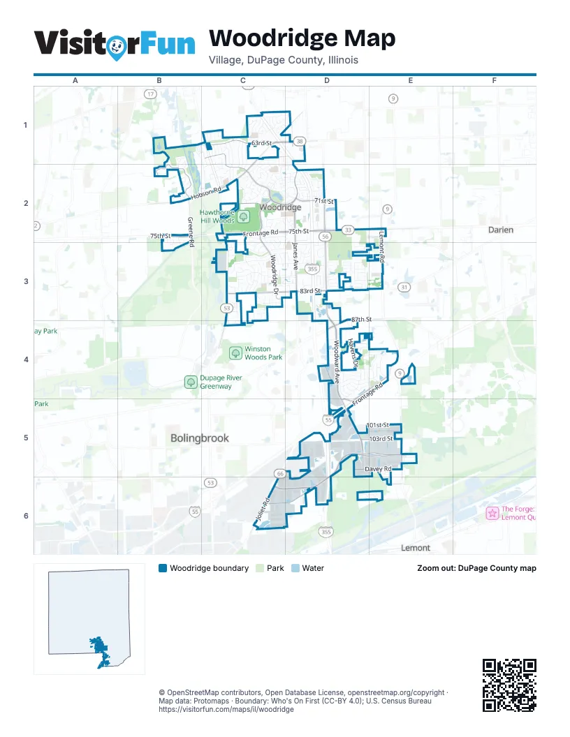
Street index of Woodridge
Each street on the sheet and the grid squares it crosses.
- Veterans Memorial TollwayC1, D1, D2, D3, D4, D5, D6
- Adlai Stevenson ExpresswayD4, E4, D5
- Lemont RoadE2, E3, E5
- Joliet RoadC6
- North Bolingbrook DriveC4
- Woodward AvenueD2, D3, D4, D5
- 75th StreetB2, C2, D2, E2
- Hobson RoadC1, D1, B2, C2
- 83rd StreetC3, D3
- 63rd StreetC1, D1
- 87th StreetD3, D4
- East Boughton RoadD4
- Internationale ParkwayD5, E5, C6, D6
- Woodridge DriveC1, C2, C3
- Janes AvenueD1, D2, D3
- Davey RoadD5, E5, C6, D6
- Greene RoadB2
- 71st StreetC2, D2
- Heritage ParkwayE4, D5
- 101st StreetD5, E5
- Center DriveC2, D2
- Murphy RoadD4, E5, E6
- 103rd StreetD5, E5
- Morey DriveD5
- 109th StreetE6
- Frontage RoadC2, D2
- South Frontage RoadD4, E4, D5
- Crabtree AvenueC3, D3
- Westview LaneC2, C3
- Everglade AvenueC3
- Double Eagle DriveB1, C2
- Hillcrest LaneD4, E4
- Jackson DriveC1, D1
- Mitchell DriveC1, C2
- Beaudin BoulevardD5, D6
- Jonquil LaneC3, D3
- Gloucester RoadD4, E4
- Westminster DriveD4, E4
- Forest Glen ParkwayC2, D2
- Dunham RoadD2, D3
- David DriveC3
- Catalpa AvenueC2, C3
- Roberts DriveC2
- Foxtree AvenueC2, D2
- Adam Don ParkwayD4, D5
- Meadowdale LaneC3, D3
- Werch DriveD5
- Meadowwood AvenueD3
- Sprucewood AvenueC2, C3
- Stonewall AvenueC1, D1
- Main StreetB1, C1, C2
- Edgewood ParkwayC3
- Havens DriveD3, D4
- Brunswick CircleC2, D2
- Janeswood DriveC2, D2
- Mending Wall DriveC3, C4
- Country Club DriveD3
- Dalewood ParkwayD3
- Gladstone DriveB2, B3
- Larchwood LaneC2, D2, D3
- Willow AvenueC2, C3
- Tower Hill DriveD4
- Chase AvenueD1
- South Witham LaneD4
- Golf View DriveD3
- Walnut AvenueC1, C2, C3
- Lancaster LaneD4
- Harcourt DriveD3
- Westmoreland DriveC2
- Middlebury AvenueD3
- Plaza DriveC2, D2
- Puffer RoadD1
- MacArthur DriveC1, C2
- Taylor DriveC1, C2
- Woodcrest DriveD4
- Maxwell DriveC1, C2
- Winston DriveC1, C2
- Foxridge CourtC3
- Bobby Jones LaneB1, B2
- Lamond AvenueC1
- Waterbury DriveC3, D3
- Paddington RoadD3
- Williams DriveC2
- Northcreek DriveC3
- Charing Cross RoadD4
- Talcott RoadD4
- Oak Bluff LaneD6, E6
- Forest DriveC3, D3
- Chesterton DriveD3
- Halsey DriveC1, C2
- Justamere RoadC3, C4
- Providence DriveD2
- Leawood LaneC3
- Deerfield AvenueD2, C3
- South Somerset LaneD4
- Martin DriveC2
- Marmon DriveD6
- Ide DriveD3
- Harvest AvenueD2
- Spring StreetC3, D3
- Yellow Star StreetC2
- Autumn DriveC3
- Ravinia LaneC2, D2
- Peters DriveD4
- Summerhill DriveC1
- Chick Evans LaneB2
- Wheeler StreetD2
- Katherines CrossingD6
- Wolfe DriveC1, D1
- Chauser LaneD4
- Oxford StreetD4
- Scenicwood LaneC3
- Charmingfare DriveD2
- Coppergate RoadE4
- Una AvenueC3
- Sherman DriveC1
- Two Paths DriveC3
- Argonne DriveE5
- Rutgers DriveD4
- Carolwood LaneC3
- Kincaid DriveC2
- Concord DriveC2, D2
- Huntleigh LaneC1, D1
- Wainwright DriveC2
- Cambridge RoadD2
- Geneva StreetC3
- Hawthorne AvenueD2
- Rutherford DriveD3
- Tyler DriveC1
- Patton DriveC2
- Adbeth AvenueC3
- Hastings RoadD4
- Ridgeway DriveC1
- Oakview LaneC3
- Birchwood ParkwayD3
- Danbury DriveC2, D2
- Parkside DriveC1
- Apache LaneD3
- Piers DriveD3
- Greenleaf StreetD2
- Wallace DriveD4
- Evergreen LaneD3
- Oak Tree TrailC1, C2
- Redwing DriveD2
- Nottingham RoadD3
- Deer StreetC3
- 76th StreetC3
- Chelsea LaneC3
- Christopher DriveE5, E6
- Green DriveC1
- Naples LaneE5
- Ross DriveC1
- Woodview DriveC2, C3
- Gatewood LaneC3
- Didrikson LaneB2
- Prairieview AvenueD2
- Carlton DriveC2, D2
- Eaton DriveD3
- Vista DriveD2
- Beller RoadD3
- 59th StreetC1, D1
- Cedar Hill LaneC1
- Hartford LaneD3
- Richfield CourtD3
- Westridge DriveC2, C3
- 64th StreetD1
- Bedford DriveD4
- Noble DriveC2
- Vardon CourtB2
- Sunnydale DriveD2
- Wintergreen CourtC2
- Marshall DriveC1
- Burr Ridge CourtC3
- Sunnydale StreetD2
- Brassie CourtB2, C2
- Linden CircleD6
- Mashie CourtB2, C2
- Hobson Valley DriveC2
- Witham LaneD4
- Dean DriveC1
- Harleyford RoadD4
- Wheatfield StreetC2, D2
- Clark DriveC1
- Butternut CourtC3
- Oakleaf DriveC3
- Vernon CourtC1
- Eastwood LaneC3
- Britten StreetD3
- Mulligan DriveB1, C1
- Longford StreetD3
- Ridge LaneD3
- Arnold DriveC1
- Basswood LaneD3
- Hobson Gate CourtB2
- Oldwoods DriveC3
- Stonebridge WayE5
- East 107th StreetD5
- High Trail DriveC1, C2
- Fox StreetC3
- Ice Arena DriveC2
- Bradley DriveC1
- Stansted RoadD4
- Sheridan DriveC1
- Stillwell CourtC2
- Creek DriveB2
- Green Trails DriveB2
- Valley View LaneD3
- Kildeer StreetD2
- Lindenwood LaneC3
- North Somerset LaneD4
- Beller DriveD3
- Chestnut AvenueD3
- Yorkshire DriveD2
- Chippingham RoadD3
- Buckingham CircleD2
- Perry DriveC1
- Mourning Dove CourtD3
- Emerald CourtD3
- Hickory CourtC3
- Lee StreetC1
- Goldfinch StreetD2
- Thames DriveD4
- Apple LaneD2
- Cedar DriveD3
- Edgewood DriveD3
- Keswick DriveD4
- Duke StreetD4
- Audubon AvenueD2
- Kelly DriveC3, D3
- Seven Bridges DriveC2
- Mohawk AvenueC2, D2
- Hampton DriveD3
- Sun Drop AvenueC2
- Scarlet Hawthorn CourtC2, D2
- Egerton DriveD3
- Leonard AvenueD1
- Saratoga AvenueE4
- Allan DriveC1
- Ridgestone DriveB2, B3
- Sumac StreetC2
- Pine DriveD3
- Mulberry DriveD3
- Foxboro DriveC3
- Meyer RoadC1
- Wallace WayD5
- Cambridge LaneD2
- Fir LaneD3
- Compton RoadD3
- Sundowner RoadC1
- Andrea DriveC3
- Fringetree LaneD3
- Stable RoadC1
- Zurich CourtC3
- Balsam LaneD3
- Anchor DriveD3
- Cromwell AvenueD3
- Crystal CourtC3, D3
- Laura LaneE5
- Wild Plum StreetC2
- Zurich LaneC3
- Canterbury LaneC3
- Fitzgerald RoadD2
- Armstrong CourtC2
- Dogwood DriveD3
- Argonne Woods DriveE5
- Young CourtC2
- Wellington RoadD3
- Mansfield StreetD3
- Woodlyn DriveD3
- Redcliffe StreetD3
- Summerall DriveC1
- Joann LaneC3
- Bristol CourtD2, D3
- Middlecoff CourtB2
- Rothenburg RoadE5
- Blue Flag AvenueC2
- Cobb DriveD4
- Chelsea DriveC3
- Snead CourtB1, B2
- Whitney LaneE6
- Orchard LaneD2, D3
- Cherry Tree AvenueC2
- Carpenter CourtC2
- Lakeview CourtC2
- Clover LaneD4
- Shagbark CourtC3, C4
- Alexander DriveE5
- Wilton LaneD2
- Norwood CourtC3
- Pheasant StreetD2
- Prairie LaneD4
- Diamond CourtC1, C2
- Westbury DriveD3
- Whispering Oaks CourtC3
- Leander CourtC1, D1
- Rosebury AvenueD3
- Sioux AvenueD2
- Bluff RoadE6
- Davos AvenueC3
- Oakville StreetD4
Places on the map
- 63rd Street Park
- Arby's
- ARC - Athletic Recreational Center
- ARC Soccer Fields
- Art Van Furniture
- Ascension Health
- Bakers Square
- Bank of America
- Bear Paddle Swim School
- Boundary Hill Woods
- BP Shop
- Castaldo Park
- Centerpointe
- Crabtree Park
- Cypress Cove
- Edgewood Elementary School
- Eighty-Third Street Park
- Fox Hollow Forest Preserve
- Goodrich Elementary School
- Hawthorne Hill Woods
- Hobson Corner Park
- Ide's Grove West Park
- Janes Avenue Park
- Lake Carleton
- Lake Carleton Park
- Lake Harriet Park
- Main Street at Seven Bridges
- Meadowview Elementary School
- Mending Wall Park
- Orchard Hill Park
- Rutgers Park
- Seven Bridges Golf Club
- Summerhill Park
- Sunnydale Park
- Village Greens of Woodridge
- Vincente Natural Area
- Westminster Park
- Woodgrove Festival
- Woodridge Baptist Church
Next to Woodridge
© OpenStreetMap contributors, Open Database License, openstreetmap.org/copyright · Map data: Protomaps · Boundary: Who's On First (CC-BY 4.0); U.S. Census Bureau















