

Illinois map
Lockport map
About 26,915 people live here (Census Bureau, 2024 estimate). The sheet's index lists 300 streets; Veterans Memorial Tollway, South Archer Avenue and East Division Street cross the most grid squares. Also on it: Broken Arrow Golf Club, Dellwood Park and Legacy Adventure Park.
Open the map (PDF, US Letter)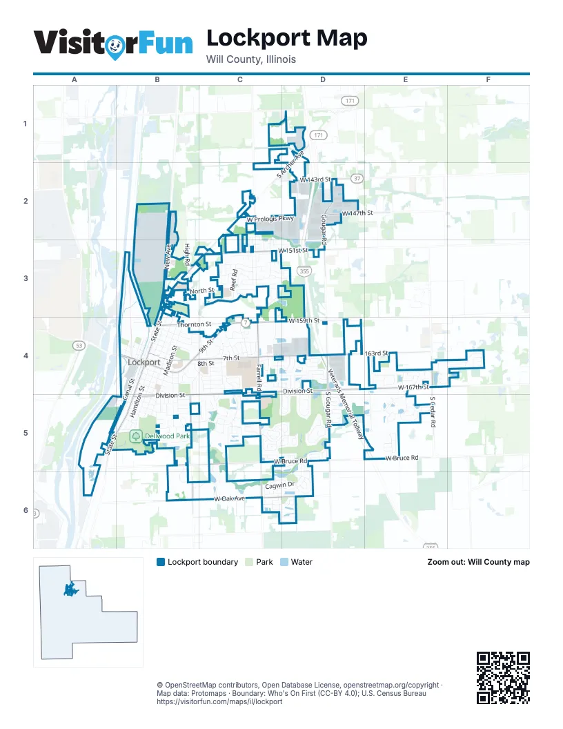
Street index of Lockport
Each street on the sheet and the grid squares it crosses.
- Veterans Memorial TollwayD2, D3, D4, D5, E5
- South State StreetB4, A5, B5
- South Archer AvenueD1, C2, B3, C3
- North State StreetB3, B4
- East 9th StreetB4, C4
- New AvenueB2, B3
- West 159th StreetC4, D4
- West 9th StreetB4
- West 143rd StreetD2
- East Division StreetC4, D4, B5, C5
- East 7th StreetB4, C4, D4
- South Farrell RoadC4, C5, C6
- West Bruce RoadB5, C5, D5, E5
- West 167th StreetD4, E4
- West 151st StreetC3, D3
- South Gougar RoadD3, D4, D5
- West Oak AvenueB6, C6, D6
- Gougar RoadD2, D3
- 163rd StreetD4, E4
- South Briggs StreetB5, B6
- South Cedar RoadE4, E5
- West 147th StreetC2, D2
- Thornton StreetB4, C4
- Farrell RoadC6
- Lemont RoadD2
- Smith RoadC2
- South Hamilton StreetB4, B5
- Lago Vista BoulevardC4, B5, C5
- West Prologis ParkwayC2, D2
- South Jefferson StreetB4, B5
- Canal StreetB4, B5
- North Farrell RoadC2, C3, C4
- Washington StreetB4, B5
- Madison StreetB4, B5
- North StreetB3, C3
- Read StreetC4
- Summit DriveC4, C5
- Cagwin DriveD5, C6, D6
- Daviess AvenueB4, B5
- East 11th StreetB4
- East 8th StreetB4, C4
- East 3rd StreetB4, C4
- Prime Business LoopE4, E5
- Broken Arrow DriveC5, D5
- West Oneida DriveC5, D5
- MacGregor RoadC3
- West Victoria CrossingE4, F4
- Blackfoot DriveD4, D5
- East 2nd StreetB4, C4
- Milne DriveC4
- West Deerwood DriveC6, D6
- Spring View DriveC4, D4
- Sprucewood DriveE5
- Parkview LaneB5
- Fox Hollow DriveB6, C6
- Geneva AvenueC5, C6
- Alta DriveD6
- East 12th StreetB4
- Lawrence AvenueB5
- Sterling DriveD1, B5
- West Apache DriveC5, D5
- Village LaneB5, B6
- Cedar Ridge DriveE4, E5
- Swift Arrow DriveD4, D5
- East 17th StreetB5
- East 4th StreetB4
- East 13th StreetB4, B5
- Runyan DriveC4
- East 10th StreetB4
- South StreetB5
- Key West DriveC3
- West Pennyroyal LaneD4
- High RoadB3
- Reef RoadC3
- West Blackhawk DriveD5
- East 6th StreetB4
- Grandview AvenueB4, B5
- Melbourne PlaceF4
- Lanfear DriveC6, D6
- South Washington StreetB4
- South Mitchell LaneC6, D6
- Peachtree LaneC5
- South Hillside DriveC3, D3
- Ames StreetB4
- East StreetB5
- Willow Walk DriveC5, D5
- Cove AvenueC3
- Valley LaneB4, C4
- Ashton LaneE5
- Pinewood RoadE5
- Lakeside DriveC4, D4
- Magnolia DriveC5
- Ottawa DriveD4, D5
- Golf View DriveD5
- Prodehl DriveC4
- Pioneer ParkwayD4
- Long Meadow DriveE4
- East 18th StreetB5
- Austin DriveE5
- Tralee LaneC3
- Merc LaneC3
- South Douglas ParkwayC3
- Adelmann DriveC4
- Northern DriveB3, C3
- South Preserve DriveC2, C3
- Lincoln StreetB4, B5
- Sagebrook DriveD4
- West Division StreetA5, B5
- East Woods LaneA5, B5
- Darin DriveC4
- Mohican DriveD5
- South Lakeview DriveC4
- Mendota DriveC5
- Seneca DriveC5
- South Morel StreetD4, D5
- High Meadow DriveD4
- Dell Park AvenueA5, B5
- Watters DriveC6, D6
- Clinton StreetB4
- West Red Cloud DriveD5
- Dorchester PlaceE4, F4
- West Huntington DriveC3
- Highland AvenueC3
- West McKenzie AvenueC3
- West 2nd StreetB4
- Garfield AvenueB4, B5
- Wheatgrass StreetE4
- East 16th StreetB5
- McCabe LaneC6
- East 5th StreetB4
- Victoria LaneE5
- Amelia CircleE5
- Saddlewood DriveC3
- East 14th StreetB4, B5
- West Cottonwood DriveC6, D6
- Gilbert DriveD5, D6
- Mead StreetC5
- Etchingham DriveF4
- Ash LaneC4, D4
- West Primrose LaneC3, D3
- Collingwood DriveC3
- Como AvenueC5
- North Glenmore StreetC3
- Old Canal RoadA5
- Maitland DriveC4
- Ennerdale AvenueC5
- Jaquays StreetC4
- Putnam DriveC4
- West Summerwind DriveE4
- Saint Charles DriveC4
- Golden Valley LaneC3, D3
- Commerce StreetB4
- East Wellwood DriveC3
- Karen Springs DriveC4
- Westwood DriveC4
- Split Rail DriveC4, D4
- South Windsor LaneE4
- Washburn WayC4
- East 15th StreetB4, B5
- Austrian Pine StreetB5
- South Sun Meadow DriveE4
- Olympic LaneC3
- Bunratty DriveC2, C3
- Downing StreetF4
- Roosevelt AvenueC5
- West Iroquois DriveD5
- Newbridge DriveC3
- Balaton DriveC5
- Rosanne StreetB5
- Tonelli TrailC4
- Burton AvenueC5
- Montauk DriveC5, D5
- Lacoma CourtC4
- Lisdowney DriveC3
- East 19th StreetB5
- West Adobe DriveC5
- Table StreetB3
- Le Jeune AvenueC4
- Neuberry Ridge DriveB5
- Adams StreetB4, C4
- Natoma DriveC5
- Canterbury WayF4
- Wilker DriveB5
- Lone Star DriveB5
- Carriage StationF4
- Sisson StreetB5
- West 8th StreetB4
- East Parkview LaneB5
- Willard LaneD6
- Holly CourtC4
- South Orchid LaneD5
- Maple CourtC4
- South Sunset Ridge CourtD4, D5
- Clover Ridge DriveC4
- South Madison StreetB5
- Eastlake ParkwayE4
- Lacoma DriveC4
- Lorraine CourtB5
- West 7th StreetB4
- West Sioux DriveC5
- Auburn Ridge DriveB5
- West Abbey LaneE4
- Shoals DriveC3
- Shawnee DriveD4, D5
- Treeline CourtC3
- South Coventry LaneE4
- West 6th StreetB4
- West StreetB3, B5
- Albright DriveE5
- Arbor TerraceC3, D3
- Katherine StreetB4, C4
- West Keswick PlaceE4
- Burch DriveD4
- West 163rd StreetF4
- West Coneflower DriveD4
- Erie LaneC5
- Basil DriveC6
- Wirestem DriveD4
- North Hamilton StreetB3, B4
- Lilac LaneD5
- Delaware DriveC5, D5
- Illini DriveC4
- Daggett StreetB5
- Pine AvenueA5
- Cleveland StreetB4, B5
- Longbow DriveD5
- East Dunslow LaneC3
- Janice AvenueB5
- South Rowley LaneC4
- West McDonald DriveC3
- South Creighton DriveE5
- Argo LaneC4
- Deer Run DriveD4
- Lane DriveD4
- Pinecreek DriveD4
- Mitchell LaneC6
- Hedgewood DriveB5
- Teton DriveD5
- 141st StreetD1
- Franklin StreetB3, B4
- Stephanie DriveC4
- Bonneville StreetB5, C5
- Red Bud LaneC3
- Will DriveC4
- Delavan AvenueC5
- Muehl StreetB4
- North Washington StreetB3, B4
- Weis LaneC4
- South Parker Ridge DriveD4, D5
- Ashley Court SouthC4
- East Treeline DriveC3
- South Silo Bend DriveE4
- Mary Ann LaneB5
- Charleston CircleC5
- Sand Lilly StreetD4
- South Hunters WayC3
- Illinois LaneE5
- Richton DriveE5
- Foxford LaneC3
- Basin DriveC3
- Rodney StreetC4
- West Grace StreetC4
- West Harvest LaneE4
- Boehme StreetB5
- Quail Ridge DriveB5
- Fontana LaneC5
- Morgan StreetB3
- Case DriveD4
- South Winding Creek LaneE4
- Vine StreetB4
- Edgewood DriveD3
- Porter PlaceC4
- North Jefferson StreetB3, B4
- Rhonda DriveC4
- Melville CourtC5
- Winnipeg CircleC5
- Aston WayE4, F4
- Connor StreetB5
- Wall StreetE5
- Carlislie LaneC5
- Fieldstone PlaceC4
- Gloria StreetB4, C4
- Aster DriveD5
- Ashley Court NorthC4
- McKinley StreetB4
- Prairie AvenueA5, B5
- West Switch Grass DriveD4
- South Basham DriveD2
- South Oak Run CourtC3
- Arrowhead DriveD5
- Placid CourtC5
- South Sequoia WayB5
- Connor AvenueB5
- West Turnberry CircleD6
- Bent Grass DriveD5
- Fern DriveD5
- Newcastle WayE4
- Courtside DriveC4, D4
- Strawberry Hill DriveC4, C5
- White Tail WayC2, C3
Places on the map
- Aldi
- Berkot's Super Foods
- Bettenhausen Chrysler Dodge Jeep RAM
- Bo Jacksons Elite Sports
- Broken Arrow Golf Club
- Burger King
- Cafeteria
- Calvary Cemetery
- Cedar Park
- Challenge Fitness / Lockport Twp. Park District
- Chase
- Clover Ridge Plaza
- Community Life Church
- Culver's
- CVS Pharmacy
- Dellwood Park
- Dellwood Park Community Center (DPCC)
- Downtown Lockport
- Drake Commons
- Dreams
- Embers Tap House
- First Congregational Church
- First United Methodist Church of Lockport
- Gaylord Building
- Legacy Adventure Park
- Lockport Cemetery
- Lockport Post Office
- Lockport Praire East Preserve
- Lockport Township High School - East Campus
- Ludwig Elementary School
- Milne Grove Elementary School
- Regency Point
- Runyon County Forest Preserve
- Saint Pauls Lutheran Church
- Summit Plaza
- UPS Lockport Customer Center
- Victoria Pond
- Walmart Supercenter
- Walsh Elementary School
- Willow Walk Park
© OpenStreetMap contributors, Open Database License, openstreetmap.org/copyright · Map data: Protomaps · Boundary: Who's On First (CC-BY 4.0); U.S. Census Bureau















