

Illinois map
Maywood map
About 23,364 people live here (Census Bureau, 2024 estimate). The sheet's index lists 94 streets; South 9th Avenue, 21st Avenue and South 10th Avenue cross the most grid squares. Also on it: Greenwood Transfer Facility, Maywood Grove Preserve and Maywood Park.
Open the map (PDF, US Letter)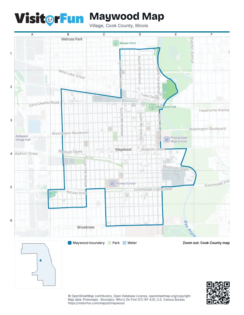
Street index of Maywood
Each street on the sheet and the grid squares it crosses.
- Augusta StreetC1, D1
- Hugh Muir LaneC1, D1
- North 9th AvenueC1, C2
- Rice StreetC1, D1
- 1st AvenueD1
- Nichols LaneD1
- North 1st AvenueD1, E1, E2
- North 2nd AvenueD1, D2
- North 3rd AvenueD1, D2
- North 4th AvenueD1, D2
- North 5th AvenueD1, D2
- North 6th AvenueD1, D2
- North 7th AvenueD1, D2
- North 8th AvenueD1, D2
- Walton StreetD1
- 21st AvenueB2, B3, B4, B5, B6
- Broadway AvenueB2
- Railroad AvenueB2, C2
- Saint Charles RoadB2, C2, D2
- South 17th AvenueB2, B3, B4, B5
- South 18th AvenueB2, B3, B4, B5
- South 19th AvenueB2, B3, B4, B5
- South 20th AvenueB2, B3, B4, B5
- Chicago AvenueC2, D2, E2
- Huron StreetC2, D2, E2
- Lake StreetC2, D2, E2
- Main StreetC2, D2, E2
- South 10th AvenueC2, C3, C4, C5, C6
- South 11th AvenueC2, C3, C4, C5, C6
- South 12th AvenueC2, C3, C4, C5, C6
- South 13th AvenueC2, C3, C4, C5
- South 14th AvenueC2, C3, C4, C5
- South 15th AvenueC2, C3, C4, C5
- South 16th AvenueC2, C3, C4, C5
- South 9th AvenueC2, C3, D3, D4, D5, D6
- Superior StreetC2, D2, E2
- West Lake StreetC2
- Erie StreetD2, E2
- Ohio StreetD2, E2
- South 5th AvenueD2, D3, D4, D5, D6
- South 6th AvenueD2, D3, D4, D5, D6
- South 7th AvenueD2, D3, D4, D5, D6
- South 8th AvenueD2, D3, D4, D5, D6
- Anna StreetE2
- Des Plaines AvenueE2
- Maywood Grove Access RoadE2
- South 1st AvenueE2, E3, E4, E5, E6
- Oak StreetB3, C3, D3
- Randolph StreetB3, C3, D3
- Washington BoulevardB3, C3, D3
- Maple StreetC3, D3
- Pine StreetC3, D3
- Walnut StreetC3, D3
- South 2nd AvenueD3, D4, D5, D6, E6
- South 3rd AvenueD3, D4, D5, D6
- South 4th AvenueD3, D4, D5, D6
- Madison StreetB4, C4, D4, E4
- Maywood DriveB4
- North Maywood DriveB4, C4, D4
- South 21st AvenueB4, B5
- South Maywood DriveB4, C4
- Warren AvenueB4, C4
- Adams StreetC4, D4, B5
- School StreetC4, D4, E4
- Warren StreetC4, D4
- Green StreetD4, E4
- Legion StreetD4, E4
- Wilcox StreetD4, E4
- Greenwood AvenueE4
- Maybrook DriveE4
- Orchard AvenueE4
- Eisenhower ExpresswayA5, B5, C5, D5, E5
- South 25th AvenueA5
- 18th AvenueB5, B6
- 19th AvenueB5, B6
- 20th AvenueB5, B6
- 22nd AvenueB5, B6
- 23rd AvenueB5, B6
- 24th AvenueB5, B6
- Bataan DriveB5, C5, D5, E5
- Harrison StreetB5, C5, D5, E5
- Lexington StreetB5, C5, D5
- Van Buren StreetB5, C5, D5, E5
- 13th AvenueC5, C6
- 17th AvenueC5
- Quincy StreetC5, D5, E5
- Congress StreetD5, E5
- 11th AvenueC6
- 12th AvenueC6
- Fillmore StreetC6, D6, E6
- Harvard StreetC6, D6
- Roosevelt RoadC6, D6
- Fearns DriveD6
- Hines BoulevardD6
Places on the map
- AmeriCash Loans
- AutoZone
- Burger King
- Christ Temple Church
- Citgo
- Cook County Maybrook Courthouse
- Cook County Sheriff's Police
- CubeSmart
- Emerson Elementary School
- Emmanuel Evangelical Lutheran Church
- Family Aquatic Center
- Family Dollar
- First Baptist Church
- First Christian Church
- First Congregational Church
- Forest Preserve District of Cook County
- Garfield Elementary School
- God's Heritage Full Gospel Church
- Good Shepherd Church of God
- Greenwood Transfer Facility
- Irving Middle School
- James Memorial African Methodist Episcopal Church
- Life Harvest Christian Center
- Lincoln Elementary School
- Maywood Fine Arts
- Maywood Grove Preserve
- Maywood Park
- Maywood Police Deptartment
- Maywood Post Office
- Maywood Public Library
- Maywood Public Library Annex
- Maywood Supportive Living
- Maywood Village Hall
- Maywood Village Recreation
- Maywood Village Recreation (annex)
- McDonald's
- Memorial Park
- Neighborhood United Methodist Church
- New Beginnings Christian Fellowship
- Proviso School
Next to Maywood
- Broadview
- Melrose Park map
© OpenStreetMap contributors, Open Database License, openstreetmap.org/copyright · Map data: Protomaps · Boundary: Who's On First (CC-BY 4.0); U.S. Census Bureau















