

Illinois map
Northlake map
About 12,433 people live here (Census Bureau, 2024 estimate). The sheet's index lists 120 streets; Tri-State Tollway, East Belle Drive and North Wolf Road cross the most grid squares. Also on it: Fairview Memorial Park, AF Truck Center and Centerpoint Preserve & Recreational Facility.
Open the map (PDF, US Letter)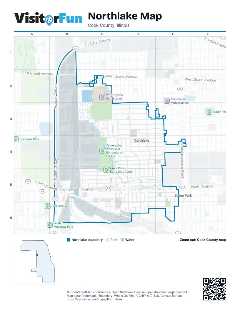
Street index of Northlake
Each street on the sheet and the grid squares it crosses.
- Garnet DriveB1, B2
- O'Hare West BypassB1
- Tri-State TollwayB1, B2, B3, B4, B5, B6
- Northwest AvenueB2, B3
- West Grand AvenueB2, C2
- Derrough AvenueC2
- Diversey AvenueC2
- Diversey ParkwayC2
- Marian AvenueC2
- Martin AvenueC2
- North Wolf RoadC2, C3, C4, C5
- Rhodes AvenueC2
- Sandra AvenueC2
- Winters DriveC2
- North Roberta AvenueD2, D3, D4, D5
- Wrightwood AvenueD2
- North King Arthur CourtB3, C3
- North Northwest AvenueB3, B4, B5
- North Railroad AvenueB3, B4, B5
- East Dewey AvenueC3, D3, E3
- East Fullerton AvenueC3, D3, E3
- East Hayes DriveC3, D3
- East Lyndale AvenueC3, D3, E3
- East MacArthur DriveC3, D3
- East Medill AvenueC3, D3, E3
- Laporte AvenueC3, C4
- North Jerome DriveC3, C4
- North Lavergne AvenueC3, C4, C5
- North Sandra AvenueC3
- Wagner DriveC3, D3
- West Fullerton AvenueC3, E3
- West Longfield AvenueC3
- Altgeld StreetD3
- Landen DriveD3
- Melrose AvenueD3, E3
- North Roy AvenueD3, D4, D5
- Geneva AvenueE3
- Lyndale AvenueE3
- Montana AvenueE3
- North Geneva AvenueE3, E4
- Champion WayB4, C4
- County Line RoadB4, B5
- Whitehall DriveB4, C4, D4, E4
- Automatic Electric DriveC4
- East Armitage AvenueC4, D4, E4
- East Bernice AvenueC4, D4, E4
- East Palmer AvenueC4, D4, E4
- Village DriveC4, D4, E4
- West Palmer AvenueC4, E4
- East Belle DriveD4, E4, C5, D5, E5
- East Dickens AvenueD4, E4
- East Major DriveD4, E4
- North Haber CourtD4
- North McLean AvenueD4
- North Prater AvenueD4, D5
- Williams DrD4, D5
- Dickens AvenueE4
- Fred Paul CourtE4, E5
- North Alvin AvenueE4, E5
- North Mannheim RoadE4
- 47th AvenueB5, B6
- Ashbel AvenueB5
- East North AvenueB5, C5, D5, E5
- Frontage RoadB5
- South Railroad AvenueB5
- West DriveB5, C5
- West Franklin DriveB5, C5
- West Golfview DriveB5, C5
- West Lake StreetB5, C6
- West North AvenueB5, C5
- Westward Ho DriveB5, C5
- Doyle DriveC5
- East Country Club DriveC5, D5, E5
- East DriveC5, D5
- East Lemoyne StreetC5, D5
- East Park View DriveC5, D5, E5
- East Wiltse ParkwayC5, D5
- Elm AvenueC5
- Lind AvenueC5, C6
- North AvenueC5, D5, E5
- North Harvard AvenueC5
- North Hillside AvenueC5
- South Gail AvenueC5, D5
- South Wolf RoadC5, C6
- West Lemoyne StreetC5
- East Charles DriveD5
- East Le Moyne AvenueD5, E5
- East Morse AvenueD5, E5
- North Caryl AvenueD5
- North Harold AvenueD5
- North Marilyn AvenueD5
- South Caryl AvenueD5, D6
- South Dodd AvenueD5, D6
- South Harold AvenueD5, D6
- South Marilyn AvenueD5, D6
- South Prater AvenueD5, D6
- South Roberta AvenueD5, D6
- South Roy AvenueD5, D6
- 45th AvenueE5, E6
- North Edward AvenueE5
- South 44th AvenueE5, E6
- South 46th AvenueE5, E6
- East Lake StreetC6, D6
- Hillside AvenueC6
- Lakewood TerraceC6, D6
- Lavergne AvenueC6
- South Elm AvenueC6
- South Elm StreetC6
- South Lavergne AvenueC6
- West Soffel AvenueC6
- East Hirsch AvenueD6, E6
- East Victoria DriveD6, E6
- South Lakewood AvenueD6
- South Maplewood AvenueD6
- 43rd AvenueE6
- 44th AvenueE6
- Division StreetE6
- East Soffel AvenueE6
- Hirsch StreetE6
- West Hirsch AvenueE6
Places on the map
- AF Diesel
- AF Truck Center
- Aldi
- AutoZone
- Bethel Fellowship Church
- Centerpoint Preserve & Recreational Facility
- Concord Palace Retirement And Assisted Living
- Creekside Park
- Fairview Memorial Park
- Friendly Park
- Grant Park Recreation Center
- Kindred Hospital Chicago Northlake
- McDonald's
- Meineke
- Northlake American Legion Hall
- Northlake City Hall
- Northlake Commons Shopping Center
- Northlake Dog Park
- Northlake Park
- Northlake Police Department
- Northlake Post Office
- Northlake Public Library
- Portillo's
- Roy Elementary School
- Saint John the Baptist Melkite Catholic Church
- Saint John Vianney Church
- Saint Peters Syrian Orthodox Church
- Sam's Club
- Shell
- Sherwin-Williams
- Speedway
- Super 8 by Wyndham Chicago Northlake O'Hare South
- The Home Depot
- Trinity Presbyterian Church
- U.S. Bank
- Walgreens
- Walmart
- West Leyden High School
- Westdale Elementary School
Next to Northlake
- Stone Park
© OpenStreetMap contributors, Open Database License, openstreetmap.org/copyright · Map data: Protomaps · Boundary: Who's On First (CC-BY 4.0); U.S. Census Bureau















