

Illinois map
Prospect Heights map
About 15,566 people live here (Census Bureau, 2024 estimate). The sheet's index lists 232 streets; East Stonegate Drive, North Elmhurst Road and Palatine Road cross the most grid squares. Also on it: Allison Woods, Allison Woods Preserve and Rob Roy Golf Club.
Open the map (PDF, US Letter)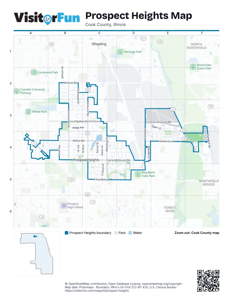
Street index of Prospect Heights
Each street on the sheet and the grid squares it crosses.
- Abourndale CourtB2
- Cherry Creek LaneB2
- Creekside CourtB2
- East Stonegate DriveB2, C2, B3, C3
- Garden CourtB2
- Garden LaneB2
- Harbour DriveB2
- Jackson DriveB2
- Kerry CourtB2
- Longtree DriveB2
- Lynnbrook DriveB2, C2
- Meadow Ridge LaneB2
- North Cornell AvenueB2
- North Highland DriveB2
- PeriwinkleB2
- Pin Oak LaneB2
- Prairie CircleB2
- Schoenbeck RoadB2, B3, B4
- Sherwood DriveB2, B3
- South Cornell AvenueB2
- Stonegate Drive WestB2
- Twilight LaneB2
- Walden LaneB2, B3
- West Hintz RoadB2, C2
- West Stonegate DriveB2, B3
- Wildwood Drive NorthB2, C2
- Wildwood Drive WestB2, B3
- Woodview DriveB2
- Drake TerraceC2
- Eleanor DriveC2
- Forums CourtC2, C3
- Maple LaneC2
- North Elmhurst RoadC2, C3, C4, C5
- Oak AvenueC2
- Pleasant Run DriveC2, C3
- Prospect DriveC2
- Rose LaneC2
- South Elmhurst RoadC2
- Wildwood Drive EastC2, C3
- Andover DriveB3, C3
- Anne CourtB3
- Cresthill DriveB3
- Derbyshire CourtB3
- Derbyshire LaneB3
- Elm StreetB3, B4
- Essex StreetB3, C3
- Glenbrook DriveB3, C3
- Oakwood DriveB3, C3
- Palatine RoadB3, C3, D3, E3
- Ridge AvenueB3, C3
- Tomah AvenueB3, B4
- Viola LaneB3
- West Kenilworth AvenueB3, C3
- Wildwood Drive SouthB3, C3
- Andover CourtC3
- Carl CourtC3, C4
- Countryside LaneC3
- Creek CourtC3
- East Kenilworth AvenueC3, C4
- Equestrian DriveC3
- Glendale DriveC3
- Kenneth AvenueC3
- North Maple StreetC3, C4
- North School StreetC3
- North Wheeling RoadC3, C4, C5
- Robert AvenueC3
- Spruce DriveC3
- Waltz CourtC3
- Pinecrest RoadD3, E3
- Piper LaneD3, E3
- South Wolf RoadD3, D4, D5
- West Messner DriveD3
- West Palatine RoadD3, E3
- Apple DriveE3
- Blossom LaneE3, E4
- Burning Bush DriveE3, E4
- Cider LaneE3, E4
- Crimson CourtE3, E4
- East Palatine RoadE3
- Love DriveE3
- Milwaukee AvenueE3, E4, F4
- Pinecrest DriveE3
- Plaza DriveE3
- South Milwaukee AvenueE3
- Tree LaneE3, E4
- Wimbleton DriveE3
- Carlyle CourtA4
- Center LaneA4
- East Oakton StreetA4
- East Olive StreetA4, B4
- East Rand RoadA4
- East Thomas StreetA4
- Forrest AvenueA4
- Linden Road NorthA4
- Linden Road SouthA4
- North Drury LaneA4
- North Phelps AvenueA4
- North Stratford RoadA4
- North Windsor DriveA4
- William's WayA4
- Dale AvenueB4
- Dorset StreetB4
- East Circle AvenueB4
- Etowah AvenueB4
- Frankie CourtB4
- Gail Court NorthB4
- Gail Court SouthB4
- Kewaunee CourtB4
- Lancaster AvenueB4
- Manor AvenueB4
- Marion StreetB4, C4
- Minnaqua DriveB4
- Nawata PlaceB4
- North ParkwayB4, C4
- North Waterman AvenueB4
- Prospect CourtB4
- Royal CourtB4
- South ParkwayB4, C4
- West Camp McDonald RoadB4, C4
- West Circle AvenueB4
- West Clarendon StreetB4
- West Marion StreetB4
- West Olive AvenueB4, C4
- West Willow RoadB4, C4
- Brian LaneC4
- Casa CourtC4
- Claire LaneC4, D4
- Country Club DriveC4, D4, C5, D5
- East Camp McDonald RoadC4, D4
- East Clarendon StreetC4
- East Leon LaneC4
- East Marion AvenueC4
- East Olive AvenueC4
- East Willow RoadC4
- Grego CourtC4, D4
- Hill CourtC4
- Hillcrest DriveC4
- Hillside AvenueC4
- Leon LaneC4
- Lewis Isle LaneC4, C5
- Maple AvenueC4
- Marberry DriveC4, C5
- Owen CourtC4
- Owen StreetC4
- Pine StreetC4
- Rob Roy LaneC4, C5, D5
- Robyn CourtC4
- School StreetC4
- Shawn LaneC4, D4
- South Maple LaneC4, C5
- South Owen PlaceC4, C5
- South Wheeling RoadC4, C5
- Thierry LaneC4
- West Leon LaneC4
- Alderman AvenueD4
- Alderman LaneD4
- Alton RoadD4, D5
- Bonnie Brook DriveD4
- Coldren LaneD4
- East Elaine CircleD4
- East Maya LaneD4
- Elaine CircleD4
- Galway DriveD4
- Mandel LaneD4
- Mohawk LaneD4
- Newcastle LaneD4
- Old Willow RoadD4
- Patricia LaneD4
- Riley AvenueD4
- Roberts LaneD4
- Rose AvenueD4
- Seminole LaneD4, E4
- Shannon DriveD4
- Waterford DriveD4
- West Elaine CircleD4
- Willow RoadD4
- Cove DriveE4
- Crabapple DriveE4
- Jonathan CourtE4
- McIntosh CourtE4
- North Andoa LaneE4
- North Mura LaneE4
- North River RoadE4, F4
- Park DriveE4
- Quaker LaneE4
- Shoehonee TrailE4
- Winesap CourtE4
- Crowne Plaza HotelF4
- Sanders RoadF4
- Vogay LaneF4
- Winkelman RoadF4
- Aberdeen LaneC5
- Brook RoadC5
- Chester LaneC5
- Compton LaneC5
- Concord WayC5, D5
- East Euclid AvenueC5
- East School LaneC5
- Edinburg LaneC5, D5
- Ferndale CourtC5
- Ferndale LaneC5
- Green Bridge LaneC5
- Greystone LaneC5
- Grove PlaceC5
- Hawthorne PlaceC5
- Kingsmill LaneC5
- Lanford LaneC5
- Loch Lomond LaneC5
- Lonsdale RoadC5
- Mars PlaceC5
- Owen PlaceC5
- South School LaneC5
- Sutherland LaneC5
- Thistle LaneC5, D5
- Tully PlaceC5
- Williamsburg LaneC5
- Burr Oak LaneD5
- Edward Cul de Sac StreetD5
- Edward RoadD5
- Fairway CourtD5
- Fairway DriveD5
- Glasgow LaneD5
- Golf View CircleD5
- Margate LaneD5
- Mulberry LaneD5
- Newgate LaneD5
- Pembridge LaneD5
- Pine Forest LaneD5
- Regent LaneD5
- Stirling LaneD5
- Sussex Corner LaneD5
- Willow Hills LaneD5
Places on the map
- 34 Pad
- Aldi
- Allison Woods
- Allison Woods Preserve
- Area 2
- Area 3
- Chase
- Citgo
- Country Garden Park
- Crowne Plaza Chicago-Northbrook
- Fries Automotive Services
- Fry the Coop
- Hangar 1
- Hangar 11
- Hangar 5
- Hangar 50
- Hangar 51
- Hangar 6
- Hangar 7
- Hangar 8
- Hawthorne Global Aviation Services
- Hebron Presbyterian Church
- Hilton Chicago/Northbrook
- Holiday Inn Express & Suites Prospect Heights
- Indian Trails Library District Branch
- Isaak Walton Park
- John Muir Park
- Kiwanis Park
- Lions Park
- Lutheran Church of the Good Shepherd
- Marathon
- McDonald's
- Mobil
- Motel 6 Prospect Heights
- Patriots Park
- Pauwaukee Plaza
- Preiser Animal Hospital
- Rob Roy Golf Club
- Wheeling Township
- Willow Trails Park
Next to Prospect Heights
- Forest River
- North Northfield
- Northfield Woods
- Wheeling map
© OpenStreetMap contributors, Open Database License, openstreetmap.org/copyright · Map data: Protomaps · Boundary: Who's On First (CC-BY 4.0); U.S. Census Bureau















