

Illinois map
Rolling Meadows map
About 23,732 people live here (Census Bureau, 2024 estimate). The sheet's index lists 300 streets; Jane Addams Memorial Tollway, West Algonquin Road and Kirchoff Road cross the most grid squares. Also on it: Kimball Hill Park, Marketplace and Meadows Crossing.
Open the map (PDF, US Letter)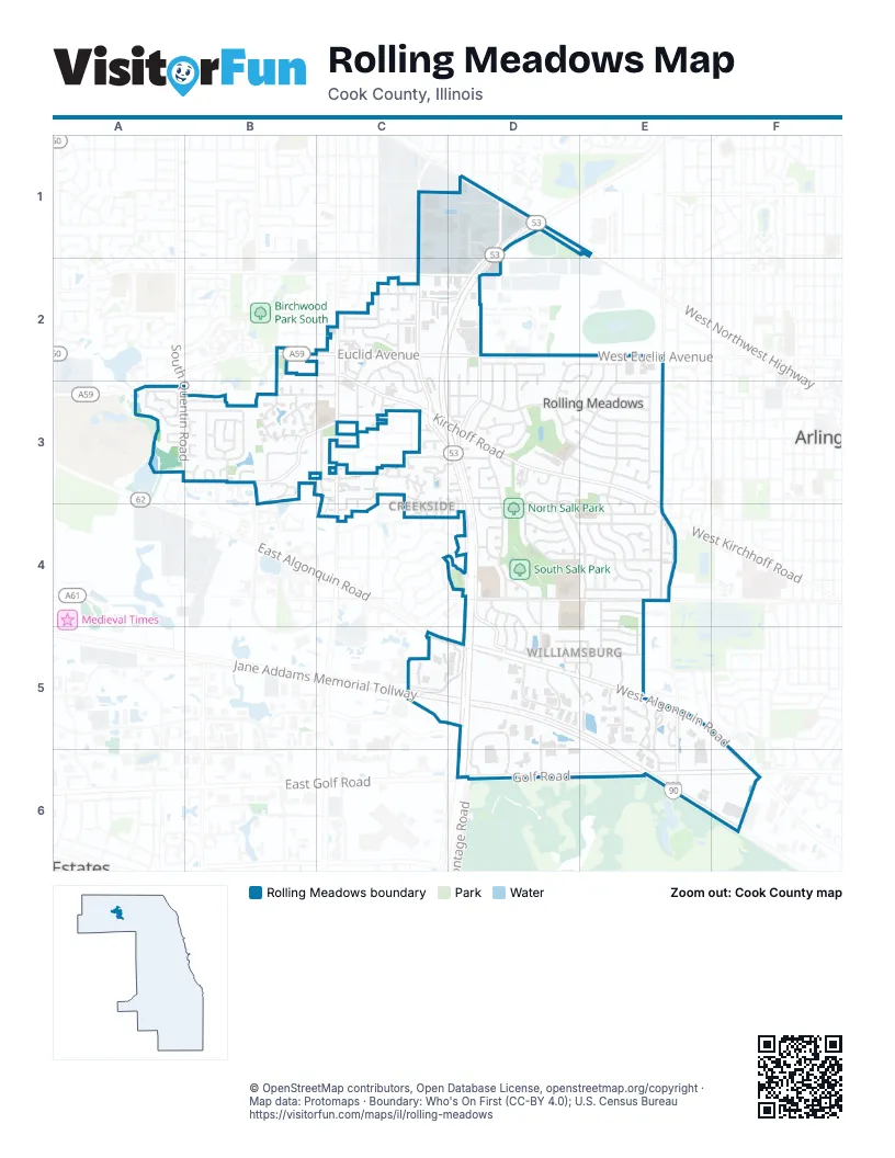
Street index of Rolling Meadows
Each street on the sheet and the grid squares it crosses.
- Jane Addams Memorial TollwayC5, D5, E5, E6, F6
- Golf RoadD6, E6, F6
- West Algonquin RoadC5, D5, E5, F5, F6
- East Frontage RoadD3, D4, D5, D6
- East Golf RoadD6
- West Golf RoadF6
- Kirchoff RoadC2, C3, D3, E3, E4
- Rohlwing RoadD1, D2, D3
- West Frontage RoadC3, D3, D4
- West Euclid AvenueB2, C2, D2, E2
- Hicks RoadC1, C2, C3
- South Plum Grove RoadC2, B3, C3
- South Wilke RoadE3, E4
- Euclid AvenueC2, D2
- New Wilke RoadE4
- South Meacham RoadC3, C4
- South Quentin RoadA3
- South New Wilke RoadE4, E5, E6
- North Wilke RoadE2, E3
- Industrial AvenueC2, D2
- West Central RoadE4
- South Hicks RoadC2
- West Kirchhoff RoadE4
- Central RoadD4, E4
- Magnolia DriveD4, D5
- Old Plum Grove RoadB3, C3
- Winnetka AvenueC2, D2
- Plum Grove DriveD5
- Sycamore LaneD4, D5
- Hartung RoadB3
- Weber DriveE4, E5
- Meadow DriveD3, E3, D4
- Campbell StreetD3, E3
- Arbor DriveC5, D5
- Ring RoadD5, D6
- Owl DriveD3, D4
- Oriole LaneE3, E4
- Dove StreetE3, E4
- Bluebird LaneE2, E3, E4
- Wren LaneE2, E3, E4
- Sigwalt StreetD3, E3
- Fremont StreetD2, E2
- Hawk LaneD3, D4, E4
- Jay LaneE2, D3, D4, E4
- Highland DriveA3, B3
- California AvenueC2, C3
- Grouse LaneD4, E4
- Vermont StreetC2, C3
- Commuter DriveD1
- Cardinal DriveD2, D3
- Martin LaneD3, D4, E4
- Saint James StreetD2, E2, D3, E3
- Carriageway DriveD5, E5
- School DriveD2, D3
- Brockway StreetC2, C3
- Pheasant DriveD3, D4
- Plum Tree LaneB3
- Park StreetD3, E3
- Flicker LaneD2, D3
- West Emerson AvenueB3, C3
- South StreetD3, E3
- Dawngate LaneC3
- Brookmeade DriveD4, D5
- Tollview DriveD5
- Lincoln AvenueC2
- East Oaksbury LaneC3
- Arlingdale DriveA3, B3
- George StreetE3
- Barker AvenueD4, D5
- Fulle StreetE4
- OxfordC2
- Peacock LaneD4
- Algonquin ParkwayE5
- West Dupont AvenueB2, C2
- Lois DriveE5, E6
- Silent Brook LaneA3, B3
- Gallagher WayD6
- Thrush LaneD4
- Smith StreetB3
- Elizabeth PlaceE5
- Wilson AvenueC2, C3
- Benton StreetC3
- Astor LaneE5, E6
- Arrowwood LaneB3
- Town Square DriveD3
- Crestwood DriveC3, C4
- Squibb AvenueD5
- Linden LaneE4, E5
- Pebble Brook LaneB3
- Wing StreetE3
- East Wilmette AvenueC2
- Mill Creek LaneB3
- Creekside DriveD3, C4
- Oak LaneE5
- Meadowbrook Industrial CourtE5
- Newport DriveD5
- Robin LaneD2, D3
- East Kingfisher LaneE3, E4
- Deerfield LaneB3
- Brookwood Way DriveC3
- Hoover StreetC2
- Prairie LaneA3
- Birch LaneE5
- Cedar StreetE4
- Forest AvenueD2, D3
- Eastman StreetE3
- Apollo DriveD5, D6
- Berdnick StreetD1
- East Fairfax AvenueC3
- Carnegie StreetD1, D2
- Adams StreetC2, C3
- Teonia Woods RoadC3
- Meijer DriveF6
- Starling LaneD4
- Yarrow LaneB3, C3
- Swallow LaneD4
- Bobwhite LaneD4
- Bobolink LaneD3, D4
- South Brockway StreetC2
- South Smith StreetB2
- Willow LaneE5
- Owl LaneD3
- Ashland AvenueD2, D3
- Thorntree LaneD4, D5
- Gettysburg DriveC2
- Eagle LaneE4
- Kings Walk DriveC2
- Northampton DriveD5, E5
- Auburn DriveC3
- Orchard DriveD5
- West Sunset DriveB3
- Groveside LaneB3
- Emerson AvenueD3
- Asbury StreetC3
- Grove RoadB3
- Old Mill LaneB3
- Raven LaneE4
- Villa Circle DriveB3
- Jody CourtC3
- Killarney CourtE4
- Kingfisher LaneD3
- Holly LaneD3
- Brookview LaneB3
- Lexington LaneD3
- Tinder DriveE5
- Quail LaneE4
- DuxburyC2, C3
- Taft AvenueC2
- St George DriveC3
- Bent Creek CourtB3
- Theda LaneD2, D3
- Auburn StreetC3, D3
- West Campbell StreetE3
- Tall Oaks LaneC3
- Honeysuckle CourtB3
- Edgar StreetC3
- Edison PlaceD1
- Meadow LaneD4
- Attleboro on AuburnC3
- Millstone LaneB3
- Southampton DriveD5, E5
- Fox LaneB3
- Kimberly AvenueC3
- Park DriveD4
- Library RoadD3
- Geranium WayD3, E3
- Essex WayD5
- St Colette RoadD4
- Kenilworth DriveD5
- Woodcliff LaneC3, C4
- Mayflower CourtE5
- Deep Woods LaneC3
- South Corona DriveA3
- Calvert DriveE5
- South Vermont StreetB3
- Chapman CourtC3
- Honeysuckle LaneB3
- Rumford on AsburyC3
- Oaksberry CourtC3
- Blackhawk DriveD1
- Carr StreetE5
- Falcon Court SouthD3
- Falcon Court WestD3
- Greenwich CourtC3
- Kimball Hill DriveE5
- College CrossingA3, B3
- Golf PlaceE6
- West Stonegate BoulevardD2
- North Corona DriveA3
- Winnetka CircleC2
- Ashley CourtD3
- Fairfax AvenueD3
- New Castle CourtB3
- Lavender CourtE5
- Hawthorne LaneD4
- Keystone CourtE5
- Williamsburg CourtC3
- Maple LaneE4
- Iris AvenueD3, E3
- Wellington CourtD3
- Heather CourtB3
- Mallard CourtD4
- Meadowbrook CourtE5
- Chas DriveC3
- Plum Blossom TrailB3
- Bridgeton on AsburyC3
- Mayberry CourtB3
- Chateau DriveE5
- Hampton on AuburnC3
- Walnut CourtD3
- Garfield AvenueC3
- Woods Chapel RoadD3, D4
- Ironwood CourtB3
- Shagbark RoadD3, D4
- Knoll Ridge RoadC3, C4
- Wildwood RoadC3
- Kevin LaneB3
- Rosewood RoadC3
- Tory LaneC2, C3
- Park CourtE3
- Stork CourtD3
- Norwood CourtB3
- Grove StreetE3
- Balmoral CourtD3
- Buckingham CourtA3, B3
- Walden Office SquareC5
- Amanda CourtB3
- George CourtD3, E3
- Crane CourtE4
- Old Hickory RoadC3, C4
- Falcon Court NorthD3
- Finch CourtD3
- New Bridge CourtB3
- Davis CourtC2
- Woodbine RoadC3, C4
- West Miner StreetE3
- Sunset CourtB3
- Farmington CourtB3
- Cyndi CourtE4
- Lilac CourtB3
- South CourtE3
- Stacy CourtB3
- Viola CourtB3
- Dogwood RoadC3
- Fieldstone RoadC4
- Spruce CourtD3
- Colleen CourtC3
- Eleanore CourtD3
- Mallory CourtB3
- Rywick DriveD3
- Butterfield CourtB3
- Dahlia CourtB3
- Gull CourtE4
- Maple CourtE4, E5
- Burning Tree RoadC3, C4
- Chicory CourtB3
- Denny CourtC2
- Juniper RoadC3
- Lark CourtD2
- Rhiannon CourtC2
- Swan LaneD2
- Bob White CourtD4
- Castle LaneB3
- Crossing CourtB3
- Heron CourtD2, D3
- Piper CourtD4
- Marilyn CourtC2
- Stoneridge RoadC3
- Tern CourtD3
- Greenwood CourtB3
- Teal CourtD4
- Wren CourtE4
- Mc Kone CourtC3
- Falkirk LaneC3
- Shady CourtC3
- Tall Trees CourtC3
- Dove CourtE3
- Peacock CourtD4
- Alexandra CourtC3
- Bryant AvenueC2
- Dawngate CourtC3
- Old Valley RoadC4
- Kimberry CourtB3
- Lisa CourtB3
- Kingfisher CourtE3, E4
- Oak Creek RoadC4
- Woodcliff CourtC4
- Amaarja CourtC3
- Richnee LaneC3, C4
- Quail CourtE4
- Thrush CourtD4
- Debra CourtD3
- Grouse CourtD4
- Jonquil CourtB3
- Edgewood CourtB3
- Ginger CourtB3
- West Salt Creek LaneD2
- Azalea CourtE5
- Jasmine LaneB3
- Sigwalt CourtD3
Places on the map
- Amoco
- BMO
- Carl Sandburg Middle School
- Carriageway Drive
- Central Road Elementary School
- Chase
- Chef Ping
- Community Church of Rolling Meadows
- Cook County Rolling Meadows Courthouse
- Coquelicot Gallery and Cafe
- Countryside Park
- CVS Pharmacy
- Driven Car Wash
- Dunkin'
- Edgewood Pond
- Express Automotive
- Extended Stay America - Chicago - Rolling Meadows
- FedEx Office
- Fifth Third Bank
- Gallagher Way
- Harvest Bible Chapel
- Holiday Inn Express Rolling Mdws-Schaumburg Area
- Honey Berry Cafe
- Huntington Bank
- Jewel-Osco
- Jimmy John's
- John G. Conyers Learning Academy
- Kimball Hill Elementary School
- Kimball Hill Park
- Los Laureles
- Marketplace
- Meadows Crossing
- Meijer
- North Salk Park
- Plum Grove Middle School
- Rolling Meadows High School
- Saint Colette School
- South Salk Park
- The UPS Store
© OpenStreetMap contributors, Open Database License, openstreetmap.org/copyright · Map data: Protomaps · Boundary: Who's On First (CC-BY 4.0); U.S. Census Bureau















