

Illinois map
Sterling Township map
About 14,535 people live here (Census Bureau, 2024 estimate). The sheet's index lists 249 streets; Hickory Hills Road, 6th Avenue and Freeport Road cross the most grid squares. Also on it: Sinnissippi Park, CGH Medical Center and Northland Mall.
Open the map (PDF, US Letter)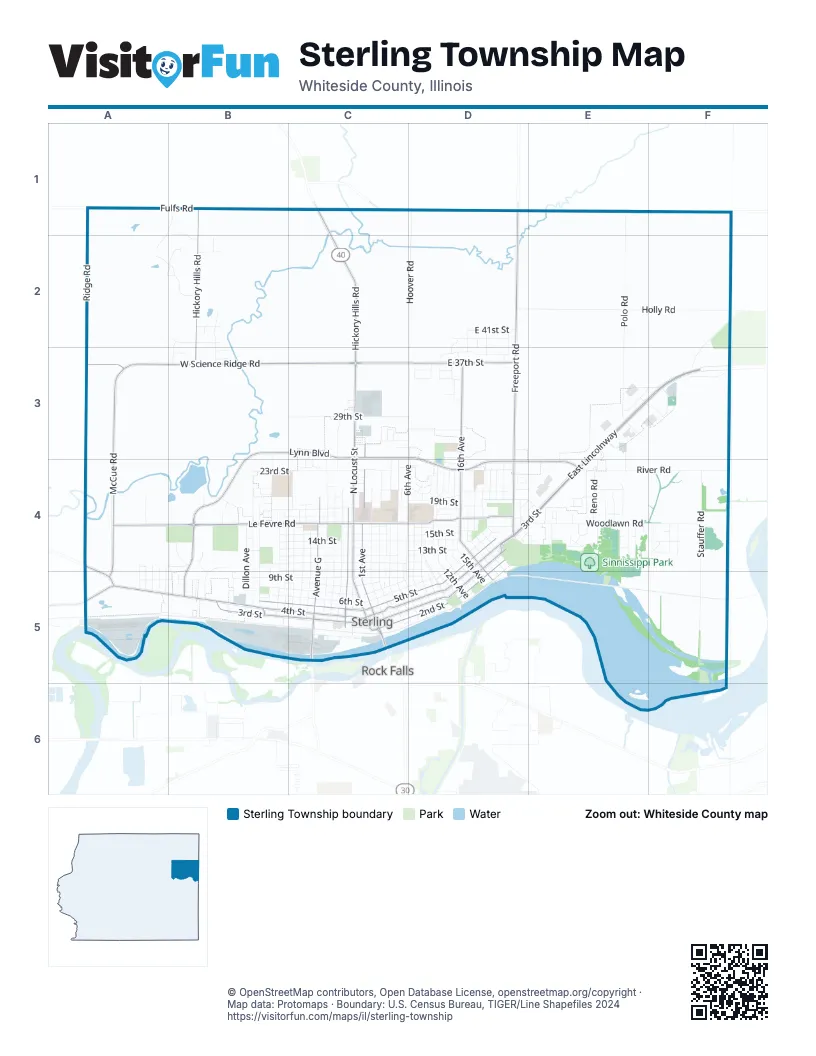
Street index of Sterling Township
Each street on the sheet and the grid squares it crosses.
- Grandview DriveA1, B1, A2
- Fulfs RoadB1, C1
- Hickory Hills RoadB1, C1, B2, C2, B3, C3
- Willow Creek RoadB1, B2
- Freeport RoadD1, D2, D3, D4
- Hoover RoadD1, D2, D3
- Polo RoadE1, E2, E3
- Ridge RoadA2, A3
- Timber DriveA2, B2
- Hillcrest LaneB2, B3
- Hubbard StreetB2
- J StreetB2
- Meadows DriveB2
- Noel CourtB2
- Pine Hill RoadB2, B3
- R StreetB2
- 15th AvenueD2, D3, D4, D5
- 19th AvenueD2, D3, D4
- 21st AvenueD2, D3, D4
- 22nd AvenueD2, D3, D4
- 40th StreetD2
- East 39th StreetD2, D3
- East 40th StreetD2
- East 41st StreetD2
- Holly RoadD2, E2, F2
- Jenny CourtD2
- Palmyra RoadF2
- Prairieville RoadF2, F3
- McCue RoadA3, A4, A5
- West Science Ridge RoadA3, B3, C3
- Maddens DriveB3
- Oak Grove AvenueB3, B4
- Pleasant Hill DriveB3
- Spencer DriveB3
- West 29th StreetB3, C3
- West Lynn BoulevardB3, C3, B4
- 1st AvenueC3, C4, C5
- 27th StreetC3, D3
- 4th AvenueC3, C4, C5
- 5th AvenueC3, C4, C5, D5
- 6th AvenueC3, D3, C4, C5, D5
- Avenue EC3, C4, C5
- Clover LaneC3
- East 25th StreetC3, D3
- East 26th StreetC3, D3
- East 29th StreetC3, D3
- East Folkers RoadC3
- East Lynn BoulevardC3, D3, D4, E4
- Florence LaneC3, C4
- Katey CourtC3
- Meadow DriveC3
- Meadow LaneC3
- Megan CourtC3
- North Locust StreetC3, C4, C5
- Science Ridge RoadC3, D3
- Strotton DriveC3, C4
- 12th AvenueD3, D4, D5
- 14th AvenueD3, D4, D5
- 16th AvenueD3, D4, D5
- 24th PlaceD3
- 33rd StreetD3
- 7th AvenueD3, D4, D5
- 9th AvenueD3, D4, D5
- Candlelight LaneD3
- Country LaneD3
- East 28th StreetD3
- East 35th StreetD3
- East 36th StreetD3
- East 37th StreetD3
- East 38th StreetD3
- Heritage LaneD3
- Sunflower CourtD3
- 31st AvenueE3, E4
- 35th AvenueE3, E4
- 43rd AvenueE3, F3
- East 30th StreetE3, F3
- East LincolnwayE3, F3, D4, E4
- John Wayne RoadE3, E4
- 45th AvenueF3
- Country Club LaneF3
- 11th StreetA4
- Ash AvenueA4, A5
- East AvenueA4, B4, A5
- Elm AvenueA4, A5
- Emerson RoadA4, A5
- Fisher StreetA4
- Oak AvenueA4, A5
- West AvenueA4, A5
- West Le Fevre RoadA4, B4, C4
- Westwood DriveA4
- Annabelle LaneB4
- Avenue KB4, B5
- Avenue LB4, B5
- Chestnut AvenueB4
- Commerce DriveB4, B5
- Dillon AvenueB4, B5
- Douglas DriveB4, B5
- Eastwood DriveB4
- Enterprise DriveB4, B5
- Griswold AvenueB4, B5
- Harvey DriveB4
- Hickory RoadB4
- Industrial DriveB4
- North Lynn BoulevardB4
- Plant DriveB4
- South Lynn BoulevardB4, B5
- Strawberry LaneB4
- West 10th StreetB4, C4
- West 11th StreetB4, C4
- West 12th StreetB4, C4
- West 13th StreetB4, C4
- West 14th StreetB4, C4
- West 15th StreetB4, C4
- West 16th StreetB4, C4
- West 18th StreetB4, C4
- West 19th StreetB4, C4
- West 20th StreetB4, C4
- West 21st StreetB4, C4
- West 23rd StreetB4, C4
- Woodburn AvenueB4, B5
- Woodside AvenueB4
- Yost CourtB4, B5
- 21st StreetC4, D4
- 2nd AvenueC4, C5
- 3rd AvenueC4, C5
- Avenue CC4, C5
- Avenue DC4, C5
- Avenue FC4, C5
- Avenue GC4, C5
- Avenue HC4, C5
- Avenue IC4, C5
- Avenue JC4, C5
- Bushman AvenueC4
- Coventry CourtC4
- Coventry LaneC4
- East 10th StreetC4, D4, E4
- East 11th StreetC4, D4
- East 12th StreetC4, D4
- East 13th StreetC4, D4, E4
- East 14th StreetC4, D4
- East 15th StreetC4, D4
- East 16th StreetC4, D4
- East 19th StreetC4, D4, E4
- East 22nd PlaceC4
- East 23rd StreetC4, D4
- East Le Fevre RoadC4, D4
- East Miller RoadC4
- Greenridge DriveC4, D4
- Grobe RoadC4, D4
- Johnson AvenueC4, C5
- Reins StreetC4
- Saint Josephs StreetC4
- Shinkle AvenueC4
- Thome DriveC4
- Village LaneC4
- Walnut StreetC4
- West Miller RoadC4
- Wilson AvenueC4, C5
- 10th AvenueD4, D5
- 11th AvenueD4, D5
- 13th AvenueD4, D5
- 17th AvenueD4, D5
- 17th PlaceD4
- 18th AvenueD4
- 18th PlaceD4
- 20th AvenueD4
- 8th AvenueD4, D5
- Asbury AvenueD4
- Broadway AvenueD4, D5
- Calvary CourtD4
- Crandall StreetD4, E4
- East 18th StreetD4, E4
- East 1st StreetD4, C5, D5
- East 20th StreetD4, E4
- East 21st PlaceD4
- East 24th StreetD4
- East 2nd StreetD4, C5, D5
- East 3rd StreetD4, E4, C5, D5
- East 4th StreetD4, C5, D5
- East 5th StreetD4, C5, D5
- East 6th StreetD4, C5, D5
- East 7th StreetD4, C5
- Ellen WayD4
- Elm CourtD4
- Green CourtD4
- Leewayne Plaza RoadD4
- Long CourtD4
- Merrill StreetD4, E4
- North StreetD4
- Northland Park DriveD4
- Park DriveD4, E4
- Sanborn StreetD4, E4
- Spring StreetD4
- Waters CourtD4
- Windsor RoadD4, E4
- 19th StreetE4
- 29th PlaceE4
- 32nd AvenueE4
- 33rd AvenueE4
- 37th AvenueE4
- 38th AvenueE4
- 39th AvenueE4
- Bradley CourtE4
- East 17th StreetE4
- East 41st AvenueE4
- East Fortieth AvenueE4
- Mineral Springs RoadE4
- Parkview RoadE4
- Pinewood DriveE4
- Reno RoadE4
- River Ridge RoadE4
- River RoadE4, F4
- Sinnissippi Park RoadE4
- Susan CourtE4, F4
- Timberlane DriveE4
- Woodlawn RoadE4, F4
- Austin RoadF4
- Farley RoadF4
- Gregdon Shores RoadF4
- Margaret CourtF4
- Stauffer RoadF4, F5
- Weaver RoadF4
- Winn RoadF4
- West 4th StreetA5, B5, C5
- West 9th StreetA5, B5, C5
- West LincolnwayA5
- Avenue MB5
- Dixon CourtB5
- Maple LaneB5
- Prosperity DriveB5
- Wallace StreetB5, C5
- West 3rd StreetB5, C5
- West 5th StreetB5, C5
- West 6th StreetB5, C5
- West 7th StreetB5, C5
- West 8th StreetB5, C5
- A AvenueC5
- Avenue BC5
- BassC5
- East 8th StreetC5
- East 9th StreetC5, D5
- Light StreetC5
- Locust StreetC5
- Miller StreetC5
- Park AvenueC5
- Park PlaceC5
- Pike StreetC5
- West 2nd StreetC5
- Stouffer RoadF5
Places on the map
- 16th Ave Church of Christ
- Abiding Word Church
- ALDI
- AMC Classic Sauk Valley 8
- Arthur's Garden Deli
- Ashley HomeStore
- Bethel Reformed Church
- Blain's Farm & Fleet
- BP Shop
- Buffalo Wild Wings
- Calvary Cemetery
- Central Memorial Park
- CGH Lynn Blvd Medical Center
- CGH Medical Center
- Challand Middle School
- Christ Lutheran School
- County Market
- Crescent Electric Supply
- D & E Furniture
- Dillon Home
- Eberly Park
- Gartner Park
- Hoover Park
- Jefferson Elementary School
- Kilgour Park
- Menards
- Northland Mall
- Oppold Marina
- Peabody's Inc
- Platt Park
- Riverside Cemetery
- Rock River Trail
- Scheid Park
- Sinnissippi Park
- Sterling Crossing
- Sterling High School
- Thomas Park
- Walmart Supercenter
- Westwood Fitness & Sports Center
Next to Sterling Township
- Rock Falls
© OpenStreetMap contributors, Open Database License, openstreetmap.org/copyright · Map data: Protomaps · Boundary: U.S. Census Bureau, TIGER/Line Shapefiles 2024















