

Indiana map
Clarksville map
About 22,041 people live here (Census Bureau, 2024 estimate). The sheet's index lists 300 streets; Rosewood Drive, Blackiston Mill Road and County Line Road cross the most grid squares. Things to do inside the boundary: Falls of the Ohio State Park.
Open the map (PDF, US Letter)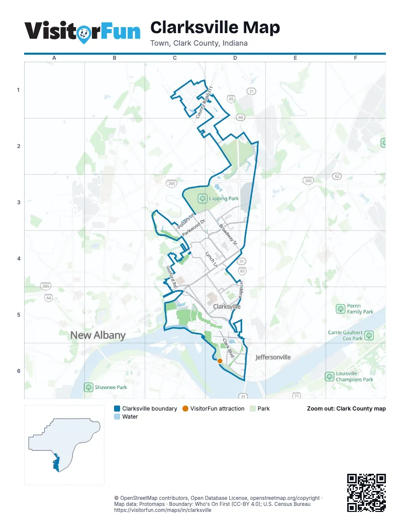
Street index of Clarksville
Each street on the sheet and the grid squares it crosses.
- Brown's Station WayC5, D5
- East Lewis and Clark ParkwayC4, D4
- West Lewis and Clark ParkwayC4, C5
- McCullough PikeC5
- County Road 311C1, D1
- Veterans ParkwayD3, D4
- Blackiston Mill RoadC3, C4, D4
- Greentree BoulevardD3, D4
- Eastern BoulevardD4, D5
- Broadway StreetD3, D4
- Potters LaneC3, D3
- State Road 60C1, D1
- Greentree NorthD3
- Armed Forces WayD3
- Blackiston Mill Road BrdigeC3
- Hamburg PikeD2
- Charlestown New Albany RoadD4
- South Clark BoulevardD5, D6
- North Clark BoulevardC5, D5
- Progress WayD3
- Kopp LaneD4, D5
- County Line RoadC1, C2, D2
- Lombardy DriveC3, C4, D4
- East Stansifer AvenueD5
- South Sherwood AvenueD5, D6
- Marlowe DriveC4
- Little League BoulevardD4, D5
- Gutford RoadC4, C5
- East Montgomery AvenueD6
- Providence WayC4, C5
- East Riverside DriveD6
- East Water StreetD2
- Stansifer AvenueD5
- Lincoln DriveC4, C5
- Payne-Koehler RoadD2
- Sam Gwin DriveD3
- Appleleaf LaneD2
- Applegate LaneD4
- Bowne BoulevardD5
- Byron DriveC4, D4
- Owens WayD5
- East Bowne BoulevardD5
- West 14th StreetD5
- Gulford RoadC4
- Court AvenueD6
- West Market StreetD6
- Corurt AvenueD6
- Addmore LaneD3
- Harrison AvenueC5, D5
- Randolph AvenueC5, D5
- Spicewood DriveC3, D3, C4
- Emery CrossingC5
- Parkwood DriveC3, D3, C4
- Lynch LaneC4, D4
- North Taggart AvenueC5, D5
- Mc Kinley AvenueC5, D5
- Hunter Station RoadC1, D1
- Bass Pro DriveD4
- Ashley's PlaceD4
- Wellington Green DriveD3
- Plum Creek DriveC1
- Thames DriveC4, D4
- North Sherwood AvenueD5
- Redwood DriveC3, D3, C4
- Cedar StreetD4
- Blackiston View DriveC4, D4
- Altawood DriveC4, D4
- Tennyson DriveC4
- Taylor DriveC4
- Beechlawn DriveC4
- Longfield DriveD4, D5
- Francis AvenueC5, D5
- Meyer LoopD1
- Evergreen DriveD4, D5
- Newman AvenueD5, D6
- Pacific DriveD3
- Longfellow DriveC4, D4
- Lincoln LaneD4
- Briarwood DriveC4
- Rosewood DriveD2, D3, C4, C5
- Kilmer WayC4
- Idlewood DriveC4
- Birch DriveC3, C4
- Marriott DriveD5, D6
- Twinbrook DriveC1
- Deer Run DriveD2
- Plum Woods DriveC1
- Cottonwood DriveC3, D3
- Plum RunC1
- Westmont DriveC1, D1
- West Kenwood AvenueC5, D5
- Johnson LaneC4
- Woodstock DriveD4
- Mc Tavish DriveC4
- Horn StreetD4
- Elmwood DriveC4
- West Howard AvenueD5
- Silver Lakes DriveD2
- Irving DriveD4
- Deatrick DriveD3
- Hazelwood DriveC3, D3
- Kensington DriveD4
- Clevidence BoulevardD3, D4
- West Riverside DriveD6
- Lindsay's PlaceD4
- Joseph DriveC1, D1
- Andalusia AvenueD5
- Cliftwood DriveC4, D4
- North Whitcomb AvenueD5
- Nashua DriveC4
- Cedar Knoll DriveD2
- Ettel LaneD5
- Victory CourtC4
- Plum Valley DriveC1
- Old Potters LaneD3
- Carter AvenueD5
- Villa CircleC1
- Altra DriveC4, D4
- Accrusia AvenueD5
- Arlington AvenueD5
- Meadow DriveC2, D2
- Beechwood DriveC4, D4, D5
- Main StreetD6
- Cornell AvenueD5
- Emery LaneC4, C5
- Lakeview DriveD2, C5
- Miller AvenueD5
- Future DriveD1
- Silver Creek DriveC3
- Hunters TraceC1
- Yale DriveD4, D5
- Bradford StreetD3
- Ryan LaneC4
- Dovir Woods DriveC1
- Ridgeview DriveD2, D3
- Twin Springs DriveC1
- Leisure WayD3, D4
- Kopp RoadD3
- Antler DriveC2, D2
- Hale RoadC4
- Park AvenueD5
- Brooks AvenueD5
- Maplewood DriveC4, C5
- South Virginia AvenueD6
- Hollywood BoulevardC4, C5
- Windemere RoadD4, D5
- Ponder WayC4
- Marshall AvenueD5
- North Fairbanks AvenueD5
- Lynda AvenueC5
- Beckett StreetD6
- Buckeye DriveC3, C4
- Western AvenueC5
- Paradise CircleD3
- Plum Lake CourtC1
- Medical Plaza WayD3
- Plum Ridge DriveC1
- Koetter DriveD3
- Raintree DriveC3
- West Jefferson AvenueC5, D5
- West Washington StreetC5, D5
- Driftwood DriveC4
- Wolverton WayD5
- Tupelo DriveD3
- Silverwood LaneD2
- Emily AvenueC5
- Auburn AvenueD5
- Plum Woods CourtC1
- Eagle Ridge DriveD2
- West Lincoln AvenueC5, D5
- Lyons AvenueD6
- Twin Springs CourtC1
- Brookwood CourtC3
- Crystal Spring DriveC1
- Gutford CourtC4
- Triangle DriveD4
- East Carter AvenueD5
- Lynnwood DriveC5
- Harvard DriveD5
- Starlight DriveC3
- Bailey AvenueC5
- Bales BoulevardD4
- Victoria DriveC1
- East Horn StreetD4
- Silverwood DriveC3, D3
- North Marshall AvenueD5
- Dartmouth DriveD4, D5
- Fallsview DriveC5
- Hills DriveC5
- Plum Lake DriveC1
- Sames RoadC5
- Norwood AvenueD5
- South Oak StreetD5
- West Adams AvenueC5
- Hibiscus DriveC4, C5
- Merriam DriveC4, C5
- Creekside DriveC4
- Oak Leaf LaneC3
- East Winbourne AvenueD6
- Primrose LaneD2
- West Maple CourtC5, D5
- Whittier DriveC4
- West Norwood AvenueD5
- West Winbourne AvenueD6
- Gerald DriveD4
- Centralia CourtC4
- East Brooks AvenueD5
- Kingsbury CourtC3
- East Bell AvenueD4, D5
- Tucker AvenueD4
- Bowling AvenueC3
- West Bell AvenueC5, D5
- Mayfair AvenueD4
- Orchard DriveD4, D5
- Homestead AvenueD5
- Cambridge BoulevardD5
- Whispering LeafC1
- Sunnyside DriveD4
- Keswick DriveD4
- East Maplewood DriveD4
- East Flamingo DriveC4, D4
- Flat Wood DriveC3
- Hunter Station WayC1
- East Lynnwood DriveD4
- East Rosewood DriveC4, D4
- Marie AvenueD3
- Doe RunD2
- Georgia AvenueD3
- North Oak StreetD5
- Shadow PointC1
- Sprague StreetD6
- Walnut Grove DriveC3
- Beaumont DriveC4, D4
- Grasmere DriveD4
- East Maple CourtD5
- Shelley DriveC4
- Neal AvenueD3
- Larch DriveC3
- Jane Sarles LaneD5
- Ashton AvenueD3
- Hill Ridge RoadD2
- Plum Valley CourtC1
- Roy AvenueD3
- Vaxter AvenueD4
- State StreetD6
- Sunset AvenueD5
- Madison StreetD4
- Majestic Meadows DriveC4
- West Montgomery AvenueD6
- Hamburg WayD1
- Joyce's WayD4
- Wellington CourtD5
- Depauw AvenueD5
- Eton StreetD3
- Quincetree DriveC3
- Pensive RoadC4
- Boss StreetD3
- Millwood PlaceC3, C4
- Emerson AvenueC4
- Outback PlaceD4
- Cohen StreetD3
- Denton TerraceC4
- Starview CourtC1
- Big Springs CourtC1
- Wilson LaneD2
- Phelps AvenueC5, D5
- John Minta WayD5
- Redwood PlaceC3, C4
- Agnew StreetD5
- East Norwood AvenueD5
- Ice AvenueD1, D2
- Wildwood DriveC4, C5
- Grant StreetD3
- South Elm StreetD5
- West Rosewood DriveC4
- Marlowe CourtC4
- Raleigh DriveC4
- Quartz RoadD6
- Hodge DriveC4
- Hollowview DriveC1
- Rainbow DriveD2
- Evergreen CourtD5
- East Harrison AvenueD5
- Sherwood CourtD6
- Adams StreetD4
- Clyde AvenueD5
- Scott AvenueD1
- Calla DriveC4
- Pinehurst DriveD5
- Chelsey CourtC4
- Emerald CourtC3, C4
- Maxine CourtC4
- West Lynnwood DriveD4, C5
- North Elm StreetD5
- West Maplewood DriveD4, C5
- Plum Ridge WayC1
- West Flamingo DriveC4
- Soaring Heights CourtD2
- Teakwood DriveD3
- Roy Cole DriveD5
Things to do on the Clarksville map
Places on the map
- Amphitheater
- Arby's
- Ashland Park Clarksville
- AutoZone
- Bass Pro Shops
- Bed Bath & Beyond
- Beechwood Park
- Bel-air Motel
- Beltone
- Best Buy
- Best Western Green Tree Inn
- Bob Evans
- Bubba's 33
- Burger King
- Captain D's
- Chase
- Cheddar's
- Chick-fil-A
- Chili's
- Circle K
- Clarksville Commons
- Clarksville Community Center
- Colgate Park
- Falls of the Ohio State Park
- Green Tree Mall
- Haps Airport
- Lapping Park
- Little League Park
- Lowe's
- Old Clarksville Site
- PAM Health Rehabilitation Hospital of Greater Indiana
- Ray Lawrence Park
- River Falls
- Sam's Club
- Silver Lakes
- Target
- Walmart Supercenter
- Water Tower Square
- Wooded View Golf Course
- Woodland Loop
Next to Clarksville
© OpenStreetMap contributors, Open Database License, openstreetmap.org/copyright · Map data: Protomaps · Boundary: Who's On First (CC-BY 4.0); U.S. Census Bureau















