

Indiana map
Gary map
About 67,555 people live here (Census Bureau, 2024 estimate). The sheet's index lists 300 streets; Indiana Toll Road, Carolina Street and Borman Expressway cross the most grid squares. Things to do inside the boundary: Hard Rock Casino Northern Indiana.
Open the map (PDF, US Letter)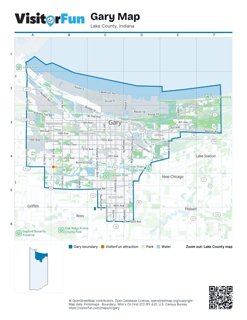
Street index of Gary
Each street on the sheet and the grid squares it crosses.
- Indiana Toll RoadA3, B3, C3, D3, E3, D4, E4
- Borman ExpresswayA4, B4, C4, D4, E4
- Cline AvenueA1, A2, A3, A4
- Casimir Pulaski Memorial HighwayD3, D4, D6
- West 5th AvenueA3, B3, C3
- BroadwayC3, C4, C5, C6
- Richard G. Hatcher BoulevardC3, C4, C5
- East 5th AvenueC3, D3, E3, F3
- West 4th AvenueA3, B3, C3
- West Ridge RoadA5, B5, C5
- Airport RoadA2, B2, B3
- Melton RoadE3, F3
- Buchanan StreetC3, C4, C5, C6
- East Dunes HighwayE3, F3
- Bridge StreetB3, C3
- East 4th AvenueC3, D3, E3, F3
- East Ridge RoadC5, D5
- North Buchanan StreetC3
- Ripley StreetF2, F3
- North Ripley StreetF2, F3
- Ridge RoadD5
- Dunes HighwayF3
- West 15th AvenueA4, B4, C4
- Martin Luther King DriveD3, D4, D5
- Madison StreetC3, C4, C5, C6
- Burr StreetB3, B4, B5
- Tennessee StreetD3, D4, D5, D6
- East 15th AvenueC4, D4, E4
- Central AvenueC3, D3, D4, E4
- Cleveland StreetC3, C4, C5
- Ohio StreetD3, D4, D5
- West 45th AvenueC5
- North Lake StreetE2, E3
- Access RoadA3, D3, A4
- South Lake StreetE3
- Chicago AvenueA2
- Gary RoadA2
- 169th StreetA4
- Guthrie StreetA2
- West 25th AvenueA4, B4, C4
- Clark RoadB2, B3, B4, B5
- Harrison StreetC3, C4, C5, C6
- Georgia StreetD3, D4, D5, D6
- Massachusetts StreetC3, C4, C5, C6
- West 11th AvenueA3, B3, C3
- Chase StreetB3, B4, B5
- West 21st AvenueA4, B4, C4
- West 19th AvenueB4, C4
- West 9th AvenueA3, B3, C3
- West 35th AvenueA5, B5, C5
- Taft StreetC3, C4, B5, C5
- West 7th AvenueA3, B3, C3
- East 7th AvenueC3, D3, E3
- Malcolm X DriveC3, C4
- Colfax StreetA3, A4
- Oak AvenueE2, F2, E3
- West 2nd AvenueA3, B3, C3
- West 8th AvenueB3, C3
- Clay StreetE3, E4
- Miller AvenueE3
- East 21st AvenueC4, D4
- Forest AvenueE3, F3
- West 29th AvenueA4, B4
- Hemlock AvenueE3, F3
- Mississippi StreetD3, D4, D5
- Whitcomb StreetB3, B4, B5
- Buffington Harbor DriveA2
- East 10th AvenueC3, D3, E3
- East 15th PlaceD4, E4
- East 35th AvenueC5, D5
- West 41st AvenueC5, D5
- East 19th AvenueC4, D4
- Harrison BoulevardC3, C4, C5
- East 8th AvenueC3, D3
- Birch AvenueB3, E3
- East 49th AvenueC6, D6
- West 47th AvenueC6
- Industrial HighwayB3
- South County Line RoadF3
- Montgomery StreetE2, E3
- North County Line RoadF2, F3
- West 39th AvenueC5, D5
- Wabash AvenueB3, C3
- Hobart RoadE3
- East 45th AvenueC5, D5
- East 11th AvenueC3, E3
- East 37th AvenueC5, D5
- North Grand BoulevardE3
- Aetna StreetD3, E3, E4
- Marquette DriveE2, E3
- West 49th AvenueC6
- East 47th AvenueC6, D6
- North Shelby StreetF2, F3
- South Grand BoulevardE3
- 177th StreetA4
- Lake StreetE3
- Ellis AvenueC4, D4
- Route 14B2, C2, C3, D3
- Jefferson StreetC3, C4, C5, C6
- Delaware StreetC3, C4, C5, C6
- Connecticut StreetC3, C4, C5, C6
- Washington StreetC3, C4, C5, C6
- Jackson StreetC3, C4, C5, C6
- Adams StreetC3, C4, C5, C6
- Pennsylvania StreetC3, C4, C5, C6
- Pierce StreetC3, C4, C5, C6
- West 23rd AvenueA4, B4, C4
- Route 4B2, C2
- Van Buren StreetC3, C4, C5, C6
- Maryland StreetC3, C4, C5, C6
- Route 1C2, D2, D3
- West 13th AvenueB3, C3
- Lincoln StreetC3, C4, D4, C5, C6
- Carolina StreetC3, C4, C5, D5, C6, D6
- West 24th AvenueA4, B4, C4
- Monroe StreetC3, C4, C5, C6
- Johnson StreetC3, C4, C5, C6
- Polk StreetC3, C4, C5, C6
- Route 18C3, D3, E3
- Fillmore StreetC3, C4, C5, C6
- Kentucky StreetD3, D4, D5, D6
- Tyler StreetC3, C4, C5, C6
- Vermont StreetD3, D4, D5, D6
- West 10th AvenueA3, B3, C3
- West 6th AvenueA3, B3, C3
- West 3rd AvenueA3, B3, C3
- Garfield StreetC3, C4, C5, C6
- West 17th AvenueB4, C4
- Route 20 / Clark RoadB2, C2, C3
- Roosevelt StreetC3, C4, C5
- Calhoun StreetA3, A4, A5
- Rhode Island StreetD3, D4, D5, D6
- Hanley StreetB3, B4
- Taney StreetB3, B4, B5
- West 22nd AvenueA4, B4, C4
- Gerry StreetB3, B4, A5, B5
- West 20th AvenueA4, B4, C4
- Virginia StreetC3, C5, C6
- West 20th PlaceA4, B4, C4
- East 6th AvenueC3, D3, E3, F3
- Louisiana StreetD3, D4, D5, D6
- Ellsworth StreetB3, B4, B5
- East 13th AvenueC3, D3, E3
- West 26th AvenueA4, B4, C4
- Marshall StreetB3, B4, B5
- Mount StreetB3, B4
- West 2nd PlaceB3, C3
- West 37th AvenueA5, B5, C5
- Durbin StreetB3, B4, B5
- West 27th AvenueA4, B4, C4
- Lakefront RoadC2
- Rutledge StreetB3, B4, C5
- West 19th PlaceB4, C4
- Arthur StreetC3, C4, C5, C6
- Morton StreetB3, B4
- East 24th AvenueC4, D4, E4
- Hendricks StreetB3, B4, B5
- Ralston StreetB3, B4
- West 36th AvenueA5, C5
- Jennings StreetB3, B4
- Williams StreetB3, B4, B5
- Route 13C2
- Wright StreetB3, B4
- Hovey StreetB3, B4
- Stevenson StreetA3, A4
- Indian BoundaryE2, F2
- Hayes StreetC3, C4, C5
- Hamlin StreetA3, A4
- Blaine StreetA3, A4
- Hobart StreetA3, A4
- Roosevelt PlaceC3, C4, C5
- Route 12D3
- Juniper AvenueE2, F2, E3, F3
- Noble StreetB3, B4
- Dallas StreetA3, A4
- Waite StreetB3, B4, B5
- King StreetA3, A4
- West 38th AvenueB5, C5, D5
- Taney PlaceB3, B4, B5
- East 20th AvenueC4, D4
- Route 8C2
- Route 5C2, C3
- Route 3C2, C3, D3
- Ash AvenueE3, F3
- West 12th AvenueB3, C3
- West 28th AvenueA4, B4, C4
- Maple AvenueE2, F2
- Mc Kinley StreetC3, C4, C5
- West 30th AvenueA4, B4, C4
- Route 6C2
- Wallace StreetB3, B4
- Lake Shore DriveF2
- Tompkins StreetA3, A4, A5
- Matthews StreetB3
- West 43rd AvenueC5
- East 40th AvenueC5, D5
- Clinton StreetB3, B4
- West 10th PlaceB3, C3
- East 36th AvenueC5, D5
- East 39th AvenueC5, D5
- Fairbanks StreetA3, A4
- East 43rd AvenueC5, D5
- East 41st AvenueC5, D5
- Porter StreetB3, B4
- East Ore Docks RoadD2, D3
- East 3rd AvenueE3, F3
- Lane StreetB3, B4
- Wilson StreetB3, B4
- Bigger StreetB3, B4
- East 25th AvenueC4, D4, E4
- East 23rd AvenueC4, D4
- East 1st AvenueC3, E3, F3
- West 40th AvenueC5
- Demas RoadD3
- Locust AvenueE2, F2
- East 51st AvenueC6, D6
- East 13th PlaceE3
- East 38th AvenueC5, D5
- Morse StreetA4
- East 16th AvenueC4, D4
- Central DriveD4
- East 44th AvenueC5, D5
- East 22nd AvenueC4, D4
- West 9th PlaceB3, C3
- Ellsworth PlaceB3, B4, B5
- Dakota StreetD3, D4
- Marshall PlaceB3, B4, B5
- Route 7C2, C3
- West 21st PlaceB4
- West 18th AvenueB4, C4
- West 44th AvenueC5
- South Union StreetF3
- East 33rd AvenueC5, D5
- Baker StreetB3, B4
- West 16th AvenueC4
- East 17th AvenueC4, D4
- West 46th AvenueC5
- Ash PlaceE3, F3
- East 53rd AvenueC6, D6
- West 23rd PlaceA4, B4
- Waverly DriveB3, C3
- East 10th PlaceC3, D3, D4
- East 14th AvenueC3, D3, E3, D4
- East 42nd AvenueC5, D5
- East 6th PlaceE3, F3
- West 28th PlaceB4
- Route 20C2
- Taft PlaceC3
- Cass StreetE3, E4
- Allen StreetE3, E4
- McKinley StreetC3
- Pottowatami TrailF2, F3
- West 26th PlaceB4, C4
- West 24th PlaceB4
- West 42nd AvenueC5
- East 5th PlaceE3
- East 52nd AvenueC6, D6
- East 34th AvenueC5, D5
- East 50th AvenueC6, D6
- East 48th AvenueC6, D6
- Lakewood AvenueF3
- Rush StreetF2, F3
- Michigan StreetD3, D4
- East 26th AvenueC4, D4
- 10th PlaceC3
- North Miami StreetE3
- West 48th AvenueC6
- East 35th CourtD5
- East 35th PlaceD5
- East 36th PlaceD5
- Wheeler StreetA3, A4
- East 46th AvenueC5, D5
- Arizona StreetE3, D4, E4
- Mason AvenueC3, D3
- Benton StreetE3, E4
- Willard StreetB3, B4
- North Vanderburg StreetF2, F3
- South Hamilton StreetE3
- East 51st PlaceD6
- West 1st AvenueB3
- Route 11C2
- East 11th PlaceE3
- Fayette StreetE3
- Illinois StreetD3, D4, D5
- East 12th AvenueD3, E3
- West 53rd AvenueC6
- West 22nd PlaceB4, C4
- Marshalltown DriveD4
- Colorado StreetD4
- Hickory AvenueE3, F3
- Edison StreetA3, A4
- Black Oak RoadA4
- West 14th AvenueC3
- 17th AvenueA4, B4
- East 48th PlaceC6, D6
- Parke StreetF2, F3
- South Hancock StreetE3
- Newton StreetF2, F3
- Blast Furnace RowC2, C3
- West 29th PlaceA4, B4
Things to do on the Gary map
Places on the map
- Aetna
- Ambridge Mann
- American Fly-Ash
- Bayless Dune Nature Preserve
- Black Oak
- Bongi borrow pit
- Brunswick
- Buchanan Street Basin
- Buffington Harbor Beach
- Calumet Township
- Clark and Pine Nature Preserve
- CN Kirk Yard
- County Market Plaza
- Downtown Gary
- Downtown West
- East Breakwater Area
- East Grand Calumet Lagoon
- East Shoreline
- Emerson
- Gary Parks Trails Trail
- Gary Sanitary Landfill
- Gary/Chicago International Airport
- Georgia Pacific Landfill
- Gleason Park
- Glen Park
- Grand Calumet River Area of Concern
- Industrial Cinders Landfill
- Ivanhoe Dune and Swale Nature Preserve
- Ivanhoe South Nature Preserve
- Lake Etta
- Lake Etta County Park
- Lake Sandy Jo Superfund Site
- Marquette Park
- Midtown
- Miller Beach
- Pine Station Nature Preserve
- Pulaski
- Tolleston
- West Grand Calumet Lagoon
- Westside
Next to Gary
- Griffith
- Hobart
- Lake Station
- New Chicago
- Ross
© OpenStreetMap contributors, Open Database License, openstreetmap.org/copyright · Map data: Protomaps · Boundary: Who's On First (CC-BY 4.0); U.S. Census Bureau