

Kansas map
Reno County map
About 61,417 people live here (Census Bureau, 2024 estimate). The sheet's index lists 300 streets; North Main Street, West Avenue A and Main Street cross the most grid squares. Things to do inside the boundary: Cosmosphere and Strataca.
Open the map (PDF, US Letter)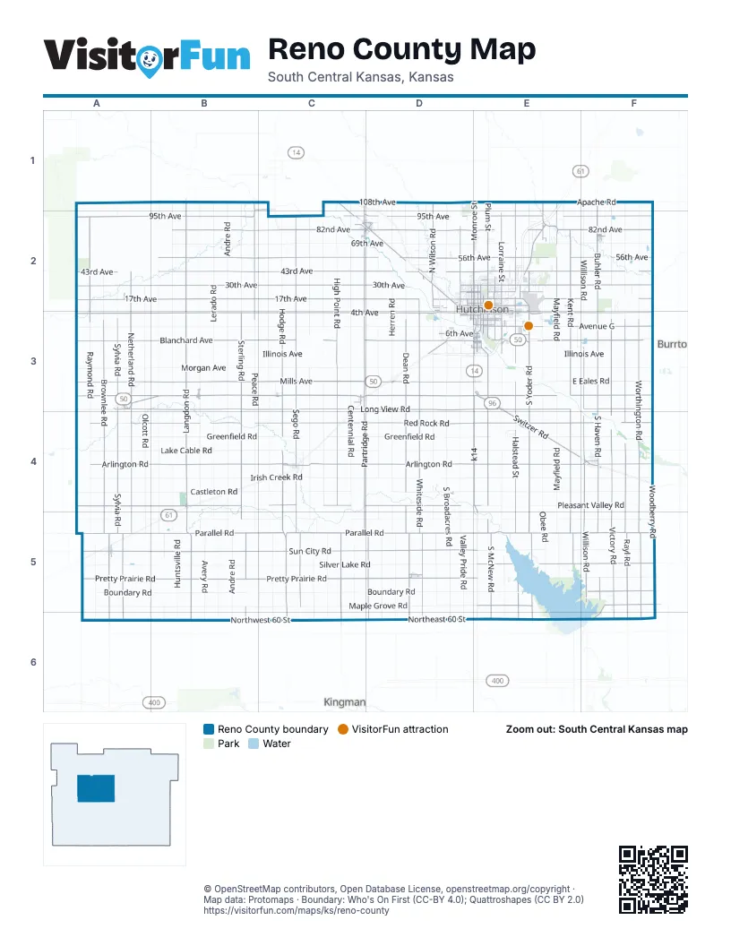
Street index of Reno County
Each street on the sheet and the grid squares it crosses.
- West Illinois AvenueA3, B3, C3, D3, E3
- Ken Kennedy FreewayE1, E2, E3
- East Illinois AvenueE3, F3
- West Mills AvenueA3, B3, C3, D3, E3
- Switzer RoadE3, E4, F4
- United States Highway 50E3, F3
- North Main StreetE2, F2, A3, B3, C3, E3, A5
- South Lorraine StreetE3
- South Main StreetF2, A3, B3, C3, E3
- West Avenue AC2, D2, F2, B3, C3, D3, E3
- East Avenue AD2, B3, E3
- Woodie Seat FreewayE3
- Industrial DriveF4
- West 4th AvenueF2, A3, B3, C3, D3, E3
- South Hodge RoadC3, C4, C5, C6
- East 4th AvenueF2, B3, E3, F3
- East 30th AvenueE2, F2
- k14E3, E4, E5
- Northwest 40 AvenueC6
- West Trail West RoadA3, B3, C3, D3, E3
- West 17th AvenueA2, B2, C2, D2, E2
- West Pretty Prairie RoadA5, B5, C5, D5, E5
- West Sun City RoadA5, B5, C5, D5, E5
- West Long View RoadA3, B3, C3, D3, E3
- West Arlington RoadA4, B4, C4, D4, E4
- West 30th AvenueA2, B2, C2, D2, E2
- West Blanchard AvenueA3, B3, C3, D3, E3
- West Red Rock RoadA4, B4, C4, D4, E4
- West 43rd AvenueA2, B2, C2, D2, E2
- West Parallel RoadA5, B5, C5, D5, E5
- West Pleasant Valley RoadA4, B4, C4, D4, E4
- West 82nd AvenueB2, C2, D2, E2
- South Worthington RoadF3, F4, F5, F6
- West 56th AvenueB2, C2, D2, E2
- South Whiteside RoadD3, D4, D5, D6
- South Sylvia RoadA3, A4, A5, A6
- South Partridge RoadC3, C4, C5, D5, D6
- South Brownlee RoadA3, A4, A5, A6
- South Langdon RoadB3, B4, B5, B6
- South Dean RoadD3, D4, D5, D6
- South Victory RoadF3, F4, F5, F6
- West 95th AvenueA2, B2, C2, D2
- South Rayl RoadF3, F4, F5, F6
- South Sego RoadC3, C4, C5
- South High Point RoadC3, C4, C5, C6
- South Sterling RoadB3, B4, B5, B6
- South McNew RoadE3, E4, E5, E6
- South Halstead StreetE3, E4, E5, E6
- South Willison RoadF3, F4, F5
- South Yoder RoadE3, E4, E5, E6
- South Kent RoadE3, E4, E5
- South Haven RoadF3, F4, F5
- South Netherland RoadA3, A4, A5
- East Parallel RoadE5, F5
- East Trail West RoadE3, F3
- East Long View RoadE3, F3
- East 43rd AvenueE2, F2
- East Arlington RoadE4, F4
- East Silver Lake RoadE5, F5
- East Red Rock RoadE4, F4
- East 95th AvenueE2, F2
- East 56th AvenueE2, F2
- East 82nd AvenueE2, F2
- North Langdon RoadB1, B2, B3
- North Plum StreetE1, E2, E3, B4
- North Peace RoadB1, B2, B3
- North Monroe StreetE1, E2, E3
- North Halstead StreetE1, E2, E3
- North Raymond RoadA2, A3
- North Buhler RoadF1, F2, F3
- North Lorraine StreetE2, E3
- North Mayfield RoadE1, E2, E3
- North Sego RoadC2, C3
- East 17th AvenueE2, F2
- North Wilson RoadD1, D2
- East Avenue GC3, E3, F3
- North Nickerson RoadC1, C2, C3
- East Maple Grove RoadE5, F5
- North Hendricks StreetD2, D3
- North Kent RoadE2, E3
- Parallel RoadC5, D5
- Nickerson BoulevardD2
- Boundary RoadF5
- East 11th AvenueE2
- West Nickerson BoulevardC2, D2
- Old K 61E2
- Avenue GC2, D2, E3, F3
- West 6th AvenueD2, E2, F2, B3, D3, E3
- East 23rd AvenueE2
- North Netherland RoadA2, A3
- North Severance StreetE2, E3
- Medora RoadE1, E2
- East Avenue BD2, A3, B3, C3, E3
- East 3rd AvenueB3, E3
- East 6th AvenueE2, B3, E3
- North Adams StreetE2, D3, E3, D5
- East Blanchard AvenueE3
- North Van Buren StreetD2, D3
- South Plum StreetE3, B4, D5
- North Poplar StreetE2, E3
- West 11th AvenueD2, E2
- Railroad StreetC1, C2, D2
- West 2nd AvenueF2, B3, D3, E3
- East Avenue FA3, C3, D3, E3
- West Main StreetB4, C4, D4, F4, D5
- South Poplar StreetE3
- West 9th AvenueD2, E2
- East 9th AvenueE2
- North Airport RoadE2, E3
- East Main StreetB4, C4, F4, D5
- West 5th AvenueD2, F2, B3, D3, E3
- Blanchard Road SouthwestD3
- South Severance StreetE3
- North Whiteside RoadD2, D3
- Lucille DriveE2
- South Buhler RoadF3
- County Route 556F5, F6
- Arlington RoadC4, E4
- West 24th AvenueD2, E2
- South Airport RoadE3
- Woodbury RoadF3
- Trail West Road SouthwestA3
- West Avenue FD2, A3, C3, D3, E3
- Main StreetE2, A3, C4, D4, E4, A5, D5
- East 13th AvenueE2
- West 13th AvenueD2, E2
- South Adams StreetD3, E3, D5
- Apple LaneE2, D5
- Maple Grove RoadF5
- Hoist StreetB1, C1
- West 23rd AvenueD2, E2
- East 85th AvenueE2
- Buhler RoadF2, F3
- Pleasant Valley RoadB4, E4
- Kansas AvenueE2, E3
- North Morgan StreetC2
- West 3rd AvenueB3, D3, E3
- Scott BoulevardE3
- South Morgan StreetC2
- Howard StreetE3, C4
- Nickerson StreetD2
- North Burns StreetA5
- East Price StreetA5
- South Monroe StreetE3
- 101st StreetC1
- North Partridge RoadC3
- West 37th Street NorthF5
- Woodlawn StreetD2
- 8th AvenueF1, F2
- South Nickerson StreetC2, D2
- Hodge RoadC5
- North Howard StreetC4
- South Front StreetB4, D4
- West Price StreetA5
- State StreetE3
- Old Highway 50A3
- North Berry AvenueC6
- South Lyons StreetC3
- South Burns StreetA5
- South Van Buren StreetD3
- Front StreetB4, D4
- West Dutch AvenueF2
- Northwest 170 AvenueA6
- 9th RoadB1
- Mc New RoadE3
- 22nd RoadC1
- Trail West RoadC3
- John StreetD2
- Langdon RoadB4
- West Morgan AvenueA3, B3, C3, D3, E3
- West Maple Grove RoadA5, B5, C5, D5, E5
- West Boundary RoadA5, B5, C5, D5, E5
- West Silver Lake RoadA5, B5, C5, D5, E5
- West Castleton RoadA4, B4, C4, D4, E4
- West Lake Cable RoadA4, B4, C4, D4, E4
- West Clark RoadA3, B3, C3, D3
- West Fountain Green RoadA5, B5, C5, D5, E5
- West 69th AvenueB2, C2, D2, E2
- South Peace RoadB3, B4, B5, C5, C6
- South Andre RoadB3, B4, B5, B6
- South Olcott RoadA3, A4, A5, A6
- South Broadacres RoadD3, D4, D5, D6
- South Centennial RoadC3, C4, C5, C6
- South Raymond RoadA3, A4, A5, A6
- South Lerado RoadB3, B4, B5, B6
- South Herren RoadD3, D4, D5, D6
- South Avery RoadB3, B4, B5, B6
- South Huntsville RoadB3, B4, B5, B6
- South Valley Pride RoadD3, D4, D5, D6
- West Irish Creek RoadA4, B4, C4, D4, E4
- South Fairview RoadC3, C4, C5, C6
- South Mayfield RoadE3, E4, E5
- South Riverton RoadD3, D4, D5, D6
- South Jordan Springs RoadB3, B4, B5, B6
- South Bone Springs RoadC3, C4, C5, C6
- South Obee RoadE3, E4, E5
- West Greenfield RoadA4, B4, C4
- South Mohawk RoadD3, D4, D5
- South Salem RoadC3, C4, C5, C6
- Northwest 60 StreetA6, B6, C6
- South Woodberry RoadF3, F4, F5
- East Castleton RoadE4, F4
- West 108th AvenueB1, C1, D1, E1
- East Lake Cable RoadE4, F4
- East Irish Creek RoadE4, F4
- Northeast 60 StreetC6, D6, E6
- East Pleasant Valley RoadE4, F4
- Apache RoadE1, F1
- South Sandcreek RoadE3, E4, E5
- Greenfield RoadC4, D4, E4
- East 69th AvenueE2, F2
- East Eales RoadE3, F3
- East Sun City RoadE5, F5
- East Greenfield RoadE4, F4
- East Pretty Prairie RoadE5, F5
- North Andre RoadB1, B2, B3
- North Lerado RoadB1, B2, B3
- North Huntsville RoadB1, B2, B3
- North Avery RoadB1, B2, B3
- North Worthington RoadF1, F2, F3
- East Fountain Green RoadE5, F5
- North Sterling RoadB1, B2, B3
- North Dean RoadD1, D2, D3
- North Hodge RoadC2, C3
- North Bone Springs RoadC2, C3
- Irish Creek RoadC4, D4
- North Centennial RoadC1, C2, C3
- North Victory RoadF1, F2, F3
- North Rayl RoadF1, F2, F3
- North Willison RoadF1, F2, F3
- Woodberry RoadF2, F3, F5
- North Salem RoadC2, C3
- North High Point RoadC1, C2, C3
- North Herren RoadD1, D2, D3
- East Stroud RoadE3, F3
- Pennington RoadD1, D2
- North Fairview RoadC2, C3
- North Jordan Springs RoadB1, B2, B3
- South Sand Creek RoadE5, E6
- North Brownlee RoadA2, A3
- North Sylvia RoadA1, A2, A3
- East Boundary RoadE5, F5
- East 1st AvenueF2, B3, E3, A5
- East Smoots Creek RoadF6
- South Salt Marsh RoadA3, A4, A5
- East 2nd AvenueF2, B3, E3, A5
- North Yaggy RoadD2
- Clark RoadB3, C3
- North Walnut StreetE2, E3
- North Washington StreetE2, E3
- North Elm StreetE2, E3, D5
- North Madison StreetE2, E3
- North Obee RoadE2, E3
- North Olcott RoadA2, A3
- North Tobacco RoadE2
- North Riverton RoadD2
- East 5th AvenueF2, E3
- East Mills AvenueE3
- South Maple StreetF2, E3, C4, D5
- West 50th AvenueD2
- East 8th AvenueE2, E3
- West 1st AvenueF2, B3, D3, E3, A5
- West Avenue DD2, A3, C3, D3, E3
- North Maple StreetE2, F2, E3, D5
- North Salt Marsh RoadA2, A3
- Emerson LoopE3
- South Elm StreetE3, C4, D5
- East Avenue DD2, A3, C3, E3
- East Avenue CD2, A3, C3, E3
- Sallee RoadD1, D2
- Swede RoadE3
- North Sunrise RoadE1, E2
- Stroud RoadE3
- East 7th AvenueE2, E3
- West Avenue BC2, D2, F2, A3, B3, D3, E3
- East Avenue ED2, A3, C3, E3
- Riverton RoadD1, D2
- North Jefferson StreetE2, E3
- East Sherman AvenueE3
- South Walnut StreetE3, D5
- North Jackson StreetE2, B3, D3, E3
- East 14th AvenueE2
- Tobacco RoadE1, E2
- East 10th AvenueE2, E3
- West Avenue CC2, D2, F2, A3, C3, D3, E3
- Willow Brook DriveD2
- East 20th AvenueE2
- West 15th AvenueD2, E2
- Brandy Lakes RoadE3
- East Morgan AvenueE3
- West Avenue ED2, A3, C3, D3, E3
- Summers RoadE2
- West 14th AvenueD2, E2
- East 26th AvenueE2
- 95th AvenueC2
- North Waldron StreetE2, E3
- Arabian DriveF2, F3
- South Washington StreetE3
- West 19th AvenueD2, E2
- East Snokomo RoadD1, E2
Things to do on the Reno County map
Places on the map
- Abbyville
- Arlington
- Buhler
- Carey Park
- Carey Park Golf Course
- Cheney Reservoir
- Cheney State Park East Shore Area
- Cheney State Park M&M Point Campground
- Cheney State Park West Shore Area
- Cheney State Park Wichita Point Campground
- Cheney Wildlife Area Refuge
- Crazy Horse Golf club
- Dillon Nature Center
- Dirks Lake
- Fun Valley Sports Complex
- Haven
- Hedrick's Exotic Animal Farm
- Hutchinson
- Hutchinson Clinic
- Hutchinson High School
- Hutchinson Mall
- Hutchinson Regional Airport
- Kansas State Fairgrounds
- Lakeside
- Langdon
- Mall Road
- Midway Rides & Attractions
- Nickerson
- Partridge
- Plevna
- Prairie Dunes
- Pretty Prairie
- Sand Hills State Park
- South Hutchinson
- Sylvia
- The Highlands
- Turon
- Willowbrook
Next to Reno County
- Burrton
- Kingman
© OpenStreetMap contributors, Open Database License, openstreetmap.org/copyright · Map data: Protomaps · Boundary: Who's On First (CC-BY 4.0); Quattroshapes (CC BY 2.0)